1940s Maps of Mills County, Texas
Explore 2 historic maps of Mills County from the 1940s. These maps offer a rare glimpse into what life looked like during the 1940s — showing old roads, neighborhoods, homes, and landmarks that have changed or disappeared over time.
Whether you're researching your family's past, planning a metal detecting trip, or studying how Mills County's landscape evolved across the 1940s, these high-resolution maps are a powerful tool for exploring the history of this region.
- Focus on a specific era: All maps on this page are from the 1940s, giving you a focused view of this time period.
- See what’s changed: Compare century-old streets, trails, and buildings to today's modern landscape using overlays and satellite layers.
- Research with precision: Use these maps for genealogy, historical research, land use analysis, or educational projects.
- View, download, or print: Maps are fully viewable online in high resolution, and can be downloaded or printed for your own records.
Start exploring Mills County's history through authentic maps from the 1940s. This is your window into the past.
Mills County, TX maps
(2)- 1948 Map of Richland Springs, 1966 Print
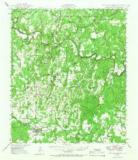 1948 Richland Springs1966 Print · USGSThe northern San Saba County landscape in the late 1940s is defined by its deep river valleys and the presence of the Camp Bowie Military Reservation. Genealogists and historians can trace rural school districts and small settlements like Locker, Skeeterville, and Varga Chapel Church.
 - 1948 Map of Goldthwaite, 1970 Print
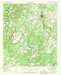 1948 Goldthwaite1970 Print · USGSMills and San Saba Counties come to life in the late 1940s as the railroad and the Colorado River define the local economy. Researchers can trace ancestral footprints at McMillan Cem, Rock Spring School, or the remote Big Valley Church.
End of results
Showing maps 1-2 of 2
Top cities of Mills County
Frequently asked questions
- What are the different types of historical maps available for Mills County?
- What is the oldest map of Mills County?
- Where can I purchase historical maps of Mills County for my home or office?
- Where can I download high-res historical maps of Mills County?
- Are there historical topographic maps available for Mills County?
- Is there historical aerial imagery available for Mills County?
- Where are historical maps of Mills County sourced from?