1970s Maps of Mills County, Texas
Explore 6 historic maps of Mills County from the 1970s. These maps offer a rare glimpse into what life looked like during the 1970s — showing old roads, neighborhoods, homes, and landmarks that have changed or disappeared over time.
Whether you're researching your family's past, planning a metal detecting trip, or studying how Mills County's landscape evolved across the 1970s, these high-resolution maps are a powerful tool for exploring the history of this region.
- Focus on a specific era: All maps on this page are from the 1970s, giving you a focused view of this time period.
- See what’s changed: Compare century-old streets, trails, and buildings to today's modern landscape using overlays and satellite layers.
- Research with precision: Use these maps for genealogy, historical research, land use analysis, or educational projects.
- View, download, or print: Maps are fully viewable online in high resolution, and can be downloaded or printed for your own records.
Start exploring Mills County's history through authentic maps from the 1970s. This is your window into the past.
Mills County, TX maps
(6)- 1979 Map of Priddy
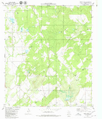
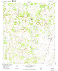 1979 Priddy1979 Print · USGSThe Texas hill country on the Comanche and Mills County line is shown here in the late seventies. Family historians can trace local sites like Priddy Cemetery and Zion Cemetery, or locate landmarks such as Taterhill Mountain and Cedar Gap.
 - 1979 Map of Blanket Springs, 1980 Print
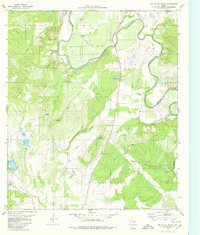
 1979 Blanket Springs1980 Print · USGSThe borderlands of Mills and Brown counties come into focus in the late 1970s, where the winding Pecan Bayou meets a network of ranch roads. Researchers can trace historic routes like the Old Wire Road or locate crossings such as Fisk Crossing Ford and Duke Crossing Ford.
 - 1979 Map of Lake Merritt, 1980 Print
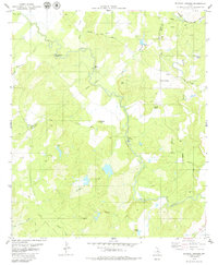
 1979 Lake Merritt1980 Print · USGSMills County ranching and water resources are well-documented in the late seventies as the central Texas landscape transitioned. Genealogists can locate Trigger Mountain Cem and North Browns Cem or trace the Atchison Topeka and Santa Fe rail line.
 - 1979 Map of Zephyr, 1980 Print
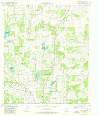
 1979 Zephyr1980 Print · USGSThe community of Zephyr is shown in the late 1970s as a quiet rail-stop along the Atchison Topeka and Santa Fe. Genealogists and local historians can trace family roots at Jenkins Cem or locate the old Rodeo Ground and Water Tank.
 - 1979 Map of Indian Creek, 1980 Print
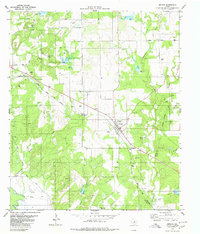
 1979 Indian Creek1980 Print · USGSCentral Texas ranch lands and military grounds meet in the late seventies near the Brown and Mills County line. Genealogists and historians can trace local roots at Indian Creek Cem or Elkins Cem while exploring the banks of Devils River.2 unique versions available
 - 1979 Map of Big Valley South, 1980 Print
 1979 Big Valley South1980 Print · USGSThe Colorado River valley at the San Saba and Mills county line shows a landscape of ranching and river bends in the late seventies. Researchers can trace family origins at the Lower Valley Cem or navigate the terrain around Wildhorse Mountain and Blue Bluff.
End of results
Showing maps 1-6 of 6
Top cities of Mills County
Frequently asked questions
- What are the different types of historical maps available for Mills County?
- What is the oldest map of Mills County?
- Where can I purchase historical maps of Mills County for my home or office?
- Where can I download high-res historical maps of Mills County?
- Are there historical topographic maps available for Mills County?
- Is there historical aerial imagery available for Mills County?
- Where are historical maps of Mills County sourced from?