Old Maps of Mills County, Texas for Genealogy
Trace your family roots with 159 historic maps of Mills County. These high-res maps reveal old neighborhoods, homesites, landmarks, and streets — helping you uncover where your ancestors lived and how the area evolved over time.
- Explore historic neighborhoods: Identify where your relatives may have lived in the 1800s or 1900s.
- Compare maps over time: Trace the changes in streets, buildings, and landmarks for multi-generational research.
- Perfect for genealogy & ancestry research: Used by family historians and researchers to map out lineage and migration.
These maps are an incredible resource for exploring your personal connection to Mills County's past.
Mills County, TX maps
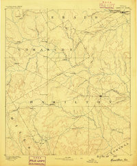
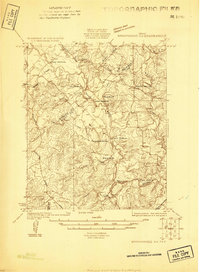
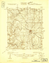
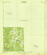
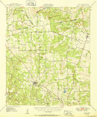
(159)- 1885 Map of San Saba
 1885 San Saba1885 Print · USGSCentral Texas in the late nineteenth century comes alive through this survey of the river valleys and high knobs. Genealogists and researchers can trace the early foundations of San Saba and Goldthwaite, or find forgotten locations like Regency and Bendy.
 - 1887 Map of Lampasas
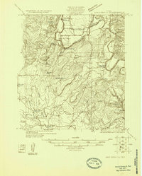
 1887 Lampasas1887 Print · USGSThe Lampasas region in the late 1880s shows the arrival of the Gulf Colorado and Santa Fe Railroad alongside early frontier settlements. Local historians can trace old post offices and milling sites like Townsen Mills, Wayback, and Senterfitt among the numerous gaps and peaks of the Hill Country.
 - 1888 Map of Hamilton
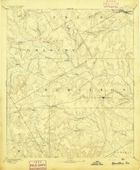
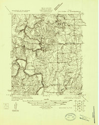
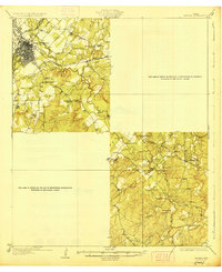
 1888 Hamilton1888 Print · USGSCentral Texas during the 1880s is captured here at a moment of early frontier growth and agricultural settlement. Researchers can trace the original locations of rural centers like Gentry Mill, Pottsville, and the remote post office at Indian Gap.
 - 1889 Map of Brownwood
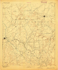
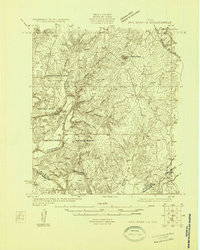
 1889 Brownwood1889 Print · USGSCentral Texas ranching and rail expansion are captured here in the late nineteenth century. You can trace early family settlements and landmarks like Williams Ranch, Comanche, and the path of the Gulf Colorado and Santa Fe Railroad.
 - 1894 Map of Hamilton
 1894 Hamilton1894 Print · USGSCentral Texas ranching and farming communities are captured here in the 1890s, just after the initial frontier period. Genealogists can locate family-named landmarks and early settlements like Gentry Mill, Indian Gap, and Hazle Dell along the Leon River.5 unique versions available
 - 1894 Map of Lampasas
 1894 Lampasas1894 Print · USGSLampasas and the surrounding hill country are shown in the years following the arrival of the rail. Genealogists can trace family-named landmarks like Kinchelo Peak and old post offices at Senterfitt, Nix, and Wayback.4 unique versions available
 - 1894 Map of Brownwood
 1894 Brownwood1894 Print · USGSCentral Texas was undergoing a rapid transformation in the late nineteenth century as rail lines began to reshape the cattle country. Researchers can trace the early footprints of Brownwood, locate the historic Williams Ranch, and follow the progress of the Gulf Colorado and Santa Fe Railroad.6 unique versions available
 - 1894 Map of San Saba
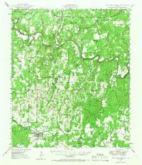
 1894 San Saba1894 Print · USGSCentral Texas in the late nineteenth century is defined here by the meeting of the San Saba River and the Colorado River. Researchers can trace the path of the Gulf Colorado and Santa Fe Railroad near Goldthwaite or locate early settlements like Richland Springs and Red Bluff.4 unique versions available
 - 1925 Map of San Saba 4-a
 1925 San Saba 4-a1925 Print · USGSTexas river life in the mid-twenties is defined by the winding paths of the Colorado and San Saba rivers as they meet near San Saba County. Genealogists can trace early rural communities through Bend Cem and a network of country schools including Colony School and Harmony Ridge School.
 - 1925 Map of San Saba 2-a
 1925 San Saba 2-a1925 Print · USGSMills and San Saba counties are shown in the mid-1920s as rural ranching communities centered on the Colorado River. Genealogists and historians can trace family roots through the Hanna Valley Cem, Ratler, and the Mesquite Church.
 - 1925 Map of Brownwood 3-d
 1925 Brownwood 3-d1925 Print · USGSCentral Texas ranching country along the border of Mills and Brown counties is shown here in the mid-1920s. Researchers can trace historic river fords and family landmarks like Adams Crossing, Slightdale School, and Shaws Ranch.
 - 1925 Map of San Saba 1-c
 1925 San Saba 1-c1925 Print · USGSThe Colorado River valley at the border of Mills and San Saba Counties comes alive in this 1920s survey. Genealogists and local historians can trace the rural school districts of Big Valley School and Liveoak School or locate old river fords like Ogilby Crossing.
 - 1925 Map of San Saba 1-b
 1925 San Saba 1-b1925 Print · USGSMills and San Saba counties are shown during the mid-1920s as the Colorado River winds through a landscape of rural schools and crossings. Researchers can trace early community hubs like Big Valley Church, Ebony School, and the remote Goughenor Crossing.
 - 1925 Map of San Saba 2-b
 1925 San Saba 2-b1925 Print · USGSCentral Texas river life in the mid-twenties is centered here on the winding COLORADO RIVER. You can trace rural family roots at Bowser Cemetery and locate vanished schools like Indian Cr School and Oakland School.
 - 1925 Map of San Saba 1-d
 1925 San Saba 1-d1925 Print · USGSThe Colorado River corridor between Mills and San Saba counties is captured here in the mid-1920s. Genealogists can locate rural community hubs like Nabors Creek School and Shaw Bend School or trace the early Santa Fe rail line.
 - 1925 Map of Brownwood 4-c
 1925 Brownwood 4-c1925 Print · USGSMills County in the mid-1920s shows a landscape transitioning between pioneer ranching roots and modern rail transit. Genealogists can trace family footprints near Williams Ranch, local schoolhouses like Center Point School, or the busy tracks of the Gulf Colorado and Santa Fe in Mullin.
 - 1928 Map of Zephyr
 1928 Zephyr1928 Print · USGSCentral Texas ranching and rail activity are on full display in the mid-1920s as Brownwood expands toward the southeast. Trace ancestral connections at Steppes Creek Church or locate vanished local landmarks like Slighdale School and Adams Crossing.
 - 1928 Map of Goldthwaite
 1928 Goldthwaite1928 Print · USGSThe Colorado River snakes through the Mills and San Saba county line during the mid-twenties, a time of small schoolhouses and river fords. Genealogists can trace family landmarks like San Saba Peak, Big Valley Church, and the Rock Spring School.
 - 1930 Map of Richland Springs
 1930 Richland Springs1930 Print · USGSThe Colorado River divides Mills and San Saba counties in the late 1920s, a period defined by small-town farming and ranching. You can trace early family sites through several river crossings and community hubs like Hanna Valley Cem and the Jones Valley Sch.
 - 1931 Map of Mullin
 1931 Mullin1931 Print · USGSMills County, Texas, was a landscape of rail-driven trade and rural ranching in the mid-1920s. Genealogists and historians can trace family locations near the Gulf Colorado and Santa Fe railroad, Duren Sch, and the old Williams Ranch.
 - 1931 Map of Bend
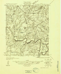
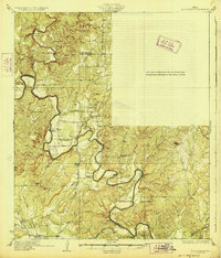
 1931 Bend1931 Print · USGSThe confluence of the Colorado and San Saba rivers in the mid-1920s reveals a rural Texas landscape of river crossings and country schools. Genealogists can trace early homesteads near Bend, the Bend Cem, and several local schoolhouses like Colony Sch.2 unique versions available
 - 1948 Map of Richland Springs, 1966 Print
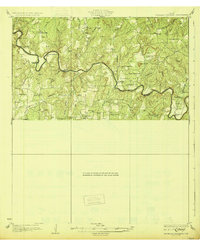
 1948 Richland Springs1966 Print · USGSThe northern San Saba County landscape in the late 1940s is defined by its deep river valleys and the presence of the Camp Bowie Military Reservation. Genealogists and historians can trace rural school districts and small settlements like Locker, Skeeterville, and Varga Chapel Church.
 - 1948 Map of Goldthwaite, 1970 Print
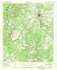 1948 Goldthwaite1970 Print · USGSMills and San Saba Counties come to life in the late 1940s as the railroad and the Colorado River define the local economy. Researchers can trace ancestral footprints at McMillan Cem, Rock Spring School, or the remote Big Valley Church.
 - 1950 Map of Zephyr
 1950 Zephyr1950 Print · USGSBrownwood and the surrounding central Texas countryside are shown at a pivotal mid-century moment as the military and rail industries shaped the local economy. Researchers can locate the sprawling Camp Bowie Military Reservation, find local burial sites like Indian Creek Cemetery, and trace the path of the Santa Fe railroad.2 unique versions available
 - 1950 Map of Mullin
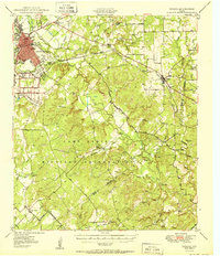
 1950 Mullin1950 Print · USGSThe crossroads of Mills and Brown counties come into focus at the mid-century, centered on the rail hub of Mullin. Researchers can trace old family sites and rural institutions like Williams Ranch, Rock Springs Cem, and the Villa Siding railroad stop.2 unique versions available
Showing maps 1-25 of 159
Top cities of Mills County
Frequently asked questions
- What are the different types of historical maps available for Mills County?
- What is the oldest map of Mills County?
- Where can I purchase historical maps of Mills County for my home or office?
- Where can I download high-res historical maps of Mills County?
- Are there historical topographic maps available for Mills County?
- Is there historical aerial imagery available for Mills County?
- Where are historical maps of Mills County sourced from?