1800s (19th Century) Maps of Mills County, Texas
Explore 8 historic maps of Mills County from the 1800s (19th Century). These maps offer a rare glimpse into what life looked like during the 1800s — showing old roads, neighborhoods, homes, and landmarks that have changed or disappeared over time.
Whether you're researching your family's past, planning a metal detecting trip, or studying how Mills County's landscape evolved across the 1800s, these high-resolution maps are a powerful tool for exploring the history of this region.
- Focus on a specific era: All maps on this page are from the 1800s, giving you a focused view of this time period.
- See what’s changed: Compare century-old streets, trails, and buildings to today's modern landscape using overlays and satellite layers.
- Research with precision: Use these maps for genealogy, historical research, land use analysis, or educational projects.
- View, download, or print: Maps are fully viewable online in high resolution, and can be downloaded or printed for your own records.
Start exploring Mills County's history through authentic maps from the 1800s. This is your window into the past.
Mills County, TX maps
(8)- 1885 Map of San Saba
 1885 San Saba1885 Print · USGSCentral Texas in the late nineteenth century comes alive through this survey of the river valleys and high knobs. Genealogists and researchers can trace the early foundations of San Saba and Goldthwaite, or find forgotten locations like Regency and Bendy.
 - 1887 Map of Lampasas
 1887 Lampasas1887 Print · USGSThe Lampasas region in the late 1880s shows the arrival of the Gulf Colorado and Santa Fe Railroad alongside early frontier settlements. Local historians can trace old post offices and milling sites like Townsen Mills, Wayback, and Senterfitt among the numerous gaps and peaks of the Hill Country.
 - 1888 Map of Hamilton
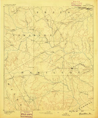 1888 Hamilton1888 Print · USGSCentral Texas during the 1880s is captured here at a moment of early frontier growth and agricultural settlement. Researchers can trace the original locations of rural centers like Gentry Mill, Pottsville, and the remote post office at Indian Gap.
 - 1889 Map of Brownwood
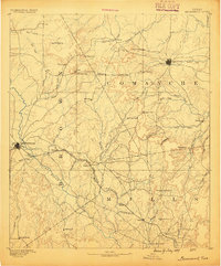
 1889 Brownwood1889 Print · USGSCentral Texas ranching and rail expansion are captured here in the late nineteenth century. You can trace early family settlements and landmarks like Williams Ranch, Comanche, and the path of the Gulf Colorado and Santa Fe Railroad.
 - 1894 Map of Hamilton
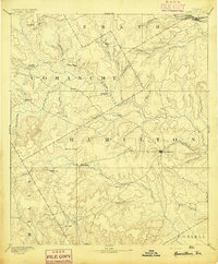 1894 Hamilton1894 Print · USGSCentral Texas ranching and farming communities are captured here in the 1890s, just after the initial frontier period. Genealogists can locate family-named landmarks and early settlements like Gentry Mill, Indian Gap, and Hazle Dell along the Leon River.5 unique versions available
 - 1894 Map of Lampasas
 1894 Lampasas1894 Print · USGSLampasas and the surrounding hill country are shown in the years following the arrival of the rail. Genealogists can trace family-named landmarks like Kinchelo Peak and old post offices at Senterfitt, Nix, and Wayback.4 unique versions available
 - 1894 Map of Brownwood
 1894 Brownwood1894 Print · USGSCentral Texas was undergoing a rapid transformation in the late nineteenth century as rail lines began to reshape the cattle country. Researchers can trace the early footprints of Brownwood, locate the historic Williams Ranch, and follow the progress of the Gulf Colorado and Santa Fe Railroad.6 unique versions available
 - 1894 Map of San Saba
 1894 San Saba1894 Print · USGSCentral Texas in the late nineteenth century is defined here by the meeting of the San Saba River and the Colorado River. Researchers can trace the path of the Gulf Colorado and Santa Fe Railroad near Goldthwaite or locate early settlements like Richland Springs and Red Bluff.4 unique versions available
End of results
Showing maps 1-8 of 8
Top cities of Mills County
Frequently asked questions
- What are the different types of historical maps available for Mills County?
- What is the oldest map of Mills County?
- Where can I purchase historical maps of Mills County for my home or office?
- Where can I download high-res historical maps of Mills County?
- Are there historical topographic maps available for Mills County?
- Is there historical aerial imagery available for Mills County?
- Where are historical maps of Mills County sourced from?