1970s Maps of Oldham County, Texas
Explore 12 historic maps of Oldham County from the 1970s. These maps offer a rare glimpse into what life looked like during the 1970s — showing old roads, neighborhoods, homes, and landmarks that have changed or disappeared over time.
Whether you're researching your family's past, planning a metal detecting trip, or studying how Oldham County's landscape evolved across the 1970s, these high-resolution maps are a powerful tool for exploring the history of this region.
- Focus on a specific era: All maps on this page are from the 1970s, giving you a focused view of this time period.
- See what’s changed: Compare century-old streets, trails, and buildings to today's modern landscape using overlays and satellite layers.
- Research with precision: Use these maps for genealogy, historical research, land use analysis, or educational projects.
- View, download, or print: Maps are fully viewable online in high resolution, and can be downloaded or printed for your own records.
Start exploring Oldham County's history through authentic maps from the 1970s. This is your window into the past.
Oldham County, TX maps
(12)- 1971 Map of Romero SE, 1973 Print
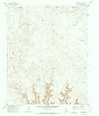
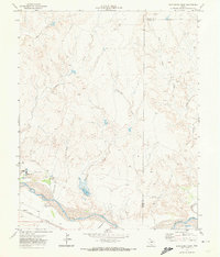
 1971 Romero SE1973 Print · USGSThe Texas Panhandle breaks along the Canadian River are documented here in the early seventies, showing a ranching landscape centered on remote water sources. Researchers can trace the ranching infrastructure of the era through sites like Old Santa Fe Windmill, East Chavez Windmill, and Horseshoe Tank.
 - 1971 Map of Bivins Channing Ranch, 1973 Print
 1971 Bivins Channing Ranch1973 Print · USGSTexas Panhandle ranching and energy production intersect in the early seventies at the junction of Hartley, Moore, and Oldham Counties. Researchers can trace land use at the Bivins Channing Ranch, the settlement of Heldon, and numerous Gas Wells.2 unique versions available
 - 1971 Map of Proctor Ranch, 1973 Print
 1971 Proctor Ranch1973 Print · USGSThe Texas Panhandle ranching landscape comes into focus in the early seventies, centered on the Proctor Ranch. Genealogists and researchers can trace local landmarks like Punta de Agua Creek and family-named sites such as Cruz Windmill.
 - 1971 Map of Nara Visa, 1973 Print
 1971 Nara Visa1973 Print · USGSThe ranching landscape of Quay County is documented here in the early 1970s, as the railroad still shaped the high plains. Genealogists and historians can trace family-named water sources like Jones Well and McAlister Well near Nara Visa.
 - 1971 Map of Knoblaw, 1973 Print
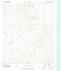
 1971 Knoblaw1973 Print · USGSThe high plains of the Texas Panhandle were a landscape of managed water and vast ranches in the early 1970s. Researchers can trace land use through a network of named sites like Thousand Dollar Dam, Chisum Spring, and the Trujillo Well.2 unique versions available
 - 1971 Map of Channing NW, 1973 Print
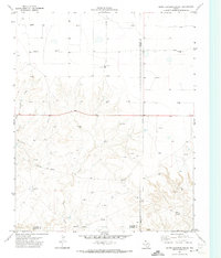
 1971 Channing NW1973 Print · USGSHartley County at the start of the 1970s reveals a ranching landscape structured by its water sources and county lines. Genealogists and historians can trace old landmarks like Flats Windmill and the drainage of Rita Blanca Creek across the high plains.
 - 1971 Map of Many Post Camp, 1974 Print
 1971 Many Post Camp1974 Print · USGSThe Texas Panhandle in the early seventies remained a landscape of isolated ranching outposts and river crossings. Researchers can trace the water-dependent economy of the region through landmarks like Many Post Camp, the Old Farm Crossing, and Oil Well Spring.
 - 1971 Map of Boys Ranch West, 1974 Print
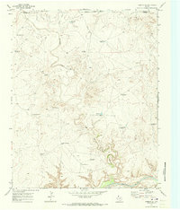
 1971 Boys Ranch West1974 Print · USGSThe Canadian River breaks in Oldham County appear here in the early 1970s, showcasing a landscape shaped by ranching and the railroad. Genealogists and historians can locate Tascosa, Boot Hill Cem, and the specialized facilities at Boys Ranch.
 - 1971 Map of Boys Ranch East, 1974 Print
 1971 Boys Ranch East1974 Print · USGSThe Texas Panhandle comes into focus during the early 1970s as the Canadian River valley transitions between ranching and energy development. Researchers can trace the layout of Boys Ranch, locate the Tascosa Cem, and follow the Ft Worth and Denver rail line.
 - 1971 Map of Torrey House, 1974 Print
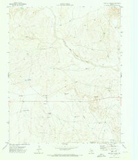
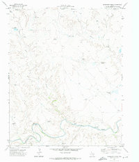
 1971 Torrey House1974 Print · USGSOldham County ranching country is captured here in the early seventies as a network of camps and canyons along the Canadian River. Researchers can trace the layout of the historic Torrey House (Ruins) and locate remote outposts like Bird Farm Camp and Isabelle Camp.
 - 1971 Map of Channing, 1974 Print
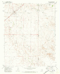
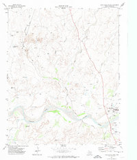
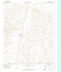 1971 Channing1974 Print · USGSThe Texas Panhandle town of Channing is captured in the early seventies as a rail-centered community on the edge of a growing energy landscape. Researchers can trace the Fort Worth and Denver line, find the local Cem, and see the Rodeo Ground.
 - 1971 Map of Humdinger Spring, 1974 Print
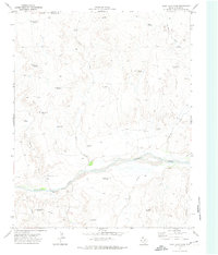
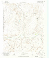
 1971 Humdinger Spring1974 Print · USGSThe Texas Panhandle cattle country of the early seventies is mapped here along the winding Canadian River and the Hartley-Oldham county line. Researchers can trace old livestock routes and water sources, from Humdinger Spring to river fords like Partwood Crossing.
End of results
Showing maps 1-12 of 12
Top cities of Oldham County
Frequently asked questions
- What are the different types of historical maps available for Oldham County?
- What is the oldest map of Oldham County?
- Where can I purchase historical maps of Oldham County for my home or office?
- Where can I download high-res historical maps of Oldham County?
- Are there historical topographic maps available for Oldham County?
- Is there historical aerial imagery available for Oldham County?
- Where are historical maps of Oldham County sourced from?