1890s Maps of Palo Pinto County, Texas
Explore 2 historic maps of Palo Pinto County from the 1890s. These maps offer a rare glimpse into what life looked like during the 1890s — showing old roads, neighborhoods, homes, and landmarks that have changed or disappeared over time.
Whether you're researching your family's past, planning a metal detecting trip, or studying how Palo Pinto County's landscape evolved across the 1890s, these high-resolution maps are a powerful tool for exploring the history of this region.
- Focus on a specific era: All maps on this page are from the 1890s, giving you a focused view of this time period.
- See what’s changed: Compare century-old streets, trails, and buildings to today's modern landscape using overlays and satellite layers.
- Research with precision: Use these maps for genealogy, historical research, land use analysis, or educational projects.
- View, download, or print: Maps are fully viewable online in high resolution, and can be downloaded or printed for your own records.
Start exploring Palo Pinto County's history through authentic maps from the 1890s. This is your window into the past.
Palo Pinto County, TX maps
(2)- 1890 Map of Breckenridge
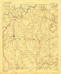 1890 Breckenridge1890 Print · USGSStephens County was a landscape of budding settlements and cattle country in the late nineteenth century. Genealogists can trace early homesteads near Breckenridge or follow the Texas and Pacific R.R. past peaks like Steal Easy Mt. and Gunsight Mt..6 unique versions available
 - 1891 Map of Palo Pinto
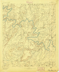 1891 Palo Pinto1891 Print · USGSNorth Texas in the late nineteenth century was a landscape of winding river bends and emerging coal towns. Genealogists and historians can trace early river crossings at Oaks Ferry, the path of the Texas and Pacific Railroad, and the Coal Mines at Coalville.7 unique versions available
End of results
Showing maps 1-2 of 2
Top cities of Palo Pinto County
- Strawn historical maps
- Graford historical maps
- Gordon historical maps
- Palo Pinto historical maps
- Mingus historical maps
Frequently asked questions
- What are the different types of historical maps available for Palo Pinto County?
- What is the oldest map of Palo Pinto County?
- Where can I purchase historical maps of Palo Pinto County for my home or office?
- Where can I download high-res historical maps of Palo Pinto County?
- Are there historical topographic maps available for Palo Pinto County?
- Is there historical aerial imagery available for Palo Pinto County?
- Where are historical maps of Palo Pinto County sourced from?