1920s Maps of Palo Pinto County, Texas
Explore 9 historic maps of Palo Pinto County from the 1920s. These maps offer a rare glimpse into what life looked like during the 1920s — showing old roads, neighborhoods, homes, and landmarks that have changed or disappeared over time.
Whether you're researching your family's past, planning a metal detecting trip, or studying how Palo Pinto County's landscape evolved across the 1920s, these high-resolution maps are a powerful tool for exploring the history of this region.
- Focus on a specific era: All maps on this page are from the 1920s, giving you a focused view of this time period.
- See what’s changed: Compare century-old streets, trails, and buildings to today's modern landscape using overlays and satellite layers.
- Research with precision: Use these maps for genealogy, historical research, land use analysis, or educational projects.
- View, download, or print: Maps are fully viewable online in high resolution, and can be downloaded or printed for your own records.
Start exploring Palo Pinto County's history through authentic maps from the 1920s. This is your window into the past.
Palo Pinto County, TX maps
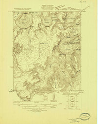
(9)- 1924 Map of Breckenridge 1-a
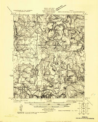 1924 Breckenridge 1-a1924 Print · USGSNorth Central Texas oil and ranching lands are captured here in the mid-1920s at the junction of three counties. Genealogists can locate family homesteads near Eliasville PO, Sorghum Flat School, or the petroleum derricks at Eubanks Derrick.
 - 1924 Map of Palo Pinto 2-b
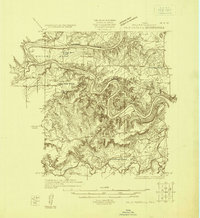
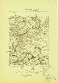 1924 Palo Pinto 2-b1924 Print · USGSThe Brazos River winds through Palo Pinto and Young counties in the mid-twenties, long before the creation of modern reservoirs. Researchers can locate the Pickwick settlement, several river transits like Wild Bend Crossing, and the McAdams Cem.
 - 1924 Map of Palo Pinto 2-a
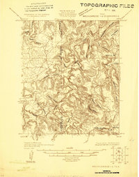
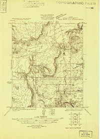 1924 Palo Pinto 2-a1924 Print · USGSPalo Pinto County at the mid-point of the twenties is captured here in an advance survey of its settlements and rugged bluffs. Genealogists and researchers can locate Grassy Ridge School or trace the early W. M. W. & N. W. rail line through Graford and Dalton.
 - 1924 Map of Palo Pinto 1-b
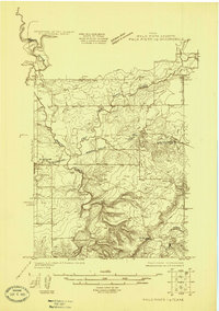 1924 Palo Pinto 1-b1924 Print · USGSPalo Pinto County in the mid-1920s is captured here as a landscape of rural schools and emerging rail connections. Researchers can trace the path of the Weatherford and Mineral Wells Northwestern and find local hubs like Graford and the Union Hill School.
 - 1924 Map of Palo Pinto 2-c
 1924 Palo Pinto 2-c1924 Print · USGSThe Brazos River meanders through Palo Pinto County in the mid-1920s, showing the landscape before the creation of the reservoir. Genealogists and researchers can trace family-named river fords and landmarks like Belding Ranch, Fortune Bend School, and Johnson Crossing.
 - 1924 Map of Breckenridge 1-d
 1924 Breckenridge 1-d1924 Print · USGSThe borderlands of Stephens and Palo Pinto counties are captured here in the mid-1920s, showing a rugged landscape of winding creek beds and family-named hollows. Genealogists and researchers can locate old landmarks like Cedar Springs Church, Hayrick Mt, and Hog Bend.
 - 1925 Map of Palo Pinto 4-b
 1925 Palo Pinto 4-b1925 Print · USGSPalo Pinto County in the mid-twenties shows a landscape of sharp river bends and scattered rural schoolhouses. Genealogists and local historians can locate early educational landmarks like Progress School and New Hope School or trace the Texas and Pacific rail line.
 - 1927 Map of Pickwick
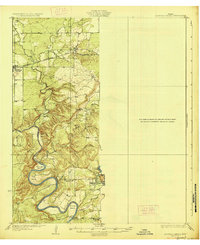
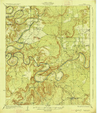 1927 Pickwick1927 Print · USGSThe Brazos River loops through Palo Pinto and Young Counties in the mid-1920s, showing the river's path before the dams. Genealogists can trace family landmarks like Mc Adams Cem, Henry Chapel, and the isolated Belding Ranch.2 unique versions available
 - 1927 Map of Mineral Wells
 1927 Mineral Wells1927 Print · USGSThe Brazos River carves a winding path through Palo Pinto County in the mid-1920s, defining a landscape of deep hollows and sharp river bends. Researchers can trace early rural schools like Union Hill School and the route of the Weatherford Mineral Wells and Northwestern rail line.2 unique versions available
End of results
Showing maps 1-9 of 9
Top cities of Palo Pinto County
- Strawn historical maps
- Graford historical maps
- Gordon historical maps
- Palo Pinto historical maps
- Mingus historical maps
Frequently asked questions
- What are the different types of historical maps available for Palo Pinto County?
- What is the oldest map of Palo Pinto County?
- Where can I purchase historical maps of Palo Pinto County for my home or office?
- Where can I download high-res historical maps of Palo Pinto County?
- Are there historical topographic maps available for Palo Pinto County?
- Is there historical aerial imagery available for Palo Pinto County?
- Where are historical maps of Palo Pinto County sourced from?