1920s Maps of Runnels County, Texas
Explore 9 historic maps of Runnels County from the 1920s. These maps offer a rare glimpse into what life looked like during the 1920s — showing old roads, neighborhoods, homes, and landmarks that have changed or disappeared over time.
Whether you're researching your family's past, planning a metal detecting trip, or studying how Runnels County's landscape evolved across the 1920s, these high-resolution maps are a powerful tool for exploring the history of this region.
- Focus on a specific era: All maps on this page are from the 1920s, giving you a focused view of this time period.
- See what’s changed: Compare century-old streets, trails, and buildings to today's modern landscape using overlays and satellite layers.
- Research with precision: Use these maps for genealogy, historical research, land use analysis, or educational projects.
- View, download, or print: Maps are fully viewable online in high resolution, and can be downloaded or printed for your own records.
Start exploring Runnels County's history through authentic maps from the 1920s. This is your window into the past.
Runnels County, TX maps
(9)- 1921 Map of Baker Flat
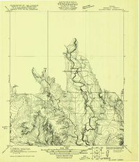
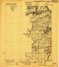 1921 Baker Flat1921 Print · USGSRunnels County ranch lands and rural school districts are captured in this early 1920s survey. Researchers can locate the Red Bank School and trace the drainage of Antelope Creek through the Baker Flat area.
 - 1921 Map of Hatchel
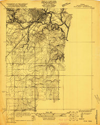
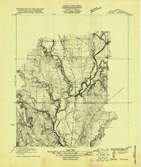 1921 Hatchel1921 Print · USGSRunnels County enters the early twenties as a landscape of creek-side schools and steam-era rail lines. Family historians can locate Eagle School, Runnels School, and the Runnels Cemetery along the Abilene and Southern route.
 - 1921 Map of Lowake
 1921 Lowake1921 Print · USGSLowake and the Concho County ranchlands are captured here in the early 1920s as the railroad drove local commerce. Genealogists and historians can trace the locations of rural schoolhouses like Sweet Home School and Green Wall School near the banks of Little Concho Creek.
 - 1921 Map of Maverick
 1921 Maverick1921 Print · USGSThe rural landscape of Runnels and Coke County is captured here in the early 1920s, showing the early infrastructure of the Maverick area. Researchers can locate the Brookshire School and trace the original courses of Oak Creek and the Colorado River.
 - 1921 Map of Quarry Creek
 1921 Quarry Creek1921 Print · USGSRunnels County ranchlands are captured here in the early twenties, showing a landscape defined by deep drainages and rural schoolhouse hubs. Genealogists and researchers can locate family-named landmarks like Barner School, Hagan School, and the winding course of Valley Creek.
 - 1921 Map of Spur Creek
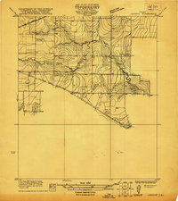
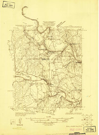
 1921 Spur Creek1921 Print · USGSBallinger and the surrounding Runnels County countryside are captured here in the early 1920s during a period of established riverfront settlement. Genealogists can locate old family-named sites and rural institutions like Big Rock School, Dry Ridge School, and the Gulf Colorado and Santa Fe rail line.
 - 1921 Map of Rowena
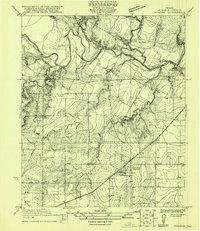 1921 Rowena1921 Print · USGSRunnels County at the start of the 1920s is captured here as a landscape of rural schools and rail-side growth. Genealogists can locate family lands near Rowena and trace the paths to Cross Roads School or Valley Creek School.
 - 1925 Map of Ballinger 3-d
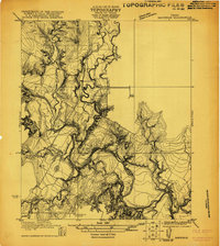
 1925 Ballinger 3-d1925 Print · USGSThe convergence of the Colorado and Concho Rivers is captured here in the mid-1920s as ranching life centered on the water. Local historians can locate river crossings like Hall Ford and rural educational sites such as Mapes School and Currie School.
 - 1925 Map of Ballinger 4-c
 1925 Ballinger 4-c1925 Print · USGSCentral West Texas river valleys are surveyed in the mid-1920s at the junction of three counties. Researchers can locate early rural landmarks like Liberty School and historic river crossings such as Coffee Ford and Trap Crossing.
End of results
Showing maps 1-9 of 9
Top cities of Runnels County
Frequently asked questions
- What are the different types of historical maps available for Runnels County?
- What is the oldest map of Runnels County?
- Where can I purchase historical maps of Runnels County for my home or office?
- Where can I download high-res historical maps of Runnels County?
- Are there historical topographic maps available for Runnels County?
- Is there historical aerial imagery available for Runnels County?
- Where are historical maps of Runnels County sourced from?