1890s Maps of Runnels County, Texas
Explore 6 historic maps of Runnels County from the 1890s. These maps offer a rare glimpse into what life looked like during the 1890s — showing old roads, neighborhoods, homes, and landmarks that have changed or disappeared over time.
Whether you're researching your family's past, planning a metal detecting trip, or studying how Runnels County's landscape evolved across the 1890s, these high-resolution maps are a powerful tool for exploring the history of this region.
- Focus on a specific era: All maps on this page are from the 1890s, giving you a focused view of this time period.
- See what’s changed: Compare century-old streets, trails, and buildings to today's modern landscape using overlays and satellite layers.
- Research with precision: Use these maps for genealogy, historical research, land use analysis, or educational projects.
- View, download, or print: Maps are fully viewable online in high resolution, and can be downloaded or printed for your own records.
Start exploring Runnels County's history through authentic maps from the 1890s. This is your window into the past.
Runnels County, TX maps
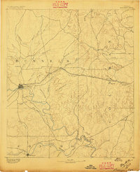
(6)- 1890 Map of Abilene, 1955 Print
 1890 Abilene1955 Print · USGSWest Texas ranching country and rail settlements come alive in the 1890s as the railroad transforms the prairie. Genealogists can trace early homesteads near Buffalo Gap or follow the Texas and Pacific Railway through Abilene and Elmdale.
 - 1891 Map of Hayrick
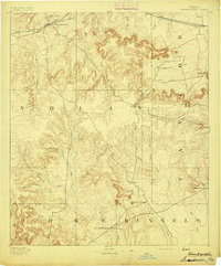
 1891 Hayrick1891 Print · USGSTexas ranching country and the arrival of the iron horse meet in the 1890s as the Colorado River divides emerging frontier counties. Genealogists and historians can trace the early foundations of Hayrick and Rowena, or locate remote landmarks like Harris Ranch and the Rock Spring School House.
 - 1892 Map of Abilene
 1892 Abilene1892 Print · USGSTaylor and Callahan counties were transitioning into a major rail and ranching corridor during the 1890s. Genealogical researchers can locate early frontier settlements like Buffalo Gap and Guion, or trace the path of the Texas and Pacific Railway.5 unique versions available
 - 1892 Map of Ballinger
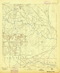
 1892 Ballinger1892 Print · USGSCentral West Texas was a landscape of budding rail towns and winding river valleys in the early 1890s. Genealogists can trace the early footprints of Ballinger and Paintrock or locate smaller vanished points like Norwood and Trap Crossing.5 unique versions available
 - 1893 Map of Sweetwater
 1893 Sweetwater1893 Print · USGSNolan and Taylor counties come alive in the 1890s as the railroad fuels the growth of frontier cattle towns. Genealogists and historians can trace the early streets of Sweetwater and Merkel or locate the historic site of Fort Chadbourne near Church Mountain.4 unique versions available
 - 1894 Map of Hayrick
 1894 Hayrick1894 Print · USGSWest Texas ranching and rail life come into focus in the 1890s as the frontier gives way to established counties and communities. Researchers can trace early family outposts like Harris Ranch, rural education at Rock Spring School House, and the arrival of the Gulf Colorado and Santa Fe Railway.5 unique versions available
End of results
Showing maps 1-6 of 6
Top cities of Runnels County
Frequently asked questions
- What are the different types of historical maps available for Runnels County?
- What is the oldest map of Runnels County?
- Where can I purchase historical maps of Runnels County for my home or office?
- Where can I download high-res historical maps of Runnels County?
- Are there historical topographic maps available for Runnels County?
- Is there historical aerial imagery available for Runnels County?
- Where are historical maps of Runnels County sourced from?