1930s Maps of Runnels County, Texas
Explore 2 historic maps of Runnels County from the 1930s. These maps offer a rare glimpse into what life looked like during the 1930s — showing old roads, neighborhoods, homes, and landmarks that have changed or disappeared over time.
Whether you're researching your family's past, planning a metal detecting trip, or studying how Runnels County's landscape evolved across the 1930s, these high-resolution maps are a powerful tool for exploring the history of this region.
- Focus on a specific era: All maps on this page are from the 1930s, giving you a focused view of this time period.
- See what’s changed: Compare century-old streets, trails, and buildings to today's modern landscape using overlays and satellite layers.
- Research with precision: Use these maps for genealogy, historical research, land use analysis, or educational projects.
- View, download, or print: Maps are fully viewable online in high resolution, and can be downloaded or printed for your own records.
Start exploring Runnels County's history through authentic maps from the 1930s. This is your window into the past.
Runnels County, TX maps
(2)- 1932 Map of Voss
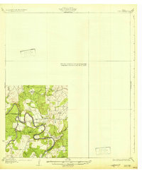 1932 Voss1932 Print · USGSCentral Texas river life in the mid-1920s is documented here along the winding banks of the Concho River. Genealogists and local historians can trace the community of Leaday and several rural schoolhouses like Liberty Sch and Redwire Sch.2 unique versions available
 - 1932 Map of Paint Rock
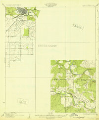 1932 Paint Rock1932 Print · USGSThe northern edge of the Edwards Plateau comes into focus in the early 1930s as the rail lines reached into Concho County. Genealogists and historians can trace the rural school districts of the day, including Dry Ridge Sch and Mapes Sch, or locate the family-named bluffs along the Concho River.2 unique versions available
End of results
Showing maps 1-2 of 2
Top cities of Runnels County
Frequently asked questions
- What are the different types of historical maps available for Runnels County?
- What is the oldest map of Runnels County?
- Where can I purchase historical maps of Runnels County for my home or office?
- Where can I download high-res historical maps of Runnels County?
- Are there historical topographic maps available for Runnels County?
- Is there historical aerial imagery available for Runnels County?
- Where are historical maps of Runnels County sourced from?