1960s Maps of San Saba County, Texas
Explore 4 historic maps of San Saba County from the 1960s. These maps offer a rare glimpse into what life looked like during the 1960s — showing old roads, neighborhoods, homes, and landmarks that have changed or disappeared over time.
Whether you're researching your family's past, planning a metal detecting trip, or studying how San Saba County's landscape evolved across the 1960s, these high-resolution maps are a powerful tool for exploring the history of this region.
- Focus on a specific era: All maps on this page are from the 1960s, giving you a focused view of this time period.
- See what’s changed: Compare century-old streets, trails, and buildings to today's modern landscape using overlays and satellite layers.
- Research with precision: Use these maps for genealogy, historical research, land use analysis, or educational projects.
- View, download, or print: Maps are fully viewable online in high resolution, and can be downloaded or printed for your own records.
Start exploring San Saba County's history through authentic maps from the 1960s. This is your window into the past.
San Saba County, TX maps
(4)- 1962 Map of Fredonia, 1965 Print
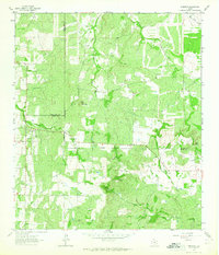 1962 Fredonia1965 Print · USGSThe ranchlands of the Texas Hill Country meet at the three-county junction of Mason, McCulloch, and San Saba in the early 1960s. Genealogists and local historians can trace the rural landscape of Fredonia, finding the Union Band Ch and family sites near Deer Creek Cem.2 unique versions available
 - 1963 Map of Pecan Springs, 1964 Print
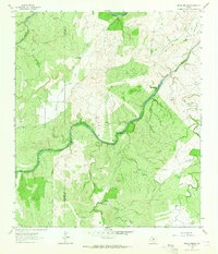 1963 Pecan Springs1964 Print · USGSRanching and river life define the McCulloch and San Saba county line during the early sixties. Genealogists and historians can trace family-named landmarks and essential water sources like Pecan Springs, Sperrell Ranch, and the winding Horseshoe Bend of the San Saba River.2 unique versions available
 - 1963 Map of Lost Creek, 1964 Print
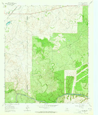 1963 Lost Creek1964 Print · USGSSan Saba and McCulloch counties are captured here in the early sixties, showing a landscape of working ranch land and winding creek beds. Researchers can trace the Gulf Colorado and Santa Fe rail line or locate landmarks like Camp Billy Gibbons and Plum Hollow.2 unique versions available
 - 1967 Map of Tow, 1970 Print
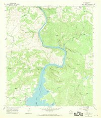 1967 Tow1970 Print · USGSThe northern shores of Lake Buchanan and the Texas Hill Country are documented in the late 1960s. Researchers can locate the Tow settlement and Tow Cem, or trace early river crossings like the Tanyard Crossing (Historic).3 unique versions available
End of results
Showing maps 1-4 of 4
Top cities of San Saba County
Frequently asked questions
- What are the different types of historical maps available for San Saba County?
- What is the oldest map of San Saba County?
- Where can I purchase historical maps of San Saba County for my home or office?
- Where can I download high-res historical maps of San Saba County?
- Are there historical topographic maps available for San Saba County?
- Is there historical aerial imagery available for San Saba County?
- Where are historical maps of San Saba County sourced from?