1970s Maps of San Saba County, Texas
Explore 4 historic maps of San Saba County from the 1970s. These maps offer a rare glimpse into what life looked like during the 1970s — showing old roads, neighborhoods, homes, and landmarks that have changed or disappeared over time.
Whether you're researching your family's past, planning a metal detecting trip, or studying how San Saba County's landscape evolved across the 1970s, these high-resolution maps are a powerful tool for exploring the history of this region.
- Focus on a specific era: All maps on this page are from the 1970s, giving you a focused view of this time period.
- See what’s changed: Compare century-old streets, trails, and buildings to today's modern landscape using overlays and satellite layers.
- Research with precision: Use these maps for genealogy, historical research, land use analysis, or educational projects.
- View, download, or print: Maps are fully viewable online in high resolution, and can be downloaded or printed for your own records.
Start exploring San Saba County's history through authentic maps from the 1970s. This is your window into the past.
San Saba County, TX maps
(4)- 1979 Map of Elm Grove, 1980 Print
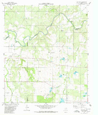 1979 Elm Grove1980 Print · USGSThe ranchlands of San Saba, McCulloch, and Brown counties come into focus in the late 1970s as the Colorado River meanders through the brushy hills. Researchers can locate the Beasley Cemetery, the Elm Grove Ch, and the rural Rodeo Ground.
 - 1979 Map of Richland Springs, 1980 Print
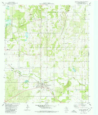 1979 Richland Springs1980 Print · USGSRichland Springs was a vital rail and ranching center in the late seventies, where the Santa Fe line met a rugged terrain of limestone hills. Local historians can trace family roots at Shiloh Cemetery or locate old community landmarks like Skeeterville and the Lakeview Community Hall.
 - 1979 Map of Hall, 1980 Print
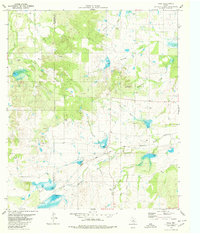 1979 Hall1980 Print · USGSSan Saba and McCulloch counties are captured in the late seventies, showing a landscape defined by ranching and the railroad. Genealogists can locate family landmarks like Cowboy Cem and trace the Atchison Topeka and Santa Fe line through Hall.
 - 1979 Map of Big Valley South, 1980 Print
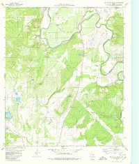 1979 Big Valley South1980 Print · USGSThe Colorado River valley at the San Saba and Mills county line shows a landscape of ranching and river bends in the late seventies. Researchers can trace family origins at the Lower Valley Cem or navigate the terrain around Wildhorse Mountain and Blue Bluff.
End of results
Showing maps 1-4 of 4
Top cities of San Saba County
Frequently asked questions
- What are the different types of historical maps available for San Saba County?
- What is the oldest map of San Saba County?
- Where can I purchase historical maps of San Saba County for my home or office?
- Where can I download high-res historical maps of San Saba County?
- Are there historical topographic maps available for San Saba County?
- Is there historical aerial imagery available for San Saba County?
- Where are historical maps of San Saba County sourced from?