1920s Maps of Stonewall County, Texas
Explore 4 historic maps of Stonewall County from the 1920s. These maps offer a rare glimpse into what life looked like during the 1920s — showing old roads, neighborhoods, homes, and landmarks that have changed or disappeared over time.
Whether you're researching your family's past, planning a metal detecting trip, or studying how Stonewall County's landscape evolved across the 1920s, these high-resolution maps are a powerful tool for exploring the history of this region.
- Focus on a specific era: All maps on this page are from the 1920s, giving you a focused view of this time period.
- See what’s changed: Compare century-old streets, trails, and buildings to today's modern landscape using overlays and satellite layers.
- Research with precision: Use these maps for genealogy, historical research, land use analysis, or educational projects.
- View, download, or print: Maps are fully viewable online in high resolution, and can be downloaded or printed for your own records.
Start exploring Stonewall County's history through authentic maps from the 1920s. This is your window into the past.
Stonewall County, TX maps
(4)- 1925 Map of Aspermont 4-a
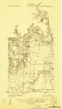 1925 Aspermont 4-a1925 Print · USGSThe community of Old Glory and the banks of the Salt Fork of Brazos River are captured here during the mid-1920s. Genealogists can trace rural family life through the locations of the Grand View Church, New Hope School, and Hooker School.
 - 1925 Map of Haskell 3-b
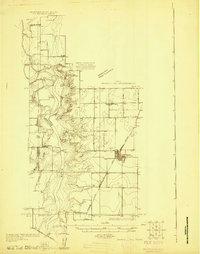 1925 Haskell 3-b1925 Print · USGSSettlement in West Texas during the mid-twenties is centered on the railroad town of Rule and the winding Brazos River. Researchers can trace rural school locations like Rhody School and Cook Springs School or the old path of the Kansas City Mexico and Orient rail line.
 - 1926 Map of Snyder 1-a
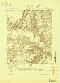 1926 Snyder 1-a1926 Print · USGSWest Texas ranching country and the Brazos watershed are captured here in the mid-twenties, showing where three counties converge. Researchers can trace early roads like the Canadian Highway and locate rural landmarks such as the County Line School.
 - 1926 Map of Roby 2-b
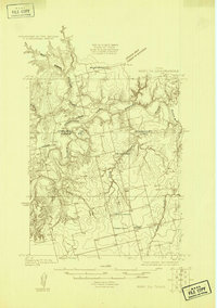 1926 Roby 2-b1926 Print · USGSFisher and Stonewall Counties in the late 1920s are defined by the winding forks of the Brazos River and the remote schoolhouses of the West Texas plains. Researchers can locate family landmarks like the Dowell Cemetery, Wright School, and the rural Dowell Church.
End of results
Showing maps 1-4 of 4
Top cities of Stonewall County
Frequently asked questions
- What are the different types of historical maps available for Stonewall County?
- What is the oldest map of Stonewall County?
- Where can I purchase historical maps of Stonewall County for my home or office?
- Where can I download high-res historical maps of Stonewall County?
- Are there historical topographic maps available for Stonewall County?
- Is there historical aerial imagery available for Stonewall County?
- Where are historical maps of Stonewall County sourced from?