1930s Maps of Stonewall County, Texas
Explore 3 historic maps of Stonewall County from the 1930s. These maps offer a rare glimpse into what life looked like during the 1930s — showing old roads, neighborhoods, homes, and landmarks that have changed or disappeared over time.
Whether you're researching your family's past, planning a metal detecting trip, or studying how Stonewall County's landscape evolved across the 1930s, these high-resolution maps are a powerful tool for exploring the history of this region.
- Focus on a specific era: All maps on this page are from the 1930s, giving you a focused view of this time period.
- See what’s changed: Compare century-old streets, trails, and buildings to today's modern landscape using overlays and satellite layers.
- Research with precision: Use these maps for genealogy, historical research, land use analysis, or educational projects.
- View, download, or print: Maps are fully viewable online in high resolution, and can be downloaded or printed for your own records.
Start exploring Stonewall County's history through authentic maps from the 1930s. This is your window into the past.
Stonewall County, TX maps
(3)- 1931 Map of Rotan
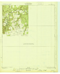 1931 Rotan1931 Print · USGSNorthwest Texas cattle and farming country comes into focus in the early 1930s as regional highways began to trace the hills. Genealogists can locate family landmarks like Dowell Ch and the neighboring Dorras Sch near the Stonewall and Fisher County line.2 unique versions available
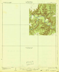
 - 1931 Map of Aspermont
 1931 Aspermont1931 Print · USGSStonewall County in the mid-1920s was a landscape of river breaks and quiet prairie crossroads. You can trace early family settlements and rural life through named landmarks like Old Glory, Grand View Ch, and the many river crossings such as Redhorse Crossing.2 unique versions available
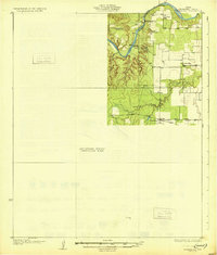
 - 1932 Map of Camp Springs
 1932 Camp Springs1932 Print · USGSIn the 1930s, the borderlands of Kent and Fisher Counties featured a deeply dissected landscape carved by the Double Mountain Fork Brazos River. Local historians can trace the rural landscape of the era through landmarks like the County Line Sch and the expanse of Longhorn Valley.2 unique versions available
End of results
Showing maps 1-3 of 3
Top cities of Stonewall County
Frequently asked questions
- What are the different types of historical maps available for Stonewall County?
- What is the oldest map of Stonewall County?
- Where can I purchase historical maps of Stonewall County for my home or office?
- Where can I download high-res historical maps of Stonewall County?
- Are there historical topographic maps available for Stonewall County?
- Is there historical aerial imagery available for Stonewall County?
- Where are historical maps of Stonewall County sourced from?