1980s Maps of Taylor County, Texas
Explore 15 historic maps of Taylor County from the 1980s. These maps offer a rare glimpse into what life looked like during the 1980s — showing old roads, neighborhoods, homes, and landmarks that have changed or disappeared over time.
Whether you're researching your family's past, planning a metal detecting trip, or studying how Taylor County's landscape evolved across the 1980s, these high-resolution maps are a powerful tool for exploring the history of this region.
- Focus on a specific era: All maps on this page are from the 1980s, giving you a focused view of this time period.
- See what’s changed: Compare century-old streets, trails, and buildings to today's modern landscape using overlays and satellite layers.
- Research with precision: Use these maps for genealogy, historical research, land use analysis, or educational projects.
- View, download, or print: Maps are fully viewable online in high resolution, and can be downloaded or printed for your own records.
Start exploring Taylor County's history through authentic maps from the 1980s. This is your window into the past.
Taylor County, TX maps
(15)- 1984 Map of Merkel West
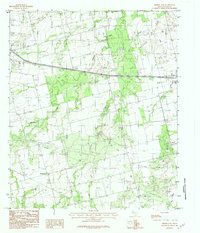
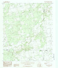
 1984 Merkel West1984 Print · USGSWest Texas ranching and oil infrastructure meet in the late 1970s between the settlements of Merkel and Trent. Trace the rugged elevations of Blowout Mountain and the winding path of Mulberry Canyon alongside landmarks like Rodeo Dr.
 - 1984 Map of Noodle
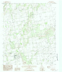 1984 Noodle1984 Print · USGSThe rural landscape of the Texas Big Country in the late seventies is centered on the settlement of Noodle. Genealogists and historians can trace local infrastructure through the Landing Strip, an Oil Field, and old watercourses like Bitter Creek.
 - 1984 Map of Nolan
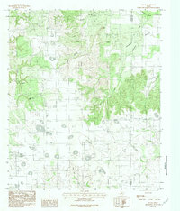 1984 Nolan1984 Print · USGSThe West Texas ranching country around Nolan is captured here during the mid-eighties as it straddles the county line. Researchers can trace the rugged topography from Indian Hand Bluff to the local Cemetery and the winding course of Mulberry Creek.
 - 1984 Map of Merkel East
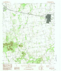
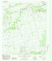
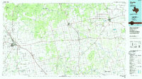
 1984 Merkel East1984 Print · USGSTaylor County during the late seventies and early eighties shows a landscape of growing towns and prairie ranching. Trace local history through family-named sites like Cozart and Mt Pleasant, or locate industrial landmarks including the Oil Field and Military Reservation.2 unique versions available
 - 1984 Map of Stith
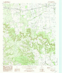
 1984 Stith1984 Print · USGSThe rural boundary between Jones and Taylor counties comes into focus in the late 1970s, centered on the community of Stith. Researchers can trace the winding paths of Bitter Creek and Mulberry Creek or locate the local Cem near the settlement.
 - 1984 Map of Chalk Peak
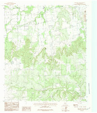
 1984 Chalk Peak1984 Print · USGSThe ranchlands of West Texas come to life in this mid-eighties survey of the Nolan and Taylor county line. Genealogists and local historians can trace family roots at Mulberry Canyon Cem or locate old community sites like Noodle and Herndon.
 - 1984 Map of Mountain Pass
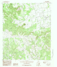
 1984 Mountain Pass1984 Print · USGSTaylor County's rugged ranchland and high mesas are captured here in the late seventies and early eighties. Researchers can trace land use patterns near Nubia, identify the heights of Castle Peak, and locate the seasonal waters of Butman Falls.2 unique versions available
 - 1984 Map of View
 1984 View1984 Print · USGSTaylor County ranch lands meet the limestone heights of the south in the mid-1980s. Genealogists and hikers can trace the geography around the settlement of View, identifying landmarks from Castle Peak to the rural Cem and the winding path of Little Elm Creek.2 unique versions available
 - 1984 Map of Raven Creek South
 1984 Raven Creek South1984 Print · USGSFisher County ranchlands meet the borders of Jones, Nolan, and Taylor counties in the mid-1980s. Genealogists and land researchers can trace property locations along Sweetwater Creek, Raven Creek, and the uniquely named Stink Creek.
 - 1984 Map of Buffalo Gap
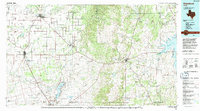
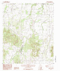 1984 Buffalo Gap1984 Print · USGSIn the mid-eighties, the hills of Taylor County show the early reach of Abilene's expansion toward Buffalo Gap. You can trace rural landmarks from Abilene State Park to the Cedar Gap crossing, along with local Gravel Pits and a Cem.2 unique versions available
 - 1984 Map of Potosi, 1992 Print
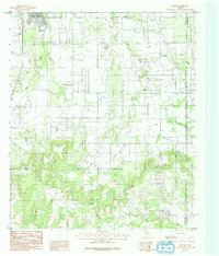 1984 Potosi1992 Print · USGSPotosi and the rural landscape east of Abilene are captured here in the late seventies and early eighties. Genealogists and historians can trace the creek-side settlements along Spring Creek and Lytle Creek, and locate the numerous Oil Wells near Lytle Cove.
 - 1985 Map of Sweetwater
 1985 Sweetwater1985 Print · USGSNolan County and the surrounding ranchlands are shown during the mid-eighties as the local economy balanced rail transport and energy production. Researchers can trace the path of the Missouri Pacific RR through Roscoe or locate rural landmarks like Ft Chadbourne and the Bauman School.2 unique versions available
 - 1985 Map of Snyder
 1985 Snyder1985 Print · USGSMid-1980s Scurry and Fisher Counties are captured here as a landscape of rail-driven commerce and river-bottom agriculture. Researchers can trace the pathways of the Missouri Pacific railroad or locate family-named landmarks like Mc Caulley and Hermleigh.2 unique versions available
 - 1985 Map of Abilene, 1986 Print
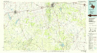
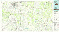 1985 Abilene1986 Print · USGSThe West Texas ranching and rail landscape around Abilene is captured here in the mid-1980s. Local researchers can trace the growth of Hardin-Simmons University, locate family sites near Ross Cem, or explore the area around Buffalo Gap and Dyess Air Force Base.2 unique versions available
 - 1985 Map of Stamford, 1992 Print
 1985 Stamford1992 Print · USGSMid-century West Texas comes alive in this survey of the Brazos River country, showing a landscape defined by oil production and rail transport. Researchers can locate family landmarks like the Avoca Sch, New Hope Ch, and the frontier history at Fort Griffin State Park.
End of results
Showing maps 1-15 of 15
Top cities of Taylor County
- Abilene historical maps
- Merkel historical maps
- Tye historical maps
- Tuscola historical maps
- Buffalo Gap historical maps
- Lawn historical maps
See more
Frequently asked questions
- What are the different types of historical maps available for Taylor County?
- What is the oldest map of Taylor County?
- Where can I purchase historical maps of Taylor County for my home or office?
- Where can I download high-res historical maps of Taylor County?
- Are there historical topographic maps available for Taylor County?
- Is there historical aerial imagery available for Taylor County?
- Where are historical maps of Taylor County sourced from?