1950s Maps of Travis County, Texas
Explore 15 historic maps of Travis County from the 1950s. These maps offer a rare glimpse into what life looked like during the 1950s — showing old roads, neighborhoods, homes, and landmarks that have changed or disappeared over time.
Whether you're researching your family's past, planning a metal detecting trip, or studying how Travis County's landscape evolved across the 1950s, these high-resolution maps are a powerful tool for exploring the history of this region.
- Focus on a specific era: All maps on this page are from the 1950s, giving you a focused view of this time period.
- See what’s changed: Compare century-old streets, trails, and buildings to today's modern landscape using overlays and satellite layers.
- Research with precision: Use these maps for genealogy, historical research, land use analysis, or educational projects.
- View, download, or print: Maps are fully viewable online in high resolution, and can be downloaded or printed for your own records.
Start exploring Travis County's history through authentic maps from the 1950s. This is your window into the past.
Travis County, TX maps
(15)- 1950 Map of Bastrop
 1950 Bastrop1950 Print · USGSThe Colorado River valley around the turn of the decade is defined by sprawling military infrastructure and tight-knit farming communities. Researchers can trace the heritage of Bastrop and Sayersville or locate family landmarks like Burleson Cem and Union Hill Sch.
 - 1950 Map of Elgin
 1950 Elgin1950 Print · USGSMid-century Elgin and the surrounding blackland prairies are shown here just as the local rail and brick industries were peaking. Researchers can trace family roots through numerous local sites like Youngs Prairie Cem, Coupland, and the Brickyards at Butler.
 - 1951 Map of Round Rock
 1951 Round Rock1951 Print · USGSWilliamson County at mid-century reveals a landscape of thriving rural communities and intersecting rail lines before the era of modern suburban expansion. Local researchers can pinpoint family landmarks like Palm Valley Ch, trace the old settlement at Old Round Rock, or locate the Bell Gin.
 - 1954 Map of Austin East, 1956 Print
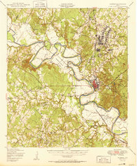
 1954 Austin East1956 Print · USGSMid-century Austin is captured here during a time of significant institutional and residential growth. Genealogists and researchers can trace family landmarks like Oakwood Cemetery, the Fiskville Cemetery, and old schools like Anderson High Sch.
 - 1954 Map of Austin West, 1956 Print
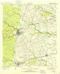
 1954 Austin West1956 Print · USGSMid-century Austin is captured here as the city expanded westward toward the hills and the winding Colorado River. Researchers can trace the layout of Camp Mabry, the historic Texas Confederate Home, and the original footprint of Zilker Park near Barton Springs.
 - 1954 Map of Llano, 1964 Print
 1954 Llano1964 Print · USGSThe Texas Hill Country and Highland Lakes appear in the mid-fifties, just as new reservoirs began reshaping the landscape. Trace ranching history and river routes from Mason to Llano, or follow the Gulf Colorado and Santa Fe RR past Buchanan Lake.2 unique versions available
 - 1954 Map of Austin, 1964 Print
 1954 Austin1964 Print · USGSCentral Texas is captured during a period of steady growth as the capital city and its neighboring farm towns began to modernize. Researchers can trace historic rail corridors like the Southern Pacific RR or locate landmarks such as Bergstrom Air Force Base and Pilot Knob.4 unique versions available
 - 1955 Map of Llano
 1955 Llano1955 Print · USGSCentral Texas and the Hill Country are seen here during the mid-1950s growth of the Highland Lakes. Trace old settlements and geologic landmarks from Enchanted Rock and Longhorn Cavern to the small community of Luckenbach.
 - 1955 Map of Montopolis, 1956 Print
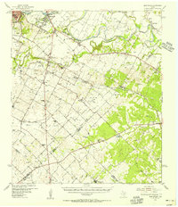
 1955 Montopolis1956 Print · USGSSoutheast Travis County shows its rural roots in the mid-fifties as the capital begins to expand toward the Colorado River. Genealogy researchers can locate family landmarks like Moores Crossing, Pilot Knob Sch, and the historic Salem Ch.2 unique versions available
 - 1955 Map of Oak Hill, 1956 Print
 1955 Oak Hill1956 Print · USGSSouthwest of Austin in the mid-fifties, this area shows a landscape of rural schoolhouses and family farms before the suburban boom. Genealogists can locate family landmarks like the Oak Hill Cem, the St Elmo Sch (Aband), and the Kenchion settlement.
 - 1955 Map of Montopolis, 1956 Print
 1955 Montopolis1956 Print · USGSThe area southeast of Austin in the mid-fifties reveals a transition from river-bottom farming to active resource extraction. Researchers can locate family landmarks such as Assumption Cemetery, the Elroy Oil Field, and rural centers like Moores Crossing.2 unique versions available
 - 1955 Map of Austin, 1956 Print
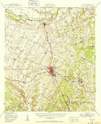
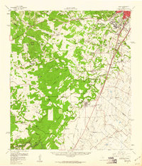
 1955 Austin1956 Print · USGSAustin and its northern Travis County neighbors appear here in the mid-1950s, just as suburban growth began to reach toward the Williamson County line. Researchers can trace historic family locations and vanished institutions like the Travis County Tuberculosis Sanitarium, McNeil, and New Sweden.
 - 1956 Map of Llano, 1976 Print
 1956 Llano1976 Print · USGSThe Texas Hill Country comes alive in this mid-seventies survey of the Llano Uplift and Colorado River lakes. Genealogists and historians can trace family roots through settlements like Luckenbach and Castell or locate the famed L B J Ranch and Enchanted Rock.
 - 1958 Map of Buda, 1960 Print
 1958 Buda1960 Print · USGSBuda and the southern reaches of Travis and Hays Counties are seen here in the late fifties during a period of steady ranching and early suburban growth. Genealogists and local historians can trace family ranch lands and historic sites like Science Hall, Goforth, and the Old San Antonio Road.2 unique versions available
 - 1959 Map of Lake Travis, 1960 Print
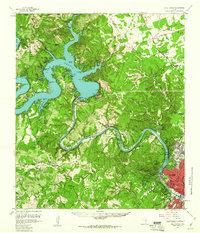 1959 Lake Travis1960 Print · USGSThe Texas Hill Country and the Highland Lakes are captured here during a period of steady growth and ranching. Genealogists can trace early landmarks and family sites like Pond Springs Cem, the Trading Post near Bee Cave, and Schulze Ranch.5 unique versions available
End of results
Showing maps 1-15 of 15
Top cities of Travis County
- Austin historical maps
- Pflugerville historical maps
- Lakeway historical maps
- Manor historical maps
- Lago Vista historical maps
- Bee Cave historical maps
See more
Frequently asked questions
- What are the different types of historical maps available for Travis County?
- What is the oldest map of Travis County?
- Where can I purchase historical maps of Travis County for my home or office?
- Where can I download high-res historical maps of Travis County?
- Are there historical topographic maps available for Travis County?
- Is there historical aerial imagery available for Travis County?
- Where are historical maps of Travis County sourced from?