1900s (20th Century) Maps of Travis County, Texas
Explore 83 historic maps of Travis County from the 1900s (20th Century). These maps offer a rare glimpse into what life looked like during the 1900s — showing old roads, neighborhoods, homes, and landmarks that have changed or disappeared over time.
Whether you're researching your family's past, planning a metal detecting trip, or studying how Travis County's landscape evolved across the 1900s, these high-resolution maps are a powerful tool for exploring the history of this region.
- Focus on a specific era: All maps on this page are from the 1900s, giving you a focused view of this time period.
- See what’s changed: Compare century-old streets, trails, and buildings to today's modern landscape using overlays and satellite layers.
- Research with precision: Use these maps for genealogy, historical research, land use analysis, or educational projects.
- View, download, or print: Maps are fully viewable online in high resolution, and can be downloaded or printed for your own records.
Start exploring Travis County's history through authentic maps from the 1900s. This is your window into the past.
Travis County, TX maps
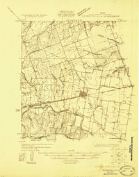
(83)- 1903 Map of Burnet
 1903 Burnet1903 Print · USGSThe Texas Hill Country at the turn of the century shows a landscape of river-side industry and early rail expansion. Trace the historic Houston and Texas Central Railroad line through Burnet and Bertram or locate long-standing landmarks like Morman Mill and Tanyard Crossing.
 - 1904 Map of Bastrop
 1904 Bastrop1904 Print · USGSBastrop and Smithville thrive along the Colorado River at the turn of the century, serving as vital hubs for the Texas interior. Trace ancestral roots and old transport routes through Nashs Ferry, the Coal Mine near Sayersville, and Colorado Chapel.3 unique versions available
 - 1909 Map of Burnet
 1909 Burnet1909 Print · USGSThe Texas Hill Country at the turn of the century shows a landscape of river crossings and rail towns before the creation of the Highland Lakes. Genealogists can locate family-named landmarks like Morman Mill, Tumlinson, and rural schoolhouses such as Berry School or Sunny Lane.3 unique versions available
 - 1910 Map of Austin
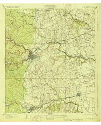
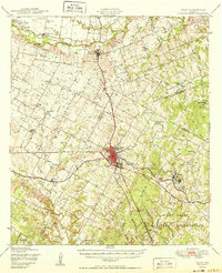
 1910 Austin1910 Print · USGSAustin and the surrounding Travis County hill country are captured here at the start of the twentieth century. Genealogists and researchers can locate pioneer landmarks like Anderson Mill, Mc.Kinney Falls, and numerous river crossings including Lohmann Ford.3 unique versions available
 - 1925 Map of Georgetown 4-d
 1925 Georgetown 4-d1925 Print · USGSWilliamson County in the mid-1920s shows a landscape of developing prairie towns and rural cotton gins. Genealogists can trace early homesteads and landmarks like Stony Point School, Bell Gin, and the historic Hutto townsite.
 - 1928 Map of Round Rock
 1928 Round Rock1928 Print · USGSWilliamson County in the mid-twenties shows a landscape of developing rail hubs and scattered rural school districts. Genealogists can locate family landmarks like Bell Gin, Old Round Rock, and the Strickland Grove Church.2 unique versions available
 - 1930 Map of Austin-2
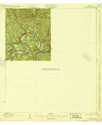
 1930 Austin-21930 Print · USGSThe winding loops of the Colorado River dominate this 1930 survey of Travis County before the era of major dams. Researchers can trace early crossings like Stewart Ford and locate local landmarks such as the Jack Sch and Ch.
 - 1930 Map of Blanco-1
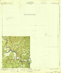
 1930 Blanco-11930 Print · USGSCentral Texas river valleys appear in high detail during the early 1930s, showing the landscape before later reservoir projects. Trace the original paths of the Colorado River and Pedernales River past Pleasant Grove Sch and Buggy Ford.
 - 1932 Map of Mt. Bonnell
 1932 Mt. Bonnell1932 Print · USGSThe meanders of the Texas Hill Country are captured here in the early 1930s, just before the landscape was transformed by dam construction. You can trace early river life through multiple historical crossings like Lohmann Ford and rural sites like Cox Spring Sch.2 unique versions available
 - 1932 Map of Bertram
 1932 Bertram1932 Print · USGSBurnet County’s river-bound landscape is documented here in the early 1930s, featuring the rural life of Smithwick and the winding COLORADO RIVER. Genealogists can trace family footprints at Pleasant Valley Sch, Hale Ch, and historic river fords like SINGLETON CROSSING.2 unique versions available
 - 1948 Map of Elgin, 1969 Print
 1948 Elgin1969 Print · USGSCentral Texas in the late 1940s was a landscape of rail-junction towns and emerging military training grounds. Genealogists can trace rural family legacies through sites like Youngs Prairie Cem, the Camp Swift Military Reservation, and Red Town Sch.2 unique versions available
 - 1948 Map of Bastrop, 1972 Print
 1948 Bastrop1972 Print · USGSBastrop and its winding river bends are captured here in the late 1940s as the military and oil industries integrated with rural farming life. Trace the footprints of the Camp Swift Military Reservation or locate family sites at Bartons Farm, Woods Cem, and Shiloh Sch.
 - 1949 Map of Round Rock, 1967 Print
 1949 Round Rock1967 Print · USGSCentral Texas in the late 1940s reveals a landscape defined by cotton ginning and the heavy influence of competing rail lines. Genealogists can locate family landmarks like Palm Valley Ch, the Bell Gin, and rural schools such as Palacky Sch or Bell Sch.2 unique versions available
 - 1950 Map of Bastrop
 1950 Bastrop1950 Print · USGSThe Colorado River valley around the turn of the decade is defined by sprawling military infrastructure and tight-knit farming communities. Researchers can trace the heritage of Bastrop and Sayersville or locate family landmarks like Burleson Cem and Union Hill Sch.
 - 1950 Map of Elgin
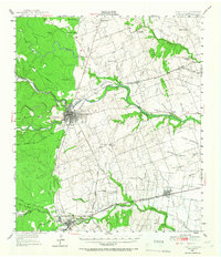
 1950 Elgin1950 Print · USGSMid-century Elgin and the surrounding blackland prairies are shown here just as the local rail and brick industries were peaking. Researchers can trace family roots through numerous local sites like Youngs Prairie Cem, Coupland, and the Brickyards at Butler.
 - 1951 Map of Round Rock
 1951 Round Rock1951 Print · USGSWilliamson County at mid-century reveals a landscape of thriving rural communities and intersecting rail lines before the era of modern suburban expansion. Local researchers can pinpoint family landmarks like Palm Valley Ch, trace the old settlement at Old Round Rock, or locate the Bell Gin.
 - 1954 Map of Austin East, 1956 Print
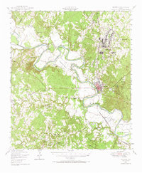
 1954 Austin East1956 Print · USGSMid-century Austin is captured here during a time of significant institutional and residential growth. Genealogists and researchers can trace family landmarks like Oakwood Cemetery, the Fiskville Cemetery, and old schools like Anderson High Sch.
 - 1954 Map of Austin West, 1956 Print
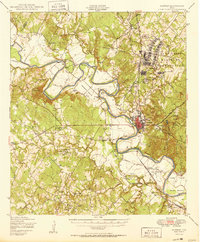
 1954 Austin West1956 Print · USGSMid-century Austin is captured here as the city expanded westward toward the hills and the winding Colorado River. Researchers can trace the layout of Camp Mabry, the historic Texas Confederate Home, and the original footprint of Zilker Park near Barton Springs.
 - 1954 Map of Llano, 1964 Print
 1954 Llano1964 Print · USGSThe Texas Hill Country and Highland Lakes appear in the mid-fifties, just as new reservoirs began reshaping the landscape. Trace ranching history and river routes from Mason to Llano, or follow the Gulf Colorado and Santa Fe RR past Buchanan Lake.2 unique versions available
 - 1954 Map of Austin, 1964 Print
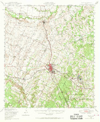
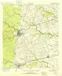
 1954 Austin1964 Print · USGSCentral Texas is captured during a period of steady growth as the capital city and its neighboring farm towns began to modernize. Researchers can trace historic rail corridors like the Southern Pacific RR or locate landmarks such as Bergstrom Air Force Base and Pilot Knob.4 unique versions available
 - 1955 Map of Llano
 1955 Llano1955 Print · USGSCentral Texas and the Hill Country are seen here during the mid-1950s growth of the Highland Lakes. Trace old settlements and geologic landmarks from Enchanted Rock and Longhorn Cavern to the small community of Luckenbach.
 - 1955 Map of Montopolis, 1956 Print
 1955 Montopolis1956 Print · USGSSoutheast Travis County shows its rural roots in the mid-fifties as the capital begins to expand toward the Colorado River. Genealogy researchers can locate family landmarks like Moores Crossing, Pilot Knob Sch, and the historic Salem Ch.2 unique versions available
 - 1955 Map of Oak Hill, 1956 Print
 1955 Oak Hill1956 Print · USGSSouthwest of Austin in the mid-fifties, this area shows a landscape of rural schoolhouses and family farms before the suburban boom. Genealogists can locate family landmarks like the Oak Hill Cem, the St Elmo Sch (Aband), and the Kenchion settlement.
 - 1955 Map of Montopolis, 1956 Print
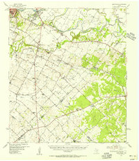 1955 Montopolis1956 Print · USGSThe area southeast of Austin in the mid-fifties reveals a transition from river-bottom farming to active resource extraction. Researchers can locate family landmarks such as Assumption Cemetery, the Elroy Oil Field, and rural centers like Moores Crossing.2 unique versions available
 - 1955 Map of Austin, 1956 Print
 1955 Austin1956 Print · USGSAustin and its northern Travis County neighbors appear here in the mid-1950s, just as suburban growth began to reach toward the Williamson County line. Researchers can trace historic family locations and vanished institutions like the Travis County Tuberculosis Sanitarium, McNeil, and New Sweden.
Showing maps 1-25 of 83
Top cities of Travis County
- Austin historical maps
- Pflugerville historical maps
- Lakeway historical maps
- Manor historical maps
- Lago Vista historical maps
- Bee Cave historical maps
See more
Frequently asked questions
- What are the different types of historical maps available for Travis County?
- What is the oldest map of Travis County?
- Where can I purchase historical maps of Travis County for my home or office?
- Where can I download high-res historical maps of Travis County?
- Are there historical topographic maps available for Travis County?
- Is there historical aerial imagery available for Travis County?
- Where are historical maps of Travis County sourced from?