1980s Maps of Wichita County, Texas
Explore 6 historic maps of Wichita County from the 1980s. These maps offer a rare glimpse into what life looked like during the 1980s — showing old roads, neighborhoods, homes, and landmarks that have changed or disappeared over time.
Whether you're researching your family's past, planning a metal detecting trip, or studying how Wichita County's landscape evolved across the 1980s, these high-resolution maps are a powerful tool for exploring the history of this region.
- Focus on a specific era: All maps on this page are from the 1980s, giving you a focused view of this time period.
- See what’s changed: Compare century-old streets, trails, and buildings to today's modern landscape using overlays and satellite layers.
- Research with precision: Use these maps for genealogy, historical research, land use analysis, or educational projects.
- View, download, or print: Maps are fully viewable online in high resolution, and can be downloaded or printed for your own records.
Start exploring Wichita County's history through authentic maps from the 1980s. This is your window into the past.
Wichita County, TX maps
(6)- 1984 Map of Cowboy Springs, 1985 Print
 1984 Cowboy Springs1985 Print · USGSThe Red River borderlands of Tillman County are captured here in the early eighties, showcasing the shifting riverbed and rural industry. Genealogists and historians can trace the Indefinite Boundary and find local sites like Suttle, Cowboy Springs, and various oil wells.
 - 1985 Map of Augur Creek
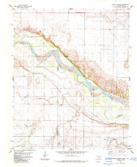
 1985 Augur Creek1985 Print · USGSThe Red River valley along the Oklahoma-Texas border is captured here in the mid-1980s, showing the intersection of river life and prairie agriculture. Researchers can locate the historic Fort Augur (Site) and trace the drainage of Augur Creek and China Creek as they meet the Red River.
 - 1985 Map of Wichita Falls
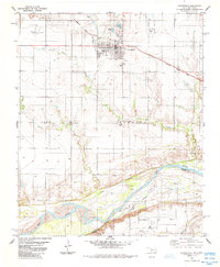
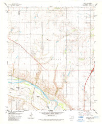
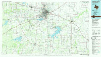 1985 Wichita Falls1985 Print · USGSWichita Falls and the surrounding North Texas oil patches are captured here during a period of established energy production and military importance. Genealogists and historians can trace family-named sites and regional hubs like Sheppard Air Force Base, Electra, and Lake Arrowhead State Park.2 unique versions available
 - 1985 Map of Grandfield
 1985 Grandfield1985 Print · USGSGrandfield and the Tillman County borderlands are shown in the mid-1980s, where the railroad and oil economy meet the Red River. Researchers can trace the path of the Missouri Kansas Texas line or locate family sites near the Cem and Northwest Oil Field.
 - 1985 Map of Devol
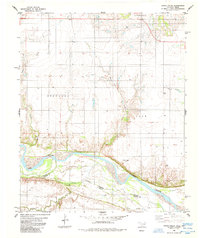
 1985 Devol1985 Print · USGSThe Oklahoma-Texas borderlands come into focus in the mid-1980s, centered on the railroad town of Devol. Researchers can trace the path of the Missouri Kansas Texas line or locate rural Oil Wells and the local Cem.
 - 1985 Map of Burkburnett, 1986 Print
 1985 Burkburnett1986 Print · USGSThe Red River valley and North Texas oil fields are captured here in the mid-eighties, showing the vital connection between military hubs and rail towns. Researchers can trace the path of the Missouri Kansas Texas railroad through Burkburnett or locate Waurika Lake and Sheppard Air Force Base.2 unique versions available
End of results
Showing maps 1-6 of 6
Top cities of Wichita County
- Wichita Falls historical maps
- Burkburnett historical maps
- Iowa Park historical maps
- Electra historical maps
- Pleasant Valley historical maps
- Cashion Community historical maps
Frequently asked questions
- What are the different types of historical maps available for Wichita County?
- What is the oldest map of Wichita County?
- Where can I purchase historical maps of Wichita County for my home or office?
- Where can I download high-res historical maps of Wichita County?
- Are there historical topographic maps available for Wichita County?
- Is there historical aerial imagery available for Wichita County?
- Where are historical maps of Wichita County sourced from?