1960s Maps of Wichita County, Texas
Explore 5 historic maps of Wichita County from the 1960s. These maps offer a rare glimpse into what life looked like during the 1960s — showing old roads, neighborhoods, homes, and landmarks that have changed or disappeared over time.
Whether you're researching your family's past, planning a metal detecting trip, or studying how Wichita County's landscape evolved across the 1960s, these high-resolution maps are a powerful tool for exploring the history of this region.
- Focus on a specific era: All maps on this page are from the 1960s, giving you a focused view of this time period.
- See what’s changed: Compare century-old streets, trails, and buildings to today's modern landscape using overlays and satellite layers.
- Research with precision: Use these maps for genealogy, historical research, land use analysis, or educational projects.
- View, download, or print: Maps are fully viewable online in high resolution, and can be downloaded or printed for your own records.
Start exploring Wichita County's history through authentic maps from the 1960s. This is your window into the past.
Wichita County, TX maps
(5)- 1966 Map of Mankins, 1968 Print
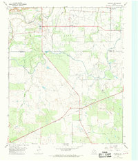 1966 Mankins1968 Print · USGSNorthern Archer County in the mid-sixties is defined by the energy and water infrastructure of the day. Researchers can trace the massive K M A Oil Field and the rail corridors of the Fort Worth and Denver near Mankins.
 - 1966 Map of Holliday, 1968 Print
 1966 Holliday1968 Print · USGSNorth Texas oil and rail culture intersect in the 1960s as industrial development spreads across the Wichita and Archer County line. Genealogists and historians can trace the Fort Worth and Denver line, the Holliday townsite, and several active petroleum zones like the Daume Oil Field.
 - 1966 Map of Lake Diversion, 1968 Print
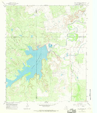 1966 Lake Diversion1968 Print · USGSThe North Texas plains meet the industrial waterworks of the mid-sixties in this survey of the Archer and Wichita county lines. Trace the local economy through petroleum landmarks like the Potts Oil Field and the technical operations at the Dundee Fish Hatchery.
 - 1968 Map of Beaver Creek, 1971 Print
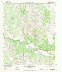 1968 Beaver Creek1971 Print · USGSThe oil-rich borderlands of Wichita and Wilbarger counties are documented here in the late sixties during a period of heavy production. Trace family history and industrial footprints through the Electra Oil Field, Ronda Cem, and Potato Hill.
 - 1968 Map of Fowlkes, 1971 Print
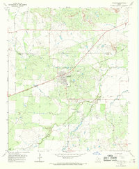
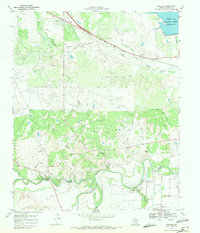 1968 Fowlkes1971 Print · USGSWichita County was a hub of energy and rail transport in the late sixties, centered on the Wichita River valley. Genealogists and industrial historians can locate the Fowlkes settlement, the Fort Worth and Denver line, and the sprawling Electra Oil Field.
End of results
Showing maps 1-5 of 5
Top cities of Wichita County
- Wichita Falls historical maps
- Burkburnett historical maps
- Iowa Park historical maps
- Electra historical maps
- Pleasant Valley historical maps
- Cashion Community historical maps
Frequently asked questions
- What are the different types of historical maps available for Wichita County?
- What is the oldest map of Wichita County?
- Where can I purchase historical maps of Wichita County for my home or office?
- Where can I download high-res historical maps of Wichita County?
- Are there historical topographic maps available for Wichita County?
- Is there historical aerial imagery available for Wichita County?
- Where are historical maps of Wichita County sourced from?