1910s Maps of Wichita County, Texas
Explore 13 historic maps of Wichita County from the 1910s. These maps offer a rare glimpse into what life looked like during the 1910s — showing old roads, neighborhoods, homes, and landmarks that have changed or disappeared over time.
Whether you're researching your family's past, planning a metal detecting trip, or studying how Wichita County's landscape evolved across the 1910s, these high-resolution maps are a powerful tool for exploring the history of this region.
- Focus on a specific era: All maps on this page are from the 1910s, giving you a focused view of this time period.
- See what’s changed: Compare century-old streets, trails, and buildings to today's modern landscape using overlays and satellite layers.
- Research with precision: Use these maps for genealogy, historical research, land use analysis, or educational projects.
- View, download, or print: Maps are fully viewable online in high resolution, and can be downloaded or printed for your own records.
Start exploring Wichita County's history through authentic maps from the 1910s. This is your window into the past.
Wichita County, TX maps
(13)- 1915 Map of Clara, 1961 Print
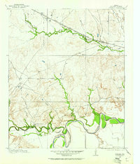
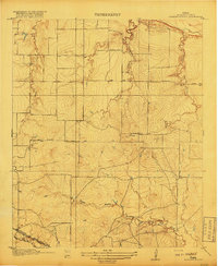
 1915 Clara1961 Print · USGSWichita County was a land of rural schoolhouses and river crossings during the early twentieth century. Researchers can trace the original locations of Fairview School, Wyeth School, and the settlement of Clara along the banks of the Red River.
 - 1915 Map of Barwise School, 1961 Print
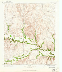
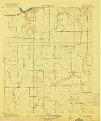
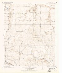 1915 Barwise School1961 Print · USGSWichita County was a landscape of remote school districts and winding prairie creeks during the early years of the twentieth century. Researchers can trace the rural infrastructure of the era through landmarks like Barwise School, the Fort Worth and Denver City rail line, and Tenth Cavalry Creek.
 - 1915 Map of Burkburnett, 1961 Print
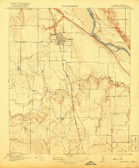
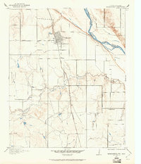 1915 Burkburnett1961 Print · USGSThe Texas-Oklahoma borderlands south of the Red River are shown here in the mid-1910s as rail and road networks began to reshape the frontier. Researchers can trace the early layout of Burkburnett, the location of the Cashion School, and the route of the Wichita Falls and Northwestern railroad.
 - 1916 Map of Electra, 1961 Print
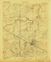
 1916 Electra1961 Print · USGSElectra and the surrounding plains of North Texas are captured here just as the regional oil and rail economy was transforming the landscape. Genealogists and historians can trace the precise locations of the County Line School, Mt Carmel Church, and the Red River School.
 - 1916 Map of Iowa Park, 1961 Print
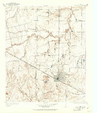
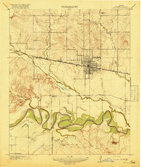
 1916 Iowa Park1961 Print · USGSIowa Park and the surrounding Wichita County prairies are captured here in the early twentieth century, centered on the Fort Worth and Denver City railroad. Researchers can locate vanished rural landmarks like Pond Creek School, Cobb School, and the old Electra Road.
 - 1916 Map of Fowlkes, 1961 Print
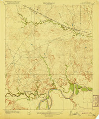
 1916 Fowlkes1961 Print · USGSWichita County was a landscape of rail junctions and river bends during the mid-1910s. Genealogists and historians can trace the early rail corridors of the Fort Worth and Denver City and find rural landmarks like Fowlkes and Rocky Point School.
 - 1917 Map of Beaver Creek, 1961 Print
 1917 Beaver Creek1961 Print · USGSNorth Texas at the end of the Great War was a landscape of remote schoolhouses and creekside chapels near the Wilbarger and Wichita county line. Researchers can locate early rural landmarks like Marvin Chapel, Ronda School, and the namesake Beaver Creek School.
 - 1918 Map of Buckburnett
 1918 Buckburnett1918 Print · USGSWichita County sits on the edge of a historic oil boom during the late nineteen-teens, dominated by the winding Red River border. Genealogists and historians can trace early town plats in Burkburnett, rural landmarks like Cashion School, and the path of the Wichita Falls and Northwestern railroad.3 unique versions available
 - 1918 Map of Electra
 1918 Electra1918 Print · USGSThe North Texas plains near the Wichita-Wilbarger border show a growing network of roads and rural schools during the late nineteen-teens. Researchers can trace early family settlements and local landmarks like Mt Carmel Church, the Enterprise School, and the busy Electra townsite.
 - 1918 Map of Barwise School
 1918 Barwise School1918 Print · USGSWichita County was a landscape of emerging rural school districts and early transit corridors during the First World War. Genealogists and historians can trace the early property lines and routes connecting Barwise School and Sunshine School with the Fort Worth and Denver City Road.2 unique versions available
 - 1918 Map of Clara
 1918 Clara1918 Print · USGSThe North Texas borderlands along the Red River appear here during the height of the early twentieth-century oil boom era. Researchers can locate the early rural settlements of Clara and Stringtown, alongside historic country schoolhouses like Wyeth School.2 unique versions available
 - 1918 Map of Iowa Park
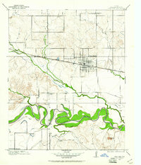
 1918 Iowa Park1918 Print · USGSWichita County was a landscape of small school districts and vital rail links during the late First World War era. Genealogists and historians can trace the foundations of local communities through landmarks like Harmony School, Deep Creek School, and the early town grid of Iowa Park.2 unique versions available
 - 1919 Map of Fowlkes
 1919 Fowlkes1919 Print · USGSWichita County was a landscape of winding river bends and new rail lines during the late nineteen-teens. Genealogists and researchers can locate the Rocky Point School and the remote settlement of Fowlkes along the Fort Worth and Denver City railroad.2 unique versions available
End of results
Showing maps 1-13 of 13
Top cities of Wichita County
- Wichita Falls historical maps
- Burkburnett historical maps
- Iowa Park historical maps
- Electra historical maps
- Pleasant Valley historical maps
- Cashion Community historical maps
Frequently asked questions
- What are the different types of historical maps available for Wichita County?
- What is the oldest map of Wichita County?
- Where can I purchase historical maps of Wichita County for my home or office?
- Where can I download high-res historical maps of Wichita County?
- Are there historical topographic maps available for Wichita County?
- Is there historical aerial imagery available for Wichita County?
- Where are historical maps of Wichita County sourced from?