
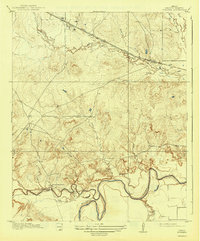
1919 Map of Fowlkes
USGS Topo · Published 1919About this map
Wichita River meanders across the southern portion of this landscape, its banks defined by sharp relief and numerous tributary drainages such as Whiskey Creek and Bolivar Hollow. Surveyed in the years following the region's early oil discoveries, the map reveals a rural infrastructure centered on the Fort Worth and Denver City railroad, which cuts through the northern plains near Fowlkes. This rail corridor provided the primary connection for the area's agricultural and burgeoning industrial interests, including a riverside Pumping Station. Local civic life is anchored by the Rocky Point School, situated on a ridge overlooking the river valley. The topography is characterized by a dense network of seasonal creek beds, including Wolf Creek and South Fork Buffalo Creek, which illustrate the complex erosion patterns of the North Texas plains before widespread modern development altered the drainage and road networks.
Find a feature on this map
18 named features on this map. Tap any name to fly to it.
Don’t see what you’re looking for? This feature index may not catch every label — zoom into the map to look around manually.
Map Details
Editions of this 1919 Fowlkes Map
2 editions found
Other maps of this area

1915 · Clara
USGS Topo · 1:24,000

1915 · Barwise School
USGS Topo · 1:24,000

1916 · Electra
USGS Topo · 1:24,000

1916 · Iowa Park
USGS Topo · 1:24,000

1916 · Fowlkes
USGS Topo · 1:24,000

1917 · Beaver Creek
USGS Topo · 1:24,000

1918 · Electra
USGS Topo · 1:31,680

1918 · Barwise School
USGS Topo · 1:31,680

1918 · Clara
USGS Topo · 1:31,680

1918 · Iowa Park
USGS Topo · 1:31,680