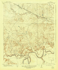
1919 Map of Fowlkes
USGS Topo · Published 1943About this map
The winding Wichita River and its dense network of tributaries anchor this 1916 survey of Wichita County. The landscape is defined by the sharp transition between the river lowlands and the upland drainage systems of Wolf Creek and Deep Creek. In the northern portion of the sheet, the Fort Worth and Denver City Road corridor facilitates transit through the settlement of Fowlkes, running parallel to the Electra rail line. This transportation artery contrasts with the more isolated southern sections, where local life centered around the Rocky Point School and the river. A notable industrial marker is the Pumping Station situated along the riverbank, indicating early water management and infrastructure developments in the region. The map also detail various hollows and forks, such as Bolivar Hollow and South Fork Buffalo Creek, providing a clear view of the topographical grain that influenced early Texas ranching and settlement patterns.
Find a feature on this map
18 named features on this map. Tap any name to fly to it.
Don’t see what you’re looking for? This feature index may not catch every label — zoom into the map to look around manually.
Map Details
Editions of this 1919 Fowlkes Map
2 editions found

Other maps of this area

1915 · Clara
USGS Topo · 1:24,000

1915 · Barwise School
USGS Topo · 1:24,000

1916 · Electra
USGS Topo · 1:24,000

1916 · Iowa Park
USGS Topo · 1:24,000

1916 · Fowlkes
USGS Topo · 1:24,000

1917 · Beaver Creek
USGS Topo · 1:24,000

1918 · Electra
USGS Topo · 1:31,680

1918 · Barwise School
USGS Topo · 1:31,680

1918 · Clara
USGS Topo · 1:31,680

1918 · Iowa Park
USGS Topo · 1:31,680