Old Maps of Wichita County, Texas for Hiking & Exploration
Hike through history with 80 historic maps of Wichita County. Explore old trails, ghost towns, and forgotten backroads — perfect for outdoor adventurers and local explorers.
- Rediscover forgotten places: Map out old mining camps, roads, and footpaths that no longer exist on modern maps.
- Layer with modern tools: Combine with LiDAR or satellite views to plan hikes through historical terrain.
- Made for exploration: Popular among hikers, overlanders, and local history lovers.
Use these maps to find adventure and explore the hidden past of Wichita County.
Wichita County, TX maps
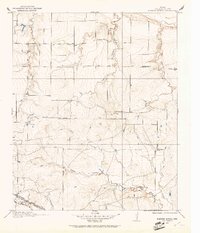
(80)- 1915 Map of Clara, 1961 Print
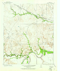
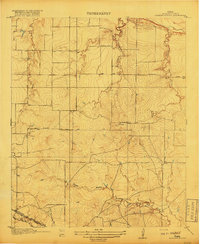
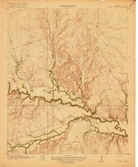
 1915 Clara1961 Print · USGSWichita County was a land of rural schoolhouses and river crossings during the early twentieth century. Researchers can trace the original locations of Fairview School, Wyeth School, and the settlement of Clara along the banks of the Red River.
 - 1915 Map of Barwise School, 1961 Print
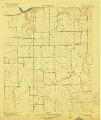
 1915 Barwise School1961 Print · USGSWichita County was a landscape of remote school districts and winding prairie creeks during the early years of the twentieth century. Researchers can trace the rural infrastructure of the era through landmarks like Barwise School, the Fort Worth and Denver City rail line, and Tenth Cavalry Creek.
 - 1915 Map of Burkburnett, 1961 Print
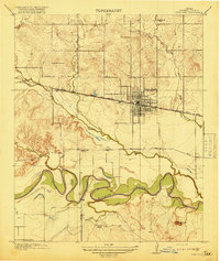
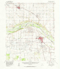
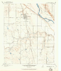 1915 Burkburnett1961 Print · USGSThe Texas-Oklahoma borderlands south of the Red River are shown here in the mid-1910s as rail and road networks began to reshape the frontier. Researchers can trace the early layout of Burkburnett, the location of the Cashion School, and the route of the Wichita Falls and Northwestern railroad.
 - 1916 Map of Electra, 1961 Print
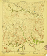
 1916 Electra1961 Print · USGSElectra and the surrounding plains of North Texas are captured here just as the regional oil and rail economy was transforming the landscape. Genealogists and historians can trace the precise locations of the County Line School, Mt Carmel Church, and the Red River School.
 - 1916 Map of Iowa Park, 1961 Print
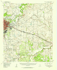
 1916 Iowa Park1961 Print · USGSIowa Park and the surrounding Wichita County prairies are captured here in the early twentieth century, centered on the Fort Worth and Denver City railroad. Researchers can locate vanished rural landmarks like Pond Creek School, Cobb School, and the old Electra Road.
 - 1916 Map of Fowlkes, 1961 Print
 1916 Fowlkes1961 Print · USGSWichita County was a landscape of rail junctions and river bends during the mid-1910s. Genealogists and historians can trace the early rail corridors of the Fort Worth and Denver City and find rural landmarks like Fowlkes and Rocky Point School.
 - 1917 Map of Beaver Creek, 1961 Print
 1917 Beaver Creek1961 Print · USGSNorth Texas at the end of the Great War was a landscape of remote schoolhouses and creekside chapels near the Wilbarger and Wichita county line. Researchers can locate early rural landmarks like Marvin Chapel, Ronda School, and the namesake Beaver Creek School.
 - 1918 Map of Buckburnett
 1918 Buckburnett1918 Print · USGSWichita County sits on the edge of a historic oil boom during the late nineteen-teens, dominated by the winding Red River border. Genealogists and historians can trace early town plats in Burkburnett, rural landmarks like Cashion School, and the path of the Wichita Falls and Northwestern railroad.3 unique versions available
 - 1918 Map of Electra
 1918 Electra1918 Print · USGSThe North Texas plains near the Wichita-Wilbarger border show a growing network of roads and rural schools during the late nineteen-teens. Researchers can trace early family settlements and local landmarks like Mt Carmel Church, the Enterprise School, and the busy Electra townsite.
 - 1918 Map of Barwise School
 1918 Barwise School1918 Print · USGSWichita County was a landscape of emerging rural school districts and early transit corridors during the First World War. Genealogists and historians can trace the early property lines and routes connecting Barwise School and Sunshine School with the Fort Worth and Denver City Road.2 unique versions available
 - 1918 Map of Clara
 1918 Clara1918 Print · USGSThe North Texas borderlands along the Red River appear here during the height of the early twentieth-century oil boom era. Researchers can locate the early rural settlements of Clara and Stringtown, alongside historic country schoolhouses like Wyeth School.2 unique versions available
 - 1918 Map of Iowa Park
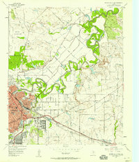
 1918 Iowa Park1918 Print · USGSWichita County was a landscape of small school districts and vital rail links during the late First World War era. Genealogists and historians can trace the foundations of local communities through landmarks like Harmony School, Deep Creek School, and the early town grid of Iowa Park.2 unique versions available
 - 1919 Map of Fowlkes
 1919 Fowlkes1919 Print · USGSWichita County was a landscape of winding river bends and new rail lines during the late nineteen-teens. Genealogists and researchers can locate the Rocky Point School and the remote settlement of Fowlkes along the Fort Worth and Denver City railroad.2 unique versions available
 - 1920 Map of Beaver Creek
 1920 Beaver Creek1920 Print · USGSWichita and Wilbarger counties are captured here just after the Great War, showing a landscape defined by seasonal creek beds and isolated schoolhouses. Researchers can locate early community hubs like Marvin Chapel, Ronda School, and landmarks such as Potato Hill.2 unique versions available
 - 1954 Map of Wichita Falls, 1966 Print
 1954 Wichita Falls1966 Print · USGSNorth Texas in the mid-fifties is captured here as a landscape of expanding oil fields and vital rail corridors. Genealogists and historians can trace family roots through rural landmarks like Bacon Chapel and the rail-side growth of Seymour and Archer City.3 unique versions available
 - 1955 Map of Lawton, 1958 Print
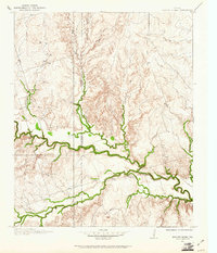
 1955 Lawton1958 Print · USGSSouthwestern Oklahoma and North Texas are shown here in the mid-fifties, dominated by the Wichita Mountains and the vital Red River watershed. Genealogists and historians can trace the foundations of Lawton alongside rural landmarks like Rainy Mountain Church and Pleasant Hill School.5 unique versions available
 - 1956 Map of Sloop Creek, 1957 Print
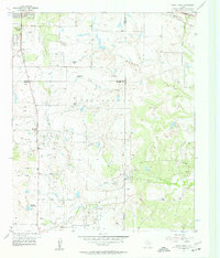 1956 Sloop Creek1957 Print · USGSThis mid-fifties survey of the Archer and Wichita County line shows the intersection of the burgeoning oil industry and traditional ranching. Genealogists and historians can trace family properties like Vogtsberger Ranch or locate the North Star School and Kickapoo Airport.3 unique versions available
 - 1956 Map of Lake Wichita, 1958 Print
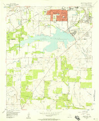 1956 Lake Wichita1958 Print · USGSNorth Texas oil production and suburban growth collide in the mid-1950s as Wichita Falls expands toward the shores of Lake Wichita. Researchers can trace historic property boundaries and industrial sites like the Wichita Falls State Hospitals, Midwestern University, and the Hull-Silk oil field.3 unique versions available
 - 1957 Map of Wichita Falls West, 1958 Print
 1957 Wichita Falls West1958 Print · USGSWichita Falls experienced rapid postwar expansion during the late fifties as suburban life and industrial growth met the Texas plains. Trace the footprints of Midwestern University, the Sheppard Air Force Base, and local landmarks like the Wichita Valley Community House.
 - 1957 Map of Burkburnett, 1958 Print
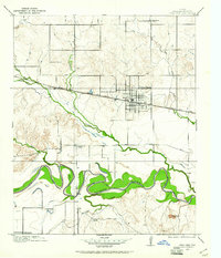
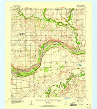
 1957 Burkburnett1958 Print · USGSThe Red River valley in the late fifties was a bustling corridor of oil production and rail transport. Genealogists and historians can trace the foundations of Burkburnett and Grandfield, finding old sites like Clara Ch and the Red River Oil Field.
 - 1957 Map of Randlett, 1958 Print
 1957 Randlett1958 Print · USGSThe Red River borderlands of Oklahoma and Texas come alive in this mid-century survey of the local oil fields and river bottoms. Researchers can trace rural lineages through sites like Randlett Cem, the Linville Sch (Aban'd), and the historical Perkins Reservation.2 unique versions available
 - 1957 Map of Wichita Falls East, 1958 Print
 1957 Wichita Falls East1958 Print · USGSNorth Texas in the late fifties was a landscape of expanding military aviation and established oil fields. Genealogists and historians can trace family-named properties like Vogtsberger Ranch alongside landmarks like White Hill Ch and the Kempner Cem.
 - 1957 Map of Wichita Falls East, 1958 Print
 1957 Wichita Falls East1958 Print · USGSMid-century Wichita Falls shows a landscape of military expansion and ranching heritage along the meanders of the Wichita River. Researchers can trace the development of Sheppard Air Force Base and find family-named properties like 77 Ranch and Hammon Ranch.
 - 1957 Map of Wichita Falls West, 1958 Print
 1957 Wichita Falls West1958 Print · USGSWichita Falls and the surrounding oil fields come into focus during the late fifties as military and industrial growth reshaped the county. Researchers can trace family sites at Highland Cemetery, locate the original campus of Midwestern Univ, and find now-quiet rail stops like Bacon and Hartex.
 - 1958 Map of Wichita Falls
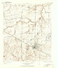
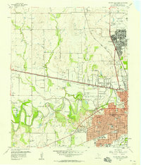
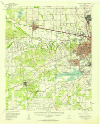
 1958 Wichita Falls1958 Print · USGSNorth Texas during the late fifties reveals a landscape defined by the booming petroleum industry and established rail hubs. Researchers can trace the development of Wichita Falls and discover rural landmarks like Barton's Chapel or the Hull-Silk Oil Field.
Showing maps 1-25 of 80
Top cities of Wichita County
- Wichita Falls historical maps
- Burkburnett historical maps
- Iowa Park historical maps
- Electra historical maps
- Pleasant Valley historical maps
- Cashion Community historical maps
Frequently asked questions
- What are the different types of historical maps available for Wichita County?
- What is the oldest map of Wichita County?
- Where can I purchase historical maps of Wichita County for my home or office?
- Where can I download high-res historical maps of Wichita County?
- Are there historical topographic maps available for Wichita County?
- Is there historical aerial imagery available for Wichita County?
- Where are historical maps of Wichita County sourced from?