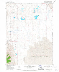
1960s Maps of Box Elder County, Utah
Explore 77 historic maps of Box Elder County from the 1960s. These maps offer a rare glimpse into what life looked like during the 1960s — showing old roads, neighborhoods, homes, and landmarks that have changed or disappeared over time.
Whether you're researching your family's past, planning a metal detecting trip, or studying how Box Elder County's landscape evolved across the 1960s, these high-resolution maps are a powerful tool for exploring the history of this region.
- Focus on a specific era: All maps on this page are from the 1960s, giving you a focused view of this time period.
- See what’s changed: Compare century-old streets, trails, and buildings to today's modern landscape using overlays and satellite layers.
- Research with precision: Use these maps for genealogy, historical research, land use analysis, or educational projects.
- View, download, or print: Maps are fully viewable online in high resolution, and can be downloaded or printed for your own records.
Start exploring Box Elder County's history through authentic maps from the 1960s. This is your window into the past.
Box Elder County, UT maps
(77)- 1960 Map of Ogden
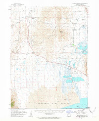
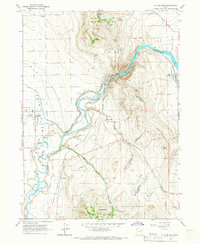
 1960 Ogden1960 Print · USGSIn the mid-1950s, this region of the American West balanced military expansion with frontier history along the Union Pacific RR. Genealogists and historians can trace old settlements like Fort Bridger, the residential growth of Washington Terrace, and industrial sites from the Hill AFB complex to the coal mines of Kemmerer.
 - 1961 Map of Wells
 1961 Wells1961 Print · USGSNortheastern Nevada's high basin and range country is captured here during the early sixties, showing the vital rail corridors and ranching outposts. Researchers can trace the heritage of remote settlements like Metropolis, locate the Delano Mines, and follow the path of the Southern Pacific through the Pequop Mountains.
 - 1961 Map of Thatcher Mountain, 1963 Print
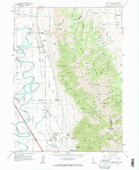
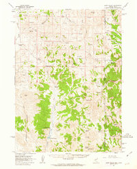
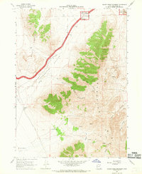
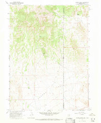
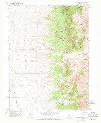
 1961 Thatcher Mountain1963 Print · USGSBox Elder County at the start of the 1960s shows a landscape defined by the vast Bear River Migratory Bird Refuge and local industry. Trace family roots at Penrose Cemetery or explore the rail sidings at Thatcher Siding and Lampo Junction.2 unique versions available
 - 1961 Map of Honeyville, 1963 Print
 1961 Honeyville1963 Print · USGSThe Bear River valley at the foot of the Wellsville Mountains is captured here in the early sixties. Researchers can trace the Union Pacific line through Honeyville and Deweyville, or locate family landmarks like Jensen Spring and Tolman Springs.2 unique versions available
 - 1961 Map of Tremonton, 1963 Print
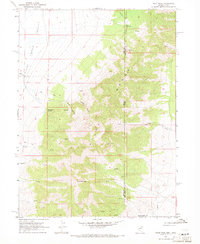
 1961 Tremonton1963 Print · USGSBox Elder County at the start of the 1960s shows a thriving agricultural corridor defined by the Malad River and Bear River. Researchers can trace old property lines and community centers like Tremonton, Riverview Cem, and the Drive-in Theater.
 - 1961 Map of Goose Creek, 1963 Print
 1961 Goose Creek1963 Print · USGSThe tri-state border region of Nevada, Utah, and Idaho comes alive in this early 1960s survey of the High Desert. Historians and genealogists can trace the Old Emigrant Trail and locate family-run outposts like Trout Creek Ranch and Judd Ranch.3 unique versions available
 - 1961 Map of Dairy Valley, 1963 Print
 1961 Dairy Valley1963 Print · USGSRanching and remote mountain routes define this Nevada-Utah borderland in the early sixties. Researchers can trace historic paths through Signboard Pass and locate early settlements like Dairy and Toms Cabin tucked near the high desert springs.2 unique versions available
 - 1962 Map of Elko
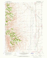
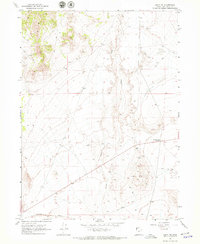
 1962 Elko1962 Print · USGSNortheastern Nevada in the early sixties is a landscape of mountain ranges and rail corridors, where the river valleys support ranching and transit. Locate old mining operations like Battle Creek Mine, rural stops like Moleen, and the sprawling Wendover Bombing and Gunnery Range.
 - 1962 Map of Brigham City
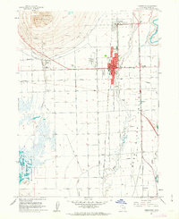
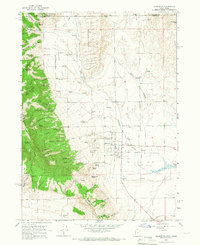
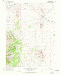
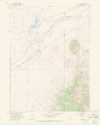
 1962 Brigham City1962 Print · USGSNorthern Utah in the early sixties reveals a landscape of vast salt flats and growing towns along the Wasatch Front. Researchers can trace the Southern Pacific line past the Golden Spike Monument or locate landmarks like Indian Cave and Donner-Reed Pass.
 - 1964 Map of Riverside, 1966 Print
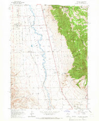
 1964 Riverside1966 Print · USGSBox Elder County at the mid-century shows a landscape shaped by water and rail. Trace the irrigation routes of the Corinne Canal and locate family landmarks like Belmont Church, Garland Cemetery, and the Union Pacific rail siding at Fielding Siding.
 - 1964 Map of Clarkston, 1966 Print
 1964 Clarkston1966 Print · USGSSettled at the foot of the western mountains in the 1960s, this area around Clarkston shows a transition from high forest to fertile valley floor. Genealogists and historians can locate the local Cem, the Gravel Pit, and family-named landmarks like Myler Grove and Archibald Hollow.2 unique versions available
 - 1964 Map of Portage, 1966 Print
 1964 Portage1966 Print · USGSThe Idaho-Utah borderlands are captured here in the mid-1960s, showing the agricultural valley floor set against the peaks of the Cache National Forest. Local researchers can trace family sites in Portage and Washakie, or locate the Washakie Cem and Plymouth Cem.2 unique versions available
 - 1964 Map of Cutler Dam, 1966 Print
 1964 Cutler Dam1966 Print · USGSThe Bear River valley in the mid-1960s shows a landscape of mountain-fringed agriculture and river engineering. Trace the historic rail and water networks connecting Fielding, Cache Junction, and the infrastructure of the Cutler Dam.
 - 1965 Map of Elko
 1965 Elko1965 Print · USGSElko and the northeastern Nevada desert are captured here in the mid-1960s, showcasing a landscape of high ranges and essential rail corridors. Researchers can trace the path of the Western Pacific railroad through small stops like Tobar and Ventosa, or locate remote sites like Shanty Town near the Ruby Lake wetlands.
 - 1966 Map of Thatcher Mountain SW, 1967 Print
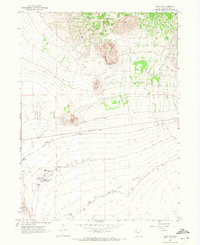
 1966 Thatcher Mountain SW1967 Print · USGSNorthern Utah's salt flats and mountain slopes are captured in the mid-sixties, showcasing the edge of the Bear River Migratory Bird Refuge. Trace the Old Railroad Grade and remote canyons like Davis Canyon or Big Canyon in the Promontory Mountains.
 - 1967 Map of Golden Spike Monument, 1969 Print
 1967 Golden Spike Monument1969 Print · USGSRailroad history dominates this Utah landscape in the late sixties, where the historic meeting of the rails is preserved. Researchers can trace the parallel routes of the Old Central Pacific Grade and Old Union Pacific Grade near the Golden Spike Monument.
 - 1967 Map of East Promontory, 1970 Print
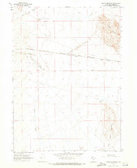
 1967 East Promontory1970 Print · USGSThe eastern slopes of the Promontory Mountains meet the Great Salt Lake wetlands in the late sixties. Genealogists and historians can trace water rights and land use through landmarks like Sweetwater Spring, East Promontory, and the Gravel Pit.2 unique versions available
 - 1967 Map of Jackson Spring, 1971 Print
 1967 Jackson Spring1971 Print · USGSCrossing the Nevada-Utah border in the late sixties, this survey captures a high-desert landscape of mining and remote spring sites. Researchers can locate Jackson Mines and trace essential water sources like Kilgore Spring and Jackson Spring along the primitive jeep trails.2 unique versions available
 - 1967 Map of Pilot Peak, 1971 Print
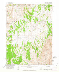
 1967 Pilot Peak1971 Print · USGSThe high desert of Elko County and the Nevada-Utah border are captured here in the late 1960s. Researchers can trace the remote ranching life at Bar O Ranch or map the water sources and drainage patterns through Horse Canyon and Bettridge Creek.2 unique versions available
 - 1967 Map of Pigeon Mountain, 1971 Print
 1967 Pigeon Mountain1971 Print · USGSThe Great Salt Lake Desert in the late sixties reveals a landscape shaped by rail engineering and mineral extraction. Trace the famous Southern Pacific (Lucin Cutoff) and explore remnants of earlier routes like the Old RR Grade and the Lucin Airfield.2 unique versions available
 - 1967 Map of Lucin, 1971 Print
 1967 Lucin1971 Print · USGSRailroad and pioneer history converge in this western Utah desert during the late sixties. Trace the legendary Emigrant Trail as it crosses the Southern Pacific tracks near the isolated settlement of Lucin and its historic Cem.2 unique versions available
 - 1967 Map of Patterson Pass, 1971 Print
 1967 Patterson Pass1971 Print · USGSThe Nevada-Utah borderlands are captured here in the late sixties, where the high desert flats meet the steep slopes of the Pilot Range. Researchers can trace the mid-century mining landscape through sites like Copper Mtn, several scattered Mines, and water features including Parson Springs and a prominent AQUEDUCT.2 unique versions available
 - 1967 Map of Lucin NW, 1971 Print
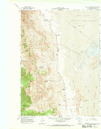
 1967 Lucin NW1971 Print · USGSBox Elder County ranching and mining lands are captured in the late sixties as the high desert landscape transitioned between old trails and modern transit. Trace the Old Emigrant (Jeep) Trail or locate isolated mining Prospects near Grouse Creek.3 unique versions available
 - 1967 Map of Tecoma, 1971 Print
 1967 Tecoma1971 Print · USGSCrossing the Nevada-Utah state line in the late sixties, this survey captures the high-basin rail corridor and the foothills of the Pilot Range. Genealogists and researchers can locate Tuttle and Buell, along with the Pearson Ranch and Copper Mtn Mines.2 unique versions available
 - 1967 Map of Lucin NE, 1971 Print
 1967 Lucin NE1971 Print · USGSBox Elder County at the end of the sixties shows a landscape defined by historic transit and vital desert water sources. Trace the path of the Old Emigrant Trail and the Central Pacific Old Grade or locate remote springs like Owl Spring.3 unique versions available
Showing maps 1-25 of 77
Top cities of Box Elder County
- Brigham City historical maps
- Tremonton historical maps
- Perry historical maps
- Garland historical maps
- Willard historical maps
- Honeyville historical maps
See more
Frequently asked questions
- What are the different types of historical maps available for Box Elder County?
- What is the oldest map of Box Elder County?
- Where can I purchase historical maps of Box Elder County for my home or office?
- Where can I download high-res historical maps of Box Elder County?
- Are there historical topographic maps available for Box Elder County?
- Is there historical aerial imagery available for Box Elder County?
- Where are historical maps of Box Elder County sourced from?