1950s Maps of Carbon County, Utah
Explore 8 historic maps of Carbon County from the 1950s. These maps offer a rare glimpse into what life looked like during the 1950s — showing old roads, neighborhoods, homes, and landmarks that have changed or disappeared over time.
Whether you're researching your family's past, planning a metal detecting trip, or studying how Carbon County's landscape evolved across the 1950s, these high-resolution maps are a powerful tool for exploring the history of this region.
- Focus on a specific era: All maps on this page are from the 1950s, giving you a focused view of this time period.
- See what’s changed: Compare century-old streets, trails, and buildings to today's modern landscape using overlays and satellite layers.
- Research with precision: Use these maps for genealogy, historical research, land use analysis, or educational projects.
- View, download, or print: Maps are fully viewable online in high resolution, and can be downloaded or printed for your own records.
Start exploring Carbon County's history through authentic maps from the 1950s. This is your window into the past.
Carbon County, UT maps
(8)- 1950 Map of Woodside
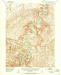
 1950 Woodside1950 Print · USGSEmery County was a landscape of deep canyons and rail-side outposts at the midpoint of the twentieth century. Researchers can trace the industrial footprint of the Geneva Coal Mine or locate early settlements and family landmarks like Woodside, Silvagni Ranch, and the local Cem.2 unique versions available
 - 1953 Map of Nutters Hole, 1954 Print
 1953 Nutters Hole1954 Print · USGSThe Green River backcountry of eastern Utah is shown here in the early 1950s before modern infrastructure changed the reach of the basin. Genealogists and historians can locate the Sand Wash Ferry (Site) and trace the boundaries of the Uintah and Ouray Indian Reservation.3 unique versions available
 - 1953 Map of Firewater Canyon, 1955 Print
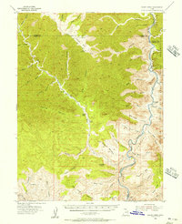
 1953 Firewater Canyon1955 Print · USGSThe Green River flows through the remote canyons of Uintah County in the early 1950s, documenting a time of isolation in the Uintah and Ouray Indian Reservation. Researchers can trace old routes and water sources like Tabyago Spring, School Section Canyon, and Rock House Bottom.3 unique versions available
 - 1954 Map of Flat Canyon, 1956 Print
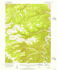 1954 Flat Canyon1956 Print · USGSThe high plateau country of Carbon and Uintah counties is documented here in the mid-fifties, dominated by the winding course of the Green River. Researchers can trace the remote Rock Creek Ranch and locate early energy infrastructure like the isolated Gas Well on Cedar Ridge.2 unique versions available
 - 1954 Map of Range Creek, 1956 Print
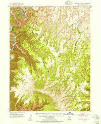
 1954 Range Creek1956 Print · USGSEastern Utah in the mid-fifties remains a world of remote cattle outposts and deep river gorges. Researchers can trace the isolated Pilling Ranch and Wilcox Ranch along Range Creek, or follow the winding Green River through the heart of Desolation Canyon.3 unique versions available
 - 1956 Map of Price, 1968 Print
 1956 Price1968 Print · USGSCentral Utah in the mid-fifties showcases a landscape shaped by coal mining and mountain-fed irrigation. Trace the rail-and-river economy through the Geneva Coal Mine, the Union Pacific line, and settlements like Price and Ephraim.3 unique versions available
 - 1956 Map of Grand Junction, 1973 Print
 1956 Grand Junction1973 Print · USGSThe Grand Valley and its surrounding high plateaus are captured here in the mid-twentieth century as the region's ranching and rail heritage remained central. Researchers can trace the path of the Denver & Rio Grande Western RR through Grand Junction or locate remote outposts like Dragon and Atchee.2 unique versions available
 - 1959 Map of Grand Junction
 1959 Grand Junction1959 Print · USGSThe Grand Valley and the high plateaus of the Colorado-Utah border come into focus in the late fifties as irrigation and rail lines define the landscape. Local historians can trace several industrial outposts labeled as abandoned, including Watson and Dragon, alongside the Denver and Rio Grande Western RR.
End of results
Showing maps 1-8 of 8
Top cities of Carbon County
Frequently asked questions
- What are the different types of historical maps available for Carbon County?
- What is the oldest map of Carbon County?
- Where can I purchase historical maps of Carbon County for my home or office?
- Where can I download high-res historical maps of Carbon County?
- Are there historical topographic maps available for Carbon County?
- Is there historical aerial imagery available for Carbon County?
- Where are historical maps of Carbon County sourced from?