1990s Maps of Kane County, Utah
Explore 9 historic maps of Kane County from the 1990s. These maps offer a rare glimpse into what life looked like during the 1990s — showing old roads, neighborhoods, homes, and landmarks that have changed or disappeared over time.
Whether you're researching your family's past, planning a metal detecting trip, or studying how Kane County's landscape evolved across the 1990s, these high-resolution maps are a powerful tool for exploring the history of this region.
- Focus on a specific era: All maps on this page are from the 1990s, giving you a focused view of this time period.
- See what’s changed: Compare century-old streets, trails, and buildings to today's modern landscape using overlays and satellite layers.
- Research with precision: Use these maps for genealogy, historical research, land use analysis, or educational projects.
- View, download, or print: Maps are fully viewable online in high resolution, and can be downloaded or printed for your own records.
Start exploring Kane County's history through authentic maps from the 1990s. This is your window into the past.
Kane County, UT maps
(9)- 1997 Map of Springdale East, 2002 Print
 1997 Springdale East2002 Print · USGSThe canyon country of southern Utah is shown here in the late nineties as tourism and preservation defined the land. Genealogists can locate Shunesburg and the Cem near the river, while hikers trace the Zion-Mount Carmel Tunnel and Checkerboard Mesa.
 - 1997 Map of Egypt, 2002 Print
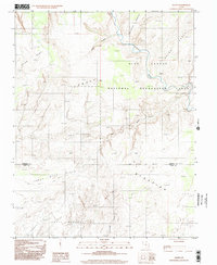 1997 Egypt2002 Print · USGSGarfield and Kane counties meet in this late-twentieth-century study of the high desert canyonlands. Local historians and explorers can trace the complex drainages of Twentyfive Mile Wash and the Escalante River near landmarks like Egypt.
 - 1997 Map of King Mesa, 2002 Print
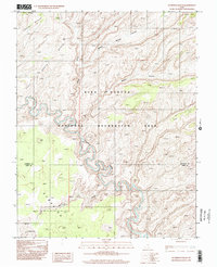
 1997 King Mesa2002 Print · USGSThe Kane County desert is documented here in the late nineties, showcasing the complex canyons of the Glen Canyon National Recreation Area. Researchers can trace remote desert routes and find natural landmarks like Jacob Hamblin Arch, Coyote Natural Bridge, and the Escalante River.
 - 1997 Map of Sunset Flat, 2002 Print
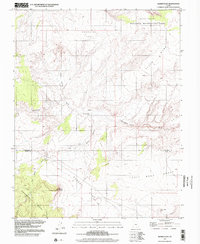 1997 Sunset Flat2002 Print · USGSHigh desert benches and seasonal washes define this Garfield County landscape in the late 1990s. Local researchers can trace old livestock routes and water sources including Twentyfive-Mile Corral, Little Red Rock Spring, and White Point.
 - 1997 Map of Temple of Sinawava, 2002 Print
 1997 Temple of Sinawava2002 Print · USGSZion National Park at the close of the century reveals the intricate canyon geography of the North Fork Virgin River. Trace the steep paths of the West Rim Trail (Pack) and East Rim Trail (Pack) past landmarks like Angels Landing and The Pulpit.
 - 1997 Map of Stevens Canyon South, 2002 Print
 1997 Stevens Canyon South2002 Print · USGSThe Escalante River and its deep canyon tributaries are captured here in the late nineties as they meet the rising waters. Researchers can trace the shoreline of Lake Powell and locate landmarks like Stevens Natural Arch and Fortymile Ridge.
 - 1997 Map of Stevens Canyon North, 2002 Print
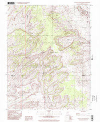 1997 Stevens Canyon North2002 Print · USGSSouthern Utah’s high desert landscape is documented here during the late twentieth century, capturing the complex geology of the Waterpocket Fold. Researchers can trace the rugged drainages of Stevens Canyon and Halls Creek through the Capitol Reef National Park wilderness.
 - 1997 Map of Rainbow Bridge, 2002 Print
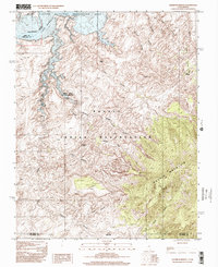 1997 Rainbow Bridge2002 Print · USGSThe Utah-Arizona borderlands at the end of the twentieth century reveal a terrain defined by ancient geological wonders and the rising waters of Lake Powell. Researchers can trace the path to Rainbow Bridge and the high slopes of Navajo Mountain within the Navajo Indian Reservation.
 - 1997 Map of Scorpion Gulch, 2002 Print
 1997 Scorpion Gulch2002 Print · USGSThe canyonlands of southern Utah are captured in the late twentieth century, showing a landscape defined by the winding Escalante River. Researchers can trace the rugged drainage of Scorpion Gulch and the expansive vistas of Baker Bench.
End of results
Showing maps 1-9 of 9
Top cities of Kane County
- Kanab historical maps
- Orderville historical maps
- Big Water historical maps
- Glendale historical maps
- Alton historical maps
Frequently asked questions
- What are the different types of historical maps available for Kane County?
- What is the oldest map of Kane County?
- Where can I purchase historical maps of Kane County for my home or office?
- Where can I download high-res historical maps of Kane County?
- Are there historical topographic maps available for Kane County?
- Is there historical aerial imagery available for Kane County?
- Where are historical maps of Kane County sourced from?