1950s Maps of Kane County, Utah
Explore 39 historic maps of Kane County from the 1950s. These maps offer a rare glimpse into what life looked like during the 1950s — showing old roads, neighborhoods, homes, and landmarks that have changed or disappeared over time.
Whether you're researching your family's past, planning a metal detecting trip, or studying how Kane County's landscape evolved across the 1950s, these high-resolution maps are a powerful tool for exploring the history of this region.
- Focus on a specific era: All maps on this page are from the 1950s, giving you a focused view of this time period.
- See what’s changed: Compare century-old streets, trails, and buildings to today's modern landscape using overlays and satellite layers.
- Research with precision: Use these maps for genealogy, historical research, land use analysis, or educational projects.
- View, download, or print: Maps are fully viewable online in high resolution, and can be downloaded or printed for your own records.
Start exploring Kane County's history through authentic maps from the 1950s. This is your window into the past.
Kane County, UT maps
(39)- 1953 Map of Mt Pennell 3 SW, 1954 Print
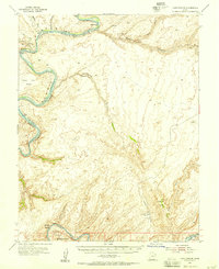
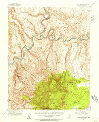
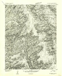 1953 Mt Pennell 3 SW1954 Print · USGSSouthern Utah’s high plateau country is captured in the early 1950s as a complex network of canyons and drainage basins. Researchers can trace the winding course of East Moody Canyon and locate geographic markers such as Miller Creek and the high point at VABM 6748.
 - 1953 Map of Circle Cliffs 4 SW, 1954 Print
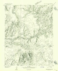 1953 Circle Cliffs 4 SW1954 Print · USGSSouthern Utah's high desert benches and river corridors are meticulously charted in the mid-1950s as topographic mapping of the Colorado Plateau expanded. Researchers can trace the winding path of the Escalante River and explore named terrain like Scorpion Flat and Baker Bench.
 - 1953 Map of Cummings Mesa, 1955 Print
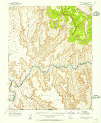 1953 Cummings Mesa1955 Print · USGSGlen Canyon and the Colorado River borderlands appear here in the early fifties, before modern changes to the river's flow. You can trace the remote locations of river bars and canyons such as Klondike Bar, Wild Horse Bar, and the depths of Glen Canyon.3 unique versions available
 - 1953 Map of The Rincon, 1956 Print
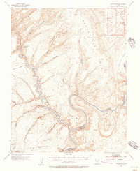 1953 The Rincon1956 Print · USGSSouthern Utah’s high desert is captured in the early fifties, just as the canyon country was being systematically mapped for its geology and navigation. Researchers can locate remote landmarks like the Hole in the Rock Historical Marker and the iconic Gregory Natural Bridge.3 unique versions available
 - 1953 Map of Lake Canyon, 1956 Print
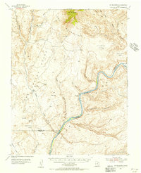
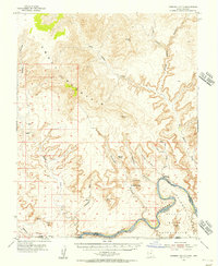
 1953 Lake Canyon1956 Print · USGSSoutheastern Utah remains an intricate labyrinth of deep canyons and river bends during the early fifties. Researchers can trace the original paths of the Colorado River and San Juan River, identifying Cliff Dwellings, the historic Hall Trail, and various named river bars.3 unique versions available
 - 1953 Map of Mt. Ellsworth, 1956 Print
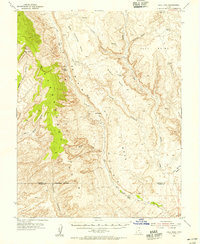
 1953 Mt. Ellsworth1956 Print · USGSThe Colorado River corridor near the Henry Mountains appears here in the mid-1950s, shortly before the flooding of the canyon floor. Researchers can trace the original river course past Good Hope Bar, Olympia Bar, and the rugged Hoskinnini Mesa.4 unique versions available
 - 1953 Map of Hall Mesa, 1956 Print
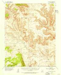
 1953 Hall Mesa1956 Print · USGSGarfield County's high desert was a landscape of remote ranching and early resource exploration in the 1950s. You can trace the rugged descent of the Waterpocket Fold and locate isolated landmarks like the Baker Ranch and a remote Landing Strip.4 unique versions available
 - 1953 Map of Nipple Butte, 1956 Print
 1953 Nipple Butte1956 Print · USGSThe high plateaus of the Utah-Arizona border are shown here in the early fifties, before the landscape was altered by massive downstream damming. Researchers can trace remote water sources and cattle-country landmarks like Jacobs Tanks, Alkali Seep, and the Windmill below Nipple Butte.2 unique versions available
 - 1953 Map of Navajo Mountain, 1956 Print
 1953 Navajo Mountain1956 Print · USGSThe high desert and river canyons of the Utah-Arizona border are shown here in the early 1950s, before the landscape was altered by major dams. Researchers can trace remote trails leading to Rainbow Bridge National Monument, the Navajo Mountain Sch, and War God Spring.3 unique versions available
 - 1953 Map of Gunsight Butte, 1956 Print
 1953 Gunsight Butte1956 Print · USGSGlen Canyon and the Colorado River appear here in the early fifties, before the landscape was transformed by the rising waters of Lake Powell. Researchers can trace the original riverbed past the Crossing of the Fathers and identify landmarks like Gunsight Butte and Alstrom Point.3 unique versions available
 - 1953 Map of Moody Creek, 1957 Print
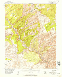 1953 Moody Creek1957 Print · USGSGarfield and Kane Counties are shown in the early fifties as a labyrinth of high sandstone plateaus and deep river canyons. Researchers can trace remote mining activity at the Hotshot Prospect or locate a mid-century Landing Strip deep within the Circle Cliffs.4 unique versions available
 - 1953 Map of Cedar City, 1966 Print
 1953 Cedar City1966 Print · USGSSouthwestern Utah's high plateaus and desert basins are mapped here during the mid-fifties, showing the region before the modern interstate system. Researchers can trace historic mining at Silver Reef, follow the Union Pacific line, and locate early settlements like Kanarraville and Toquerville.3 unique versions available
 - 1954 Map of Buckskin Gulch NW
 1954 Buckskin Gulch NW1954 Print · USGSKane County ranching life in the mid-fifties centered on isolated outposts in a landscape of deep canyons and high points. Researchers can trace historic land use at Nephi Ranch and Clark Ranch or locate water sources like Wildcat Spring.
 - 1954 Map of Buckskin Gulch NE
 1954 Buckskin Gulch NE1954 Print · USGSKane County in the mid-1950s was a landscape defined by cattle ranching and deep desert canyons. Researchers can trace historic routes like Paria Road and locate remote water sources such as Kitchen Corral Spring and Water Holes.
 - 1954 Map of Buckskin Gulch SE
 1954 Buckskin Gulch SE1954 Print · USGSThe high desert borderlands between Utah and Arizona are mapped here in the mid-1950s, showcasing a landscape of deep canyons and isolated ranching outposts. Researchers can trace the rugged cattle country surrounding Jepson Ranch and follow old routes through Buckskin Gulch and Wire Pass.
 - 1954 Map of Buckskin Gulch SW
 1954 Buckskin Gulch SW1954 Print · USGSRanching life on the Utah-Arizona border during the mid-fifties centered on isolated homesteads and dependable water sources. Researchers can trace the layout of Hoda Ranch and School Section Ranch or follow the Old Arizona Road across the desert.
 - 1954 Map of Johnson SE, 1956 Print
 1954 Johnson SE1956 Print · USGSThe high desert of the Utah-Arizona border comes into focus in the mid-1950s, showing a land of deep canyons and seasonal washes. Trace the early road network from Johnson (Site) past Cliff Dwellings and essential water sources like Navajo Well.
 - 1954 Map of Kanab SW, 1956 Print
 1954 Kanab SW1956 Print · USGSThe Utah-Arizona borderlands in the mid-1950s reveal a landscape of isolated springs and deep drainages. Researchers can trace the rugged terrain of Yellowjacket Canyon and locate remote water sources like Sand Spring and Harris Springs.
 - 1954 Map of Orderville Canyon NW, 1956 Print
 1954 Orderville Canyon NW1956 Print · USGSThe high plateau country along the Iron and Washington County line is captured here in the early fifties. Researchers can trace the ranching history of the area via features like Virgin Flats and various Stock Tank sites near Miners Peak.
 - 1954 Map of Orderville Canyon SE, 1956 Print
 1954 Orderville Canyon SE1956 Print · USGSKane County ranching and river drainage are documented in the mid-1950s before significant modern development altered these remote canyon lands. Researchers can trace land use through Winders Ranch, the North Fork Virgin River, and Jolly Gulch.
 - 1954 Map of Johnson NE, 1956 Print
 1954 Johnson NE1956 Print · USGSKane County's high desert plateaus are captured here in the mid-fifties, showing a landscape defined by deep erosion and isolated mining. Researchers can trace early resource extraction at the Montezuma Mine or locate water sources like Neaf Spring and the White Cliffs.
 - 1954 Map of Paria NW, 1956 Print
 1954 Paria NW1956 Print · USGSThe high desert of Kane County is captured in the mid-fifties, dominated by the striking geologic uplift of The Cockscomb. Genealogists and historians can locate a remote Cemetery and trace the original water routes of the Paria River and Cottonwood Creek.
 - 1954 Map of Kanab SE, 1956 Print
 1954 Kanab SE1956 Print · USGSThe Utah-Arizona borderlands come into focus during the mid-fifties, centered on the settlement of Kanab and the northern edge of the Kaibab Indian Reservation. Researchers can locate a Cem, the local Landing Strip, and ancient Cliff Dwellings tucked into the surrounding canyons.
 - 1954 Map of Paria SW, 1956 Print
 1954 Paria SW1956 Print · USGSThe Utah-Arizona borderlands appear as a rugged frontier in the mid-1950s, defined by the winding Paria River. Researchers can trace the remnants of early settlement at Adairville or locate landmarks like the Johnson Store and Steamboat Rock.
 - 1954 Map of Johnson SW, 1956 Print
 1954 Johnson SW1956 Print · USGSSouthern Utah and northern Arizona were documented in this 1950s survey during an era of significant topographic mapping across the Vermilion Cliffs. Researchers can trace old ranching activity at Robinson Ranch and locate remote water sources such as Sheep Spring and Hog Canyon Spring.
Showing maps 1-25 of 39
Top cities of Kane County
- Kanab historical maps
- Orderville historical maps
- Big Water historical maps
- Glendale historical maps
- Alton historical maps
Frequently asked questions
- What are the different types of historical maps available for Kane County?
- What is the oldest map of Kane County?
- Where can I purchase historical maps of Kane County for my home or office?
- Where can I download high-res historical maps of Kane County?
- Are there historical topographic maps available for Kane County?
- Is there historical aerial imagery available for Kane County?
- Where are historical maps of Kane County sourced from?