1970s Maps of Rich County, Utah
Explore 4 historic maps of Rich County from the 1970s. These maps offer a rare glimpse into what life looked like during the 1970s — showing old roads, neighborhoods, homes, and landmarks that have changed or disappeared over time.
Whether you're researching your family's past, planning a metal detecting trip, or studying how Rich County's landscape evolved across the 1970s, these high-resolution maps are a powerful tool for exploring the history of this region.
- Focus on a specific era: All maps on this page are from the 1970s, giving you a focused view of this time period.
- See what’s changed: Compare century-old streets, trails, and buildings to today's modern landscape using overlays and satellite layers.
- Research with precision: Use these maps for genealogy, historical research, land use analysis, or educational projects.
- View, download, or print: Maps are fully viewable online in high resolution, and can be downloaded or printed for your own records.
Start exploring Rich County's history through authentic maps from the 1970s. This is your window into the past.
Rich County, UT maps
(4)- 1970 Map of Bear Lake North, 1973 Print
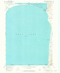 1970 Bear Lake North1973 Print · USGSThe northern reaches of the Idaho-Utah border come alive in the 1970s, centered on the diverse shorelines of Bear Lake. Trace the development of North Beach State Park and locate historic sites like Bear Lake Hot Springs and the settlement of Lifton.
 - 1970 Map of Boundary Ridge, 1973 Print
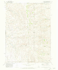 1970 Boundary Ridge1973 Print · USGSBoundary Ridge stood at the remote intersection of three states in the early seventies, a landscape of high plateaus and vital mountain springs. Researchers can trace historic grazing routes through Taylor Meadow and locate landmarks like the Windmill or the heights of Red Mtn.
 - 1970 Map of Pegram Creek, 1973 Print
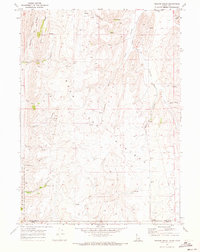 1970 Pegram Creek1973 Print · USGSThe high Idaho-Utah borderlands come into focus in the early seventies, detailing the isolated terrain of the Bear Lake Plateau. Researchers can trace old resource tracks and infrastructure including jeep trails, a prominent pipeline, and a remote quarry.2 unique versions available
 - 1977 Map of Bear Lake North, 1980 Print
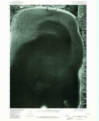 1977 Bear Lake North1980 Print · USGSThe northern shores of the Idaho-Utah border appear in sharp detail during the late seventies, showing the landscape just as modern recreational use was evolving. Researchers can trace the shoreline geography near Lifton, the marshy borders of Mud Lake, and the prominent Bear Lake Sands.
End of results
Showing maps 1-4 of 4
Top cities of Rich County
Frequently asked questions
- What are the different types of historical maps available for Rich County?
- What is the oldest map of Rich County?
- Where can I purchase historical maps of Rich County for my home or office?
- Where can I download high-res historical maps of Rich County?
- Are there historical topographic maps available for Rich County?
- Is there historical aerial imagery available for Rich County?
- Where are historical maps of Rich County sourced from?