1900s (20th Century) Maps of Monroe, Utah
Explore 9 historic maps of Monroe from the 1900s (20th Century). These maps offer a rare glimpse into what life looked like during the 1900s — showing old roads, neighborhoods, homes, and landmarks that have changed or disappeared over time.
Whether you're researching your family's past, planning a metal detecting trip, or studying how Monroe's landscape evolved across the 1900s, these high-resolution maps are a powerful tool for exploring the history of this region.
- Focus on a specific era: All maps on this page are from the 1900s, giving you a focused view of this time period.
- See what’s changed: Compare century-old streets, trails, and buildings to today's modern landscape using overlays and satellite layers.
- Research with precision: Use these maps for genealogy, historical research, land use analysis, or educational projects.
- View, download, or print: Maps are fully viewable online in high resolution, and can be downloaded or printed for your own records.
Start exploring Monroe's history through authentic maps from the 1900s. This is your window into the past.
Monroe, UT maps
(9)- 1940 Map of Monroe, 1957 Print
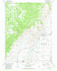
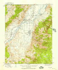 1940 Monroe1957 Print · USGSThe Sevier River valley was a thriving corridor of rail and irrigation just before the mid-century. Researchers can trace the path of the Denver and Rio Grande Western Railroad through Monroe or locate the Antelope Mine and Poverty Flat Ranch.2 unique versions available
 - 1944 Map of Monroe
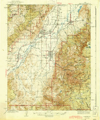 1944 Monroe1944 Print · USGSThe Sevier River Valley thrived as a hub of irrigation and rail transport in the mid-twentieth century. Genealogists and historians can trace the foundations of Monroe, Elsinore, and Annabella alongside the ANTELOPE MINE and Poverty Flat Ranch.
 - 1953 Map of Richfield, 1963 Print
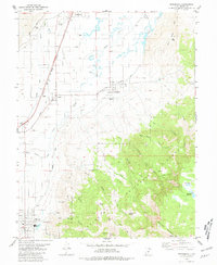
 1953 Richfield1963 Print · USGSCentral Utah in the early fifties reveals a complex geography of high plateaus and desert basins tied together by the Union Pacific rail lines. Genealogists and historians can trace family roots in Richfield or Kanosh and locate remote operations like the Blue Star Mine or Newhouse.3 unique versions available
 - 1958 Map of Richfield
 1958 Richfield1958 Print · USGSCentral Utah in the late fifties shows a landscape of mountain forests and desert basins connected by the Union Pacific Railroad. Genealogists and historians can trace rail stops at Nada Station, mines like the Blue Star Mine, and tribal lands of the Paiute Indian Reservation.2 unique versions available
 - 1980 Map of Antelope Range, 1981 Print
 1980 Antelope Range1981 Print · USGSThe Sevier River valley in the early 1980s shows a landscape of rail-fed settlements and mountain mining. Trace family roots in Joseph and Sevier, or locate historic workings like the Antelope Mine and the irrigation network of Bertlesen Ditch.2 unique versions available
 - 1980 Map of Monroe Peak, 1981 Print
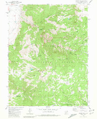 1980 Monroe Peak1981 Print · USGSThe high country of the Sevier-Piute border is captured here in the early 1980s, where high-altitude meadows meet essential irrigation infrastructure. Researchers can trace remote mountain trails and land use around Monroe Peak, Monrovian Park Campground, and Monroe Meadows.2 unique versions available
 - 1980 Map of Elsinore, 1981 Print
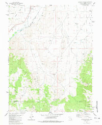
 1980 Elsinore1981 Print · USGSThe Sevier River valley thrives as an irrigated agricultural corridor in the early 1980s, where rail and water define the landscape. Local historians can trace the paths of the Denver and Rio Grande Western through Elsinore and Joseph, or locate rural landmarks like the Rodeo Ground and regional Cemeteriers.
 - 1980 Map of Annabella, 1981 Print
 1980 Annabella1981 Print · USGSThe Sevier River valley in the early eighties shows a landscape shaped by irrigation and the railroad. Genealogists and historians can trace the communities of Annabella, Central, and Austin, or locate landmarks like South Sevier High Sch and the Municipal Airport.
 - 1980 Map of Richfield, 1987 Print
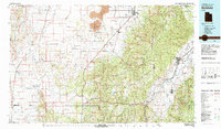 1980 Richfield1987 Print · USGSCentral Utah in the early eighties shows a landscape of volcanic fields and high mountain forests. Genealogists can trace family roots through the Sevier River valley in Richfield, Fillmore, and Monroe, or follow the Union Pacific rail lines.2 unique versions available
End of results
Showing maps 1-9 of 9
Top cities near Monroe
- Richfield historical maps
- Elsinore historical maps
- Annabella historical maps
- Glenwood historical maps
- Sigurd historical maps
- Central Valley historical maps
See more
Frequently asked questions
- What are the different types of historical maps available for Monroe?
- What is the oldest map of Monroe?
- Where can I purchase historical maps of Monroe for my home or office?
- Where can I download high-res historical maps of Monroe?
- Are there historical topographic maps available for Monroe?
- Is there historical aerial imagery available for Monroe?
- Where are historical maps of Monroe sourced from?