1940s Maps of Fairfield, Utah
Explore 4 historic maps of Fairfield from the 1940s. These maps offer a rare glimpse into what life looked like during the 1940s — showing old roads, neighborhoods, homes, and landmarks that have changed or disappeared over time.
Whether you're researching your family's past, planning a metal detecting trip, or studying how Fairfield's landscape evolved across the 1940s, these high-resolution maps are a powerful tool for exploring the history of this region.
- Focus on a specific era: All maps on this page are from the 1940s, giving you a focused view of this time period.
- See what’s changed: Compare century-old streets, trails, and buildings to today's modern landscape using overlays and satellite layers.
- Research with precision: Use these maps for genealogy, historical research, land use analysis, or educational projects.
- View, download, or print: Maps are fully viewable online in high resolution, and can be downloaded or printed for your own records.
Start exploring Fairfield's history through authentic maps from the 1940s. This is your window into the past.
Fairfield, UT maps
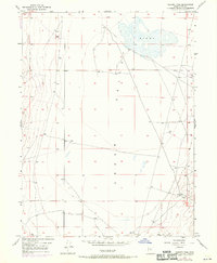
(4)- 1947 Map of Fivemile Pass, 1953 Print
 1947 Fivemile Pass1953 Print · USGSUtah's high desert reveals its mining and transit legacy in the late 1940s as the East Tintic Mountains hum with mineral extraction. Trace the storied Pony Express Route or locate historic operations like the Lehi Tintic Mine and the settlement of Topliff.
 - 1947 Map of Goshen Pass, 1970 Print
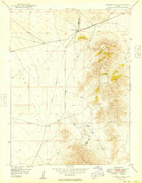
 1947 Goshen Pass1970 Print · USGSCedar Valley remains a stark and open landscape in the late 1940s, defined by its vital water sources and mountain corridors. Researchers can trace the early infrastructure of this arid basin through sites like the Sinks, several remote Well points, and the narrow transit at Goshen Pass.2 unique versions available
 - 1949 Map of Fivemile Pass
 1949 Fivemile Pass1949 Print · USGSTooele and Utah County lines intersect here in the late 1940s, revealing a landscape shaped by strategic desert passes and shifting rail lines. Trace the industrial footprint of the (Dismantled Railroad) leading to Topliff or follow the Union Pacific through Fivemile Pass.2 unique versions available
 - 1949 Map of Goshen Pass
 1949 Goshen Pass1949 Print · USGSCedar Valley at the end of the 1940s reveals a sparsely settled Utah landscape defined by its high-desert hydrology and transit routes. Researchers can trace early roads leading to the Goshen Pass corridor and locate water sources like the Sinks.
End of results
Showing maps 1-4 of 4
Top cities near Fairfield
- Lehi historical maps
- Eagle Mountain historical maps
- Saratoga Springs historical maps
- Herriman historical maps
- Draper historical maps
- Bluffdale historical maps
See more
Frequently asked questions
- What are the different types of historical maps available for Fairfield?
- What is the oldest map of Fairfield?
- Where can I purchase historical maps of Fairfield for my home or office?
- Where can I download high-res historical maps of Fairfield?
- Are there historical topographic maps available for Fairfield?
- Is there historical aerial imagery available for Fairfield?
- Where are historical maps of Fairfield sourced from?