1950s Maps of Wayne County, Utah
Explore 45 historic maps of Wayne County from the 1950s. These maps offer a rare glimpse into what life looked like during the 1950s — showing old roads, neighborhoods, homes, and landmarks that have changed or disappeared over time.
Whether you're researching your family's past, planning a metal detecting trip, or studying how Wayne County's landscape evolved across the 1950s, these high-resolution maps are a powerful tool for exploring the history of this region.
- Focus on a specific era: All maps on this page are from the 1950s, giving you a focused view of this time period.
- See what’s changed: Compare century-old streets, trails, and buildings to today's modern landscape using overlays and satellite layers.
- Research with precision: Use these maps for genealogy, historical research, land use analysis, or educational projects.
- View, download, or print: Maps are fully viewable online in high resolution, and can be downloaded or printed for your own records.
Start exploring Wayne County's history through authentic maps from the 1950s. This is your window into the past.
Wayne County, UT maps
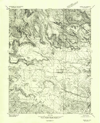
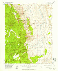
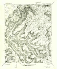
(45)- 1951 Map of Upheaval Dome, 1955 Print
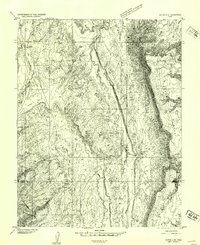
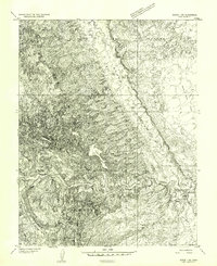
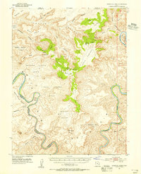 1951 Upheaval Dome1955 Print · USGSThe confluence region of the Green and Colorado Rivers is captured here in the early 1950s, documenting a remote wilderness of canyons and high mesas. Researchers can locate ancient Cliff Dwellings near Aztec Butte or trace the intricate river bends at Turks Head and Goose Neck.3 unique versions available
 - 1952 Map of Notom 2 NW, 1954 Print
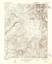
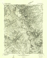
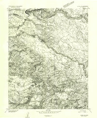
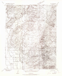
 1952 Notom 2 NW1954 Print · USGSHigh in the Fishlake National Forest during the early fifties, this survey captures the wild plateaus and alpine lakes of Wayne County. Researchers can trace historic access points like Billings Pass or locate the Jackson Ridge Forest Camp and Deep Creek Lake.
 - 1952 Map of Loa 1 SE, 1954 Print
 1952 Loa 1 SE1954 Print · USGSBicknell and the high desert of Rabbit Valley are captured here in the early fifties, showing a landscape defined by irrigation and mountain transit. Genealogists and historians can trace local roots at the Bicknell Cemetery or follow the historic Aquarius Trail into the Dixie National Forest.
 - 1952 Map of Notom 3 NW, 1954 Print
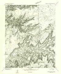
 1952 Notom 3 NW1954 Print · USGSThe high plateau of Wayne County is captured in the early 1950s, documenting a remote landscape of alpine lakes and grazing lands. Researchers can trace historic water sources and stock routes through Donkey Meadows, Blind Lake, and Stink Flats.
 - 1952 Map of Notom 2 SE, 1954 Print
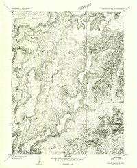
 1952 Notom 2 SE1954 Print · USGSThe canyonlands of Wayne County come alive in this mid-century survey of the Fremont River valley. Researchers can trace the early roads and orchards of Fruita or locate the dramatic geological formations of The Moenkopi and Twin Rocks.
 - 1952 Map of Notom 2 SW, 1954 Print
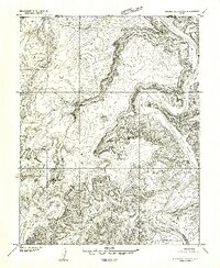
 1952 Notom 2 SW1954 Print · USGSSettlements in Wayne County appear during the early fifties as the region balanced cattle ranching with new infrastructure. Genealogists and historians can locate the Teasdale Cem, the Municipal Airport, and the irrigation network of the Fremont River.
 - 1952 Map of Notom 4 NW, 1954 Print
 1952 Notom 4 NW1954 Print · USGSThe high desert canyons and cattle ranching territory of south-central Utah are documented here in the early fifties. Local historians can trace the bounds of the Dixie National Forest and identify landmarks like Pleasant Creek Ranch, Hanks Tower, and Ferns Nipple.
 - 1952 Map of Carlisle 2 NW, 1954 Print
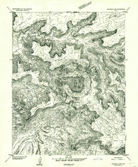 1952 Carlisle 2 NW1954 Print · USGSSoutheast Utah's high plateau and canyon country are captured in the early 1950s, showing the dramatic geologic relief of the Green River corridor. Trace the isolation of the Upheaval Dome and the remote river flats at Valentine Bottom and Upheaval Bottom.
 - 1952 Map of Carlisle 2 SW, 1954 Print
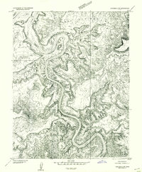 1952 Carlisle 2 SW1954 Print · USGSThe Green River loops through the San Juan and Wayne County borders in the early 1950s, revealing a landscape defined by deep canyons and sheer rock shelves. Researchers can trace the dramatic bends of Stillwater Canyon and locate landmarks like Turks Head and the White Rim.
 - 1952 Map of Notom 4 NE, 1954 Print
 1952 Notom 4 NE1954 Print · USGSSoutheast Utah at the start of the fifties reveals a world of desert outposts and livestock routes along the base of the mesas. Trace the seasonal drainages of Burro Wash and the landmarks at Tenison Flats or the remote Bloody Hands Gap.
 - 1952 Map of Notom 2 NE, 1954 Print
 1952 Notom 2 NE1954 Print · USGSThe high plateau country of Wayne and Emery Counties is captured here in the early 1950s before the development of major modern access. Geologists and local historians can trace the intricate drainages of South Creek and Hartnet Draw through the Middle Desert.
 - 1952 Map of Mt. Ellen 4 NW, 1954 Print
 1952 Mt. Ellen 4 NW1954 Print · USGSThe high desert of Wayne and Garfield counties comes into focus in the early 1950s before modern development reached these remote canyons. Trace early ranching footprints at Fairview Ranch and follow rugged routes like Sawmill Road past Bull Mountain.
 - 1952 Map of Notom 3 NE, 1954 Print
 1952 Notom 3 NE1954 Print · USGSThe southern Utah highlands in the early fifties are shown here at high resolution, detailing the isolated settlements and cattle country of the plateau. Researchers can trace the water sources at Larb Hollow Spring and remote outposts like Grover and Happy Valley.
 - 1952 Map of Notom 1 SW, 1954 Print
 1952 Notom 1 SW1954 Print · USGSThis mid-century survey of Wayne County captures the transition from the high mesas to the river valley just after the war. Researchers can trace the early route across Midway Bridge or locate landmarks like Horse Mesa and Notch Water.
 - 1952 Map of Bull Mountain, 1956 Print
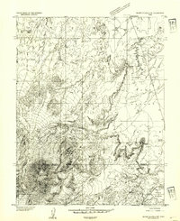
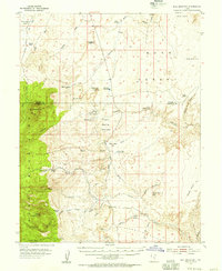 1952 Bull Mountain1956 Print · USGSGarfield County ranching and mining country are documented here in the early fifties, along the rugged border of the Burr Desert. Researchers can trace the layout of the Granite Ranch (Site), locate a high-elevation Mine, and follow the Granite Trail through the Henry Mountains.4 unique versions available
 - 1952 Map of Grover, 1957 Print
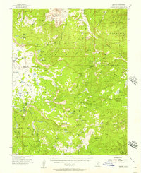 1952 Grover1957 Print · USGSSouthern Utah's high plateau country in the early fifties is captured here during a period of active timbering and grazing. Local history researchers can trace the roads to the Wildcat Ranger Sta, the old Sawmill, and numerous cattle ranges like Haws Pasture.3 unique versions available
 - 1952 Map of Torrey, 1958 Print
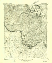
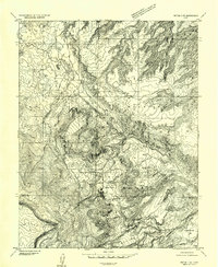
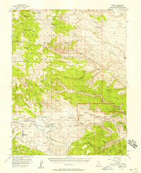 1952 Torrey1958 Print · USGSTorrey and Teasdale sit at the edge of the desert during the early 1950s, a time when the high plateaus and sandstone reefs were still navigated by jeep trails. Researchers can locate the local Cem, the Elkhorn Ranger Sta, and early infrastructure like the Power Plant along the Fremont River.3 unique versions available
 - 1952 Map of Notom, 1958 Print
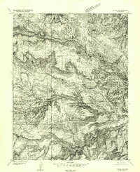
 1952 Notom1958 Print · USGSWayne and Garfield Counties were still a frontier of dirt tracks and remote cattle outposts in the early fifties. You can locate vanished ranching infrastructure and landmarks like Pleasant Creek Ranch, Notom, and the Pioneer Register along the massive Waterpocket Fold.3 unique versions available
 - 1952 Map of Loa 1 NE, 1973 Print
 1952 Loa 1 NE1973 Print · USGSWayne County ranching and remote mountain terrain define this mid-century survey of the Utah high plateaus. Genealogists and historians can trace irrigation networks like the High Line Ditch and find landmarks such as the Lyman Cemetery and Fremont village.
 - 1953 Map of Carlisle 3 NW, 1954 Print
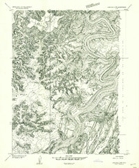 1953 Carlisle 3 NW1954 Print · USGSThe confluence of the Green and Colorado Rivers is captured here in the early fifties, showing the land before modern recreational mapping. Researchers can trace the sheer topography of Cataract Canyon, Spanish Bottom, and landmarks like Standing Rock.
 - 1953 Map of Orange Cliffs 1 SE, 1954 Print
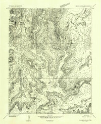 1953 Orange Cliffs 1 SE1954 Print · USGSThe Green River corridor and the canyons of Wayne County are shown in this mid-century survey as they were first being mapped by aerial photography. Researchers can trace the landforms of White Rim and find distinctive landmarks like Cleopatras Chair or Deadhorse Canyon.
 - 1953 Map of Orange Cliffs 4 NW, 1954 Print
 1953 Orange Cliffs 4 NW1954 Print · USGSWayne and Garfield counties are captured here in the early fifties during a period of intensive canyonland surveying. Researchers can trace the remote high-desert infrastructure of the era, from the Landing Strip on the flats to vital water sources like French Spring and Flint Spring.
 - 1953 Map of Orange Cliffs 4 NE, 1954 Print
 1953 Orange Cliffs 4 NE1954 Print · USGSRemote Wayne County terrain is captured in the early 1950s, showing a landscape defined by sharp elevation changes and deep drainages. Local history researchers can trace the natural landmarks of Big Water Canyon, The Edge, and the high reach of North Point.
 - 1953 Map of Orange Cliffs 3 NE, 1954 Print
 1953 Orange Cliffs 3 NE1954 Print · USGSWayne and Garfield Counties were marked by extreme isolation in the early fifties, accessible primarily by air or rugged trail. Researchers can trace the layout of the old Landing Strip on the mesa and locate water sources like Two Pipe Spring.
 - 1953 Map of Orange Cliffs 1 NE, 1954 Print
 1953 Orange Cliffs 1 NE1954 Print · USGSThe Green River meanders through the high desert of southeastern Utah in the early fifties, defining the borders of four counties. Trace the river's dramatic course through Stillwater Canyon past landmarks like Fort Bottom and Horsethief Point.
Showing maps 1-25 of 45
Top cities of Wayne County
- Loa historical maps
- Bicknell historical maps
- Lyman historical maps
- Hanksville historical maps
- Torrey historical maps
Frequently asked questions
- What are the different types of historical maps available for Wayne County?
- What is the oldest map of Wayne County?
- Where can I purchase historical maps of Wayne County for my home or office?
- Where can I download high-res historical maps of Wayne County?
- Are there historical topographic maps available for Wayne County?
- Is there historical aerial imagery available for Wayne County?
- Where are historical maps of Wayne County sourced from?