1950s Maps of Ogden, Utah
Explore 8 historic maps of Ogden from the 1950s. These maps offer a rare glimpse into what life looked like during the 1950s — showing old roads, neighborhoods, homes, and landmarks that have changed or disappeared over time.
Whether you're researching your family's past, planning a metal detecting trip, or studying how Ogden's landscape evolved across the 1950s, these high-resolution maps are a powerful tool for exploring the history of this region.
- Focus on a specific era: All maps on this page are from the 1950s, giving you a focused view of this time period.
- See what’s changed: Compare century-old streets, trails, and buildings to today's modern landscape using overlays and satellite layers.
- Research with precision: Use these maps for genealogy, historical research, land use analysis, or educational projects.
- View, download, or print: Maps are fully viewable online in high resolution, and can be downloaded or printed for your own records.
Start exploring Ogden's history through authentic maps from the 1950s. This is your window into the past.
Ogden, UT maps
(8)- 1954 Map of Ogden, 1967 Print
 1954 Ogden1967 Print · USGSThe northern Utah corridor and Wyoming borderlands are captured here in the mid-1950s, showing the region's transition from mountain wilderness to settled valleys. Researchers can trace historic institutions like Utah State University or locate vanished points like Church Butte Station and the Trappist Monastery.3 unique versions available
 - 1954 Map of Brigham City, 1968 Print
 1954 Brigham City1968 Print · USGSNorthern Utah and the edges of the Great Salt Lake are captured here during the mid-fifties, showing the region's transition from pioneer rail hubs to modern military ranges. Researchers can find old sidings like Lemay Siding, the Golden Spike Monument, and settlements like Washakie.4 unique versions available
 - 1955 Map of Ogden, 1956 Print
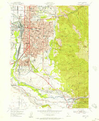 1955 Ogden1956 Print · USGSOgden thrived as a rail and military hub in the mid-fifties, squeezed between the river basins and the high peaks of the Wasatch Range. Genealogists and researchers can trace the urban development of South Ogden and Riverdale or locate family sites near the City Cemetery and Sacred Heart Academy.5 unique versions available
 - 1955 Map of Plain City, 1956 Print
 1955 Plain City1956 Print · USGSAgricultural life in mid-fifties Weber County is captured through its extensive irrigation systems and local hubs like Plain City and Farr West. Trace the path of the Ogden Railroad Grade or locate the West Weber Cem and Utah Hot Springs.2 unique versions available
 - 1955 Map of Roy, 1956 Print
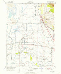
 1955 Roy1956 Print · USGSSettlements along the Weber River valley were rapidly evolving in the mid-fifties as military and rail hubs expanded. Genealogists and historians can trace the foundations of Roy and Clinton, locating family-named landmarks like the Clinton Cemetery and Lakeview School.4 unique versions available
 - 1955 Map of North Ogden, 1956 Print
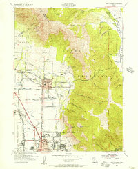 1955 North Ogden1956 Print · USGSThe Wasatch Front's transition from orchard lands to residential neighborhoods is captured here in the mid-fifties. Genealogists and researchers can trace family landmarks like the Ben Lomond Cemetery, the State Industrial School, and the Utah Idaho Central rail lines.5 unique versions available
 - 1958 Map of Ogden
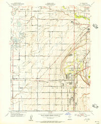
 1958 Ogden1958 Print · USGSNorthern Utah and southwestern Wyoming are captured here during a period of steady growth and military expansion. You can trace the Union Pacific rail lines and early road networks connecting Ogden and Logan to Bear Lake and Evanston.
 - 1958 Map of Brigham City
 1958 Brigham City1958 Print · USGSNorthern Utah in the late fifties shows a landscape of extremes, from the salt flats to the bustling Bear River Valley. Trace historical routes like the Old Immigrant Trail and locate local landmarks such as the Brigham Sugar Mill and Booth Valley School.
End of results
Showing maps 1-8 of 8
Top cities near Ogden
- Layton historical maps
- Roy historical maps
- Kaysville historical maps
- Syracuse historical maps
- Clearfield historical maps
- Farmington historical maps
See more
Top neighborhoods of Ogden
Frequently asked questions
- What are the different types of historical maps available for Ogden?
- What is the oldest map of Ogden?
- Where can I purchase historical maps of Ogden for my home or office?
- Where can I download high-res historical maps of Ogden?
- Are there historical topographic maps available for Ogden?
- Is there historical aerial imagery available for Ogden?
- Where are historical maps of Ogden sourced from?