1990s Maps of Ogden, Utah
Explore 8 historic maps of Ogden from the 1990s. These maps offer a rare glimpse into what life looked like during the 1990s — showing old roads, neighborhoods, homes, and landmarks that have changed or disappeared over time.
Whether you're researching your family's past, planning a metal detecting trip, or studying how Ogden's landscape evolved across the 1990s, these high-resolution maps are a powerful tool for exploring the history of this region.
- Focus on a specific era: All maps on this page are from the 1990s, giving you a focused view of this time period.
- See what’s changed: Compare century-old streets, trails, and buildings to today's modern landscape using overlays and satellite layers.
- Research with precision: Use these maps for genealogy, historical research, land use analysis, or educational projects.
- View, download, or print: Maps are fully viewable online in high resolution, and can be downloaded or printed for your own records.
Start exploring Ogden's history through authentic maps from the 1990s. This is your window into the past.
Ogden, UT maps
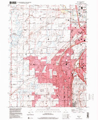
(8)- 1990 Map of Roy
 1990 Roy1990 Print · USGSThe corridor between Ogden and Clinton is shown here in the 1990s, defined by its massive military installations and expanding suburban grid. Researchers can trace local landmarks like Clinton Cem, the Ogden Municipal Airport, and the former Old Railroad Grade.2 unique versions available
 - 1992 Map of North Ogden
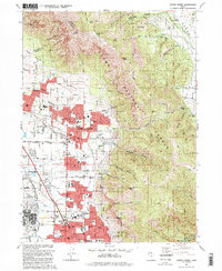 1992 North Ogden1992 Print · USGSNorth Ogden and the northern reaches of the Weber County valley are shown in the early 1990s as suburban expansion meets the Wasatch peaks. Researchers can trace local development through the Ben Lomond Cemetery, Lincoln Sch, and federal sites like the Defense Depot Ogden.2 unique versions available
 - 1992 Map of Ogden
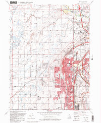
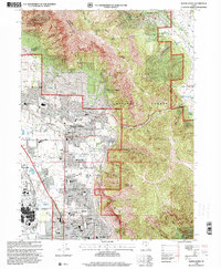
 1992 Ogden1992 Print · USGSThe Ogden area in the early nineties shows a thriving urban corridor bordered by the peaks of the Wasatch Range. Genealogists and historians can trace the development of Weber State University, the sprawling Defense Depot Ogden, and many local schools including St Josephs High Sch.2 unique versions available
 - 1992 Map of Plain City
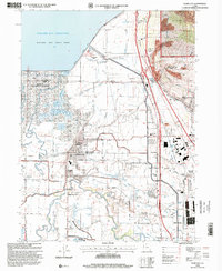
 1992 Plain City1992 Print · USGSWeber County at the start of the nineties shows a landscape of engineered waterways and growing communities between the Wasatch foothills and the Great Salt Lake. Researchers can locate family sites and local landmarks like Plain City, Wahlquist Jr High Sch, and the Defense Depot Ogden.
 - 1998 Map of North Ogden, 2001 Print
 1998 North Ogden2001 Print · USGSThe northern reaches of the Wasatch Front are captured here in the late nineties as residential growth meets the forest edge. Genealogists and local historians can locate Ben Lomond Cemetery, Harrisville, and the Golden Spike Arena.
 - 1998 Map of Plain City, 2001 Print
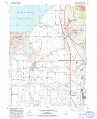
 1998 Plain City2001 Print · USGSThe Weber County lowlands come into focus in the late nineties as irrigation and recreation reshape the valley. Genealogists can trace family plots at Plain City Cem or follow the historic Ogden and Brigham City Electric RR through Farr West.
 - 1998 Map of Ogden, 2001 Print
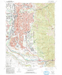
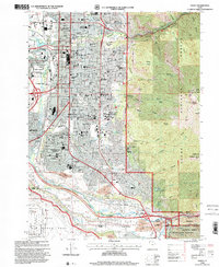 1998 Ogden2001 Print · USGSOgden at the end of the millennium shows a bustling urban center transitioning into the peaks of the Wasatch Range. Researchers can trace family sites at City Cemetery and Uintah Cemetery or locate historic schools like Ben Lomond High Sch.
 - 1999 Map of Roy, 2001 Print
 1999 Roy2001 Print · USGSWeber County's growing suburban and military landscape is captured here during the late 1990s as cities like Roy and Clinton expand. Researchers can trace family history at Stoker Memorial Cemetery or locate landmarks like Hill Air Force Base and the Aerospace Museum.
End of results
Showing maps 1-8 of 8
Top cities near Ogden
- Layton historical maps
- Roy historical maps
- Kaysville historical maps
- Syracuse historical maps
- Clearfield historical maps
- Farmington historical maps
See more
Top neighborhoods of Ogden
Frequently asked questions
- What are the different types of historical maps available for Ogden?
- What is the oldest map of Ogden?
- Where can I purchase historical maps of Ogden for my home or office?
- Where can I download high-res historical maps of Ogden?
- Are there historical topographic maps available for Ogden?
- Is there historical aerial imagery available for Ogden?
- Where are historical maps of Ogden sourced from?