1900s (20th Century) Maps of Marion, Virginia
Explore 11 historic maps of Marion from the 1900s (20th Century). These maps offer a rare glimpse into what life looked like during the 1900s — showing old roads, neighborhoods, homes, and landmarks that have changed or disappeared over time.
Whether you're researching your family's past, planning a metal detecting trip, or studying how Marion's landscape evolved across the 1900s, these high-resolution maps are a powerful tool for exploring the history of this region.
- Focus on a specific era: All maps on this page are from the 1900s, giving you a focused view of this time period.
- See what’s changed: Compare century-old streets, trails, and buildings to today's modern landscape using overlays and satellite layers.
- Research with precision: Use these maps for genealogy, historical research, land use analysis, or educational projects.
- View, download, or print: Maps are fully viewable online in high resolution, and can be downloaded or printed for your own records.
Start exploring Marion's history through authentic maps from the 1900s. This is your window into the past.
Marion, VA maps
(11)- 1909 Map of Abingdon
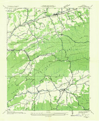
 1909 Abingdon1909 Print · USGSSouthwest Virginia at the first decade's end shows a valley landscape defined by the iron rail and steep ridges. Genealogists and historians can trace the early layouts of Abingdon and Glade Spring, or locate landmarks like Dove Mills and the County Farm.2 unique versions available
 - 1911 Map of Abingdon
 1911 Abingdon1911 Print · USGSSouthwest Virginia's rugged corridors are captured here during the height of the mountain rail era. Genealogists and historians can trace old homesteads and local landmarks such as Whites Mill, Valley Church, and the County Farm near Abingdon.5 unique versions available
 - 1931 Map of Rural Retreat
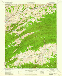
 1931 Rural Retreat1931 Print · USGSSouthwestern Virginia in the early 1930s is defined by its ridge-and-valley terrain and the rail-and-road corridor of the Norfolk and Western. Genealogists can trace local landmarks like Wasson Cem, Roberts Mill, and the Old Iron Mine near Sugar Grove.
 - 1935 Map of Atkins
 1935 Atkins1935 Print · USGSSmyth County was a landscape of mountain ridges and river valleys in the mid-1930s, caught between rail-line growth and deep wilderness. Trace family history at Wassum Cem, locate the Camp Jaccard CCC No 3581, or find the old Roberts Mill.
 - 1935 Map of Marion
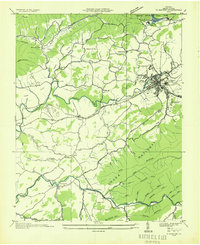 1935 Marion1935 Print · USGSMarion and its surrounding Smyth County valleys are captured during the mid-1930s, just as new conservation projects were shaping the landscape. Genealogists can trace family roots through numerous local landmarks like Holston Mill, the C C C Camp, and rural centers such as Adwolf and McMullin.
 - 1953 Map of Winston-Salem, 1974 Print
 1953 Winston-Salem1974 Print · USGSThe North Carolina Piedmont and Virginia highlands meet in the mid-1950s, a landscape defined by the tobacco and textile hubs of the Blue Ridge foothills. Researchers can trace the rail-and-river geography connecting Winston-Salem to mountain towns like Mount Airy and Galax.2 unique versions available
 - 1955 Map of Winston-Salem
 1955 Winston-Salem1955 Print · USGSThe Central Blue Ridge and Piedmont transition are captured here in the mid-fifties, from the industrial hub of Winston-Salem to the high peaks of Southwest Virginia. Genealogists can trace family landmarks like Richmond Hill Ch, Siloam Ch, and the old rail stops along the Southern Railway.
 - 1958 Map of Marion, 1960 Print
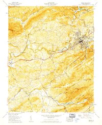 1958 Marion1960 Print · USGSSmyth County in the late fifties shows a landscape balanced between institutional growth in Marion and the high ridges of the Jefferson National Forest. Genealogists and historians can trace numerous rural landmarks like Wassum Valley Ch, the River Bend Cem, and the old Walker Creek School.6 unique versions available
 - 1958 Map of Atkins, 1960 Print
 1958 Atkins1960 Print · USGSSmyth County's mountain ridges and valley settlements are captured in the late fifties as rail and road travel transformed the region. Trace ancestral roots at Davis Memorial Ch or locate family sites like Roberts Mill and Attoway.6 unique versions available
 - 1962 Map of Winston-Salem
 1962 Winston-Salem1962 Print · USGSThe North Carolina Piedmont meets the Virginia highlands in the early sixties, showing the rail corridors and mountain gaps of the southern Appalachians. Researchers can trace the Blue Ridge Parkway or locate family sites near Winston-Salem, Mount Airy, and Hanging Rock Mountain.
 - 1982 Map of Wytheville, 1983 Print
 1982 Wytheville1983 Print · USGSSouthwest Virginia's ridge-and-valley landscape is shown here in the early 1980s as the Interstate era fully connected the region. Genealogists and historians can trace family locations near Emory and Henry College, the historic Austinville Mine, and settlements like Saltville or Lansing.3 unique versions available
End of results
Showing maps 1-11 of 11
Top cities near Marion
Frequently asked questions
- What are the different types of historical maps available for Marion?
- What is the oldest map of Marion?
- Where can I purchase historical maps of Marion for my home or office?
- Where can I download high-res historical maps of Marion?
- Are there historical topographic maps available for Marion?
- Is there historical aerial imagery available for Marion?
- Where are historical maps of Marion sourced from?