1970s Maps of Adams County, Washington
Explore 17 historic maps of Adams County from the 1970s. These maps offer a rare glimpse into what life looked like during the 1970s — showing old roads, neighborhoods, homes, and landmarks that have changed or disappeared over time.
Whether you're researching your family's past, planning a metal detecting trip, or studying how Adams County's landscape evolved across the 1970s, these high-resolution maps are a powerful tool for exploring the history of this region.
- Focus on a specific era: All maps on this page are from the 1970s, giving you a focused view of this time period.
- See what’s changed: Compare century-old streets, trails, and buildings to today's modern landscape using overlays and satellite layers.
- Research with precision: Use these maps for genealogy, historical research, land use analysis, or educational projects.
- View, download, or print: Maps are fully viewable online in high resolution, and can be downloaded or printed for your own records.
Start exploring Adams County's history through authentic maps from the 1970s. This is your window into the past.
Adams County, WA maps
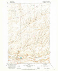
(17)- 1970 Map of Lind SE, 1973 Print
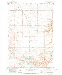
 1970 Lind SE1973 Print · USGSAdams County's agricultural heartland is captured here in the early seventies, showing a landscape defined by glacial coulees and family-named homestead roads. Researchers can locate the Delight Cem, the Sand Hills Grange Hall, and landmarks like McChesney Spring.
 - 1970 Map of Frischknecht, 1973 Print
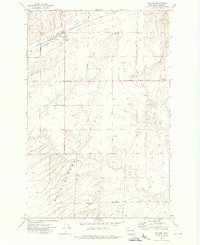
 1970 Frischknecht1973 Print · USGSFranklin County grain-growing country comes into focus in the early 1970s, as the rail and road network supported the region's agricultural harvest. Genealogists and historians can trace the Burlington Northern line to the Grain Elevators at Frischknecht and locate the Paradise Flats Cem.
 - 1970 Map of Lind SW, 1973 Print
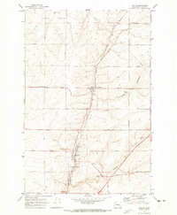
 1970 Lind SW1973 Print · USGSThe high plains of Adams County in the early 1970s are mapped here as a landscape of remote farmsteads and coulee systems. Researchers can trace early family connections through sites like Michigan Prairie Cem, the Woodward Elevator, and the settlement of Midway.
 - 1970 Map of Lind, 1973 Print
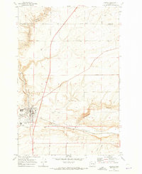
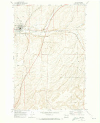 1970 Lind1973 Print · USGSLind flourished as a rail hub in the 1970s where two major lines intersected amidst the unique coulee geography of eastern Washington. Researchers can trace the town's layout including the High Sch and Lind Cem or follow rural routes like Wahl Road.
 - 1970 Map of Shano, 1973 Print
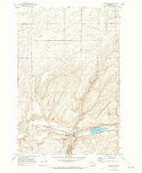
 1970 Shano1973 Print · USGSAdams County agriculture and water engineering are on full display in the early seventies as irrigation reshapes the landscape. Researchers can trace the path of the East Low Canal through the Shano Siphon to the Grain Elevators at Shano.2 unique versions available
 - 1970 Map of Roxboro, 1973 Print
 1970 Roxboro1973 Print · USGSAdams County’s agricultural heartland is captured here in the early seventies, centered on the high plateau and the rail lines through the coulees. Genealogists and local historians can trace family-named routes and remote landmarks like Kansas Prairie Cem, Woodruff Cem, and the siding at Servia.2 unique versions available
 - 1970 Map of Kahlotus, 1973 Print
 1970 Kahlotus1973 Print · USGSKahlotus and the surrounding coulee country are captured here in the early seventies, showing a landscape defined by rail and ranching. Genealogists and local historians can trace the Union Pacific corridor, locate Lakeview Cemetery, and explore the terrain of Michigan Prairie.
 - 1970 Map of Providence, 1973 Print
 1970 Providence1973 Print · USGSAdams County at the start of the 1970s shows a landscape shaped by rail and coulee drainage. Trace the crossing of the Burlington Northern and the Milwaukee Road near Providence and the Rodeo Grounds.
 - 1970 Map of Connell, 1973 Print
 1970 Connell1973 Print · USGSFranklin County's rail and agricultural heart is captured here during the early seventies as the region's transport network matured. Researchers can trace the path of the Northern Pacific railroad through Connell or locate family-named landmarks like Myers Road and Nordheim.
 - 1970 Map of Sulphur Lake, 1973 Print
 1970 Sulphur Lake1973 Print · USGSThe Franklin and Adams County line comes alive in the early seventies, showing a landscape defined by the deep Washtucna (Depression) Coulee. Trace the Union Pacific rail corridor to find local landmarks like Sulphur Lake, Estes, and numerous grain elevators.
 - 1970 Map of Hatton, 1973 Print
 1970 Hatton1973 Print · USGSAgricultural life in Adams County centers on Hatton during the early seventies, where rail lines meet the dry coulee country. Researchers can trace rural family-named routes like Kulm Road and locate key infrastructure including Grain Elevators and Storage Bins.
 - 1970 Map of Hatton NW, 1973 Print
 1970 Hatton NW1973 Print · USGSThe high desert of the Adams and Grant county line is captured here in the early 1970s, during the era of major irrigation development. You can trace the path of the Chicago Milwaukee St Paul and Pacific railroad and the massive Lind Coulee Siphon No 1 as they cross Lind Coulee.
 - 1972 Map of Washtucna North, 1974 Print
 1972 Washtucna North1974 Print · USGSThe rail and farming town of Washtucna is captured here in the early 1970s at a major inland grain junction. Genealogists and historians can trace the rail lines of the Burlington Northern and Union Pacific or locate local landmarks like the town Cem and Bassett Spring.
 - 1972 Map of Washtucna SW, 1974 Print
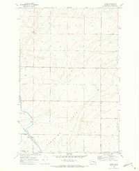
 1972 Washtucna SW1974 Print · USGSAdams County land use comes into focus in the early seventies, showing a highly organized landscape of large-scale agriculture and section-line roads. Researchers can trace family-named landmarks like Dewald Road and Thiel Road or locate features such as Rattlesnake Flat and Collier Coulee.
 - 1972 Map of Ralston, 1974 Print
 1972 Ralston1974 Print · USGSAgricultural life in Adams County during the 1970s is defined by the rail lines and grain silos of the high plateau. Researchers can trace rural genealogy at Bemis Cemetery or explore the rail hub of Ralston with its Grain Elevators and Grange Hall.2 unique versions available
 - 1972 Map of Pizarro, 1974 Print
 1972 Pizarro1974 Print · USGSAdams County’s agricultural landscape is seen here in the early 1970s, where rail and road networks intersect. Genealogists and historians can trace family-named routes like Suko Road and Dewald Road near the elevators at Pizarro.
 - 1979 Map of Priest Rapids
 1979 Priest Rapids1979 Print · USGSThe Columbia River basin in the late seventies reveals a landscape shaped by massive federal projects and rail expansion. Trace the Hanford Works perimeter, the Priest Rapids Dam, and the early growth of Royal City and Othello.2 unique versions available
End of results
Showing maps 1-17 of 17
Top cities of Adams County
- Othello historical maps
- Ritzville historical maps
- Lind historical maps
- Washtucna historical maps
- Hatton historical maps
Frequently asked questions
- What are the different types of historical maps available for Adams County?
- What is the oldest map of Adams County?
- Where can I purchase historical maps of Adams County for my home or office?
- Where can I download high-res historical maps of Adams County?
- Are there historical topographic maps available for Adams County?
- Is there historical aerial imagery available for Adams County?
- Where are historical maps of Adams County sourced from?