1960s Maps of Asotin County, Washington
Explore 7 historic maps of Asotin County from the 1960s. These maps offer a rare glimpse into what life looked like during the 1960s — showing old roads, neighborhoods, homes, and landmarks that have changed or disappeared over time.
Whether you're researching your family's past, planning a metal detecting trip, or studying how Asotin County's landscape evolved across the 1960s, these high-resolution maps are a powerful tool for exploring the history of this region.
- Focus on a specific era: All maps on this page are from the 1960s, giving you a focused view of this time period.
- See what’s changed: Compare century-old streets, trails, and buildings to today's modern landscape using overlays and satellite layers.
- Research with precision: Use these maps for genealogy, historical research, land use analysis, or educational projects.
- View, download, or print: Maps are fully viewable online in high resolution, and can be downloaded or printed for your own records.
Start exploring Asotin County's history through authentic maps from the 1960s. This is your window into the past.
Asotin County, WA maps
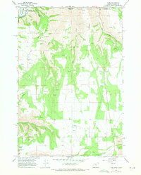
(7)- 1963 Map of Jim Creek Butte, 1965 Print
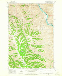 1963 Jim Creek Butte1965 Print · USGSThe Snake River canyon and the Wallowa high country meet in this mid-century survey of the Oregon-Idaho border. Researchers can trace the rugged network of trails and jeep tracks leading to remote landmarks like Jim Creek Butte, an isolated mine, and Cochran Islands.2 unique versions available
 - 1967 Map of Troy, 1971 Print
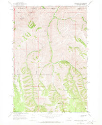
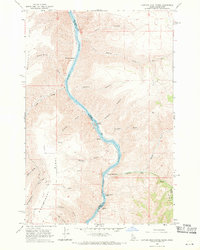
 1967 Troy1971 Print · USGSThe Oregon-Washington border region comes to life in the late sixties as the Grande Ronde River carves through the high plateaus. Genealogists and hikers can trace the remote settlement of Troy, the upland community of Bartlett, and the Bartlett Cem tucked away on the flat.2 unique versions available
 - 1967 Map of Paradise, 1971 Print
 1967 Paradise1971 Print · USGSThe Oregon and Washington borderlands in the late 1960s featured a high-country landscape of remote ridges and timbered canyons. Researchers can trace the layout of the Paradise settlement, locate the Paradise Cem, and follow a network of trails leading through Joseph Canyon to Tamarack Spring.2 unique versions available
 - 1967 Map of Teepee Butte, 1971 Print
 1967 Teepee Butte1971 Print · USGSThe high Wallowa backcountry at the turn of the 1970s is mapped here in detail. Researchers can trace seasonal movement through Hunting Camp Cow Camp, find Huffman Camp Spr, or follow the Pack Trail across Teepee Ridge.
 - 1967 Map of Flora, 1971 Print
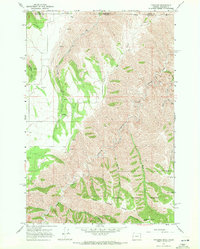
 1967 Flora1971 Print · USGSThe Oregon and Washington borderlands appear here in the late sixties, centered on the high-plateau settlement of Flora. Genealogists and historians can trace the early community via the Lost Prairie Cem, Nicoson Cem, and a Lookout Tower near the deep Grande Ronde River canyon.
 - 1968 Map of Captain John Rapids, 1971 Print
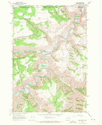
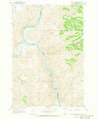
 1968 Captain John Rapids1971 Print · USGSThe Snake River canyonlands come alive in this late-sixties survey of the border between Idaho and Washington. Researchers can trace the river's navigational history through Captain John Rapids, Grahams Landing, and the Captain John Ferry.2 unique versions available
 - 1968 Map of Limekiln Rapids, 1971 Print
 1968 Limekiln Rapids1971 Print · USGSThe Snake River canyon at the Idaho-Washington border remains a wild waterway in the late sixties. Trace the river's hazardous path through Captain Lewis Rapids and Wild Goose Rapids past the riverside settlement of Rogersburg.3 unique versions available
End of results
Showing maps 1-7 of 7
Top cities of Asotin County
Frequently asked questions
- What are the different types of historical maps available for Asotin County?
- What is the oldest map of Asotin County?
- Where can I purchase historical maps of Asotin County for my home or office?
- Where can I download high-res historical maps of Asotin County?
- Are there historical topographic maps available for Asotin County?
- Is there historical aerial imagery available for Asotin County?
- Where are historical maps of Asotin County sourced from?