
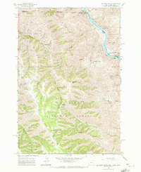
1963 Map of Jim Creek Butte
USGS Topo · Published 1965About this map
The Snake River carves a deep path through this borderland where Oregon, Idaho, and Washington meet, creating a landscape defined by dramatic elevation changes and treacherous water. Along the river’s edge, a unnamed mine and several navigation hazards like Lower Cache Creek Rapids and Upper Cache Creek Rapids reflect the difficult passage through the canyon. The interior is dominated by the Wallowa National Forest, where a network of trails and jeep tracks connects high-altitude landmarks like Jim Creek Butte and Lent Butte. Significant drainages such as Coon Creek and Cold Spring Creek feed the Snake, while the Baldwin Area suggests an era of high-country land use. This 1963 field-checked survey provides a meticulous record of the various gulches and ridges, including Dry Ridge and Smooth Gulch, that shaped the travel patterns of the region's early settlers and foresters.
Find a feature on this map
54 named features on this map. Tap any name to fly to it.
Don’t see what you’re looking for? This feature index may not catch every label — zoom into the map to look around manually.
Map Details
Editions of this 1963 Jim Creek Butte Map
2 editions found
Other maps of this area

1944 · Anatone
USGS Topo · 1:62,500

1946 · Limekiln Rapids
USGS Topo · 1:62,500

1946 · Anatone
USGS Topo · 1:62,500

1955 · Pullman
USGS Topo · 1:250,000

1955 · Grangeville
USGS Topo · 1:250,000

1958 · Pullman
USGS Topo · 1:250,000

1959 · Grangeville
USGS Topo · 1:250,000

1963 · Deadhorse Ridge
USGS Topo · 1:24,000

1963 · Wapshilla Creek
USGS Topo · 1:24,000

1963 · Poison Point
USGS Topo · 1:24,000