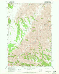
1967 Map of Paradise
USGS Topo · Published 1971About this map
Paradise and its surrounding high-country landscape are the focus of this 1967 field survey along the border of Asotin County, Washington, and Wallowa County, Oregon. The settlement is centered on a series of ridges and deep drainages, including the prominent Joseph Canyon and Applegate Can. This area is dominated by the Wallowa National Forest, where a network of trails and jeep tracks connects various springs and high points. Genealogy researchers may find interest in the Paradise Cem, which serves as a landmark for the small community. The mapping detail shows a rugged terrain defined by Rye Ridge and Horse Pasture Ridge, which slope down toward Joseph Creek. Numerous water sources, such as Tamarack Spring and Allen Spring, are scattered throughout the timbered canyons, indicating the area's importance for local livestock and forest management.
Find a feature on this map
25 named features on this map. Tap any name to fly to it.
Don’t see what you’re looking for? This feature index may not catch every label — zoom into the map to look around manually.
Map Details
Editions of this 1967 Paradise Map
2 editions found
Other maps of this area

1943 · Saddle Butte
USGS Topo · 1:62,500

1944 · Anatone
USGS Topo · 1:62,500

1946 · Saddle Butte
USGS Topo · 1:62,500

1946 · Anatone
USGS Topo · 1:62,500

1955 · Pullman
USGS Topo · 1:250,000

1955 · Grangeville
USGS Topo · 1:250,000

1958 · Pullman
USGS Topo · 1:250,000

1959 · Grangeville
USGS Topo · 1:250,000
1967 · Table Mountain
USGS Topo · 1:24,000
1967 · Billy Meadows
USGS Topo · 1:24,000