1940s Maps of Ferry County, Washington
Explore 12 historic maps of Ferry County from the 1940s. These maps offer a rare glimpse into what life looked like during the 1940s — showing old roads, neighborhoods, homes, and landmarks that have changed or disappeared over time.
Whether you're researching your family's past, planning a metal detecting trip, or studying how Ferry County's landscape evolved across the 1940s, these high-resolution maps are a powerful tool for exploring the history of this region.
- Focus on a specific era: All maps on this page are from the 1940s, giving you a focused view of this time period.
- See what’s changed: Compare century-old streets, trails, and buildings to today's modern landscape using overlays and satellite layers.
- Research with precision: Use these maps for genealogy, historical research, land use analysis, or educational projects.
- View, download, or print: Maps are fully viewable online in high resolution, and can be downloaded or printed for your own records.
Start exploring Ferry County's history through authentic maps from the 1940s. This is your window into the past.
Ferry County, WA maps
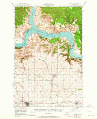
(12)- 1942 Map of Marcus
 1942 Marcus1942 Print · USGSUpper Stevens County in the late thirties shows a rugged landscape of rail-connected river towns and mountain mines. Trace family roots at the Old Catholic Mission or locate early industrial sites like the Kettle River Mine and Meyers Falls.3 unique versions available
 - 1948 Map of Curlew
 1948 Curlew1948 Print · USGSFerry County’s river-and-rail corridor is captured here in the late 1940s, showing the vital connection between the Canadian border and the interior. Researchers can trace the Great Northern line through Curlew and Danville, or locate family-named features like Lundimo Meadows and St Peter Cr.3 unique versions available
 - 1948 Map of Grand Coulee Dam, 1955 Print
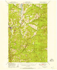
 1948 Grand Coulee Dam1955 Print · USGSThe Grand Coulee region underwent a massive transformation by the late 1940s as the dam transformed the river valley into a sprawling reservoir. Trace the growth of Coulee Dam and Grand Coulee, and locate rural landmarks like the Grand Coulee Grange and Bagdad Junction.6 unique versions available
 - 1948 Map of Republic, 1957 Print
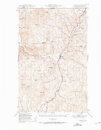
 1948 Republic1957 Print · USGSRepublic and the surrounding Ferry County high country are shown here in the late 1940s as a hub of mining and rail. You can trace the Great Northern tracks past Curlew Lake, locate the California Mine, and find the Fairweather Airport near town.2 unique versions available
 - 1948 Map of Sherman Peak, 1957 Print
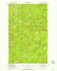 1948 Sherman Peak1957 Print · USGSThe high country of Ferry County is captured here in the late 1940s, showing a landscape of lookouts and forest outposts. You can trace early mountain routes through Sherman Creek Pass and locate isolated stations like Growden Guard Sta and Snowshoe Camp.2 unique versions available
 - 1948 Map of Kettle Falls, 1960 Print
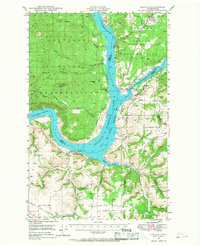
 1948 Kettle Falls1960 Print · USGSThe Kettle Falls region of Stevens County is captured here shortly after the creation of Lake Roosevelt. Genealogists and local historians can locate the community of Boyds, the Sherwood Sch (Aban'd), and family-named landmarks like Bisbee Mtn.
 - 1948 Map of Hunters, 1960 Print
 1948 Hunters1960 Print · USGSIn the late 1940s, this portion of Stevens County shows the impact of the newly created Lake Roosevelt on the Columbia River valley. Researchers can trace remote mining operations like the Cleveland Mine and Germania Mine or locate family roots near the Enterprise Cem and Cedonia Sch.2 unique versions available
 - 1948 Map of Orient, 1960 Print
 1948 Orient1960 Print · USGSIn the late 1940s, the remote valley of the Kettle River was a lifeline for border communities along the Great Northern rail line. Genealogists and historians can trace the foundations of local life through labels for the Barstow Sch, the Orient Ranger Station, and the Kettle River Mine.
 - 1948 Map of Togo Mountain, 1963 Print
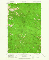 1948 Togo Mountain1963 Print · USGSFerry County’s high country is captured in the late 1940s, showing a landscape of rugged peaks and essential forest service outposts. Researchers can locate remote sites like the Summit Guard Sta or trace family history through landmarks like Ryan Cabin and Ryan Hill.2 unique versions available
 - 1948 Map of Wilbur, 1964 Print
 1948 Wilbur1964 Print · USGSLincoln County is captured here in the years following the creation of the Grand Coulee reservoir. Genealogists and historians can trace the rail-side growth of Wilbur and Creston or locate rural landmarks like the Potlatch Grange and Sherman.2 unique versions available
 - 1948 Map of Wilmont Creek, 1964 Print
 1948 Wilmont Creek1964 Print · USGSThe northern reaches of the Columbia River are captured here in the late 1940s, showing the early years of the massive reservoir. Genealogists and local historians can trace small communities like Kewa and Rogers Bar, noting the exact locations of the Kewa Cem and rural schools.
 - 1948 Map of Lincoln, 1968 Print
 1948 Lincoln1968 Print · USGSThe mid-century transformation of the upper Columbia River is captured here as the new reservoir rises. Researchers can trace the legacy of Fort Spokane, old schoolhouses like Enterprise Sch, and the layout of Bachelor Prairie.2 unique versions available
End of results
Showing maps 1-12 of 12
Top cities of Ferry County
Frequently asked questions
- What are the different types of historical maps available for Ferry County?
- What is the oldest map of Ferry County?
- Where can I purchase historical maps of Ferry County for my home or office?
- Where can I download high-res historical maps of Ferry County?
- Are there historical topographic maps available for Ferry County?
- Is there historical aerial imagery available for Ferry County?
- Where are historical maps of Ferry County sourced from?