1980s Maps of Franklin County, Washington
Explore 16 historic maps of Franklin County from the 1980s. These maps offer a rare glimpse into what life looked like during the 1980s — showing old roads, neighborhoods, homes, and landmarks that have changed or disappeared over time.
Whether you're researching your family's past, planning a metal detecting trip, or studying how Franklin County's landscape evolved across the 1980s, these high-resolution maps are a powerful tool for exploring the history of this region.
- Focus on a specific era: All maps on this page are from the 1980s, giving you a focused view of this time period.
- See what’s changed: Compare century-old streets, trails, and buildings to today's modern landscape using overlays and satellite layers.
- Research with precision: Use these maps for genealogy, historical research, land use analysis, or educational projects.
- View, download, or print: Maps are fully viewable online in high resolution, and can be downloaded or printed for your own records.
Start exploring Franklin County's history through authentic maps from the 1980s. This is your window into the past.
Franklin County, WA maps
(16)- 1980 Map of Walla Walla
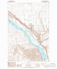
 1980 Walla Walla1980 Print · USGSThe Walla Walla Valley in the early eighties shows a landscape of deep-rooted agriculture and massive hydroelectric development. Researchers can trace the rail junctions at Wallula Junction, visit the historic Fort Walla Walla, or locate old landmarks like the Mountain View Cem.2 unique versions available
 - 1981 Map of Palouse Falls
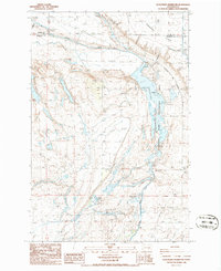
 1981 Palouse Falls1981 Print · USGSThe scablands of Eastern Washington are captured here in the early eighties, showcasing a landscape defined by the Palouse River and heavy rail. Researchers can trace the lines of the Union Pacific through Hooper Junction or locate remote landmarks like Gildersleeve Spring.
 - 1981 Map of Sperry
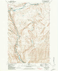
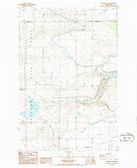
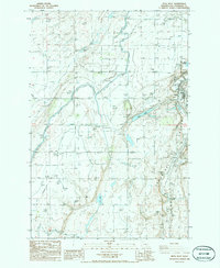
 1981 Sperry1981 Print · USGSFranklin County grain-farming and rail history are highlighted here in the early eighties as the industrial corridor follows the dramatic geology of the Washtucna Coulee. Researchers can find Sperry with its Grain Elevators, the settlement of Harder, and a local Cem near Lake Kahlotus.
 - 1981 Map of Ayer
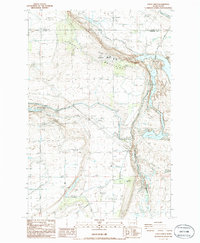
 1981 Ayer1981 Print · USGSThe Snake River corridor in the early eighties serves as a vital junction for rail and water transport along the Franklin and Walla Walla county line. Genealogists and researchers can trace the rail infrastructure at Ayer, locate the Ayer Boat Basin, or find the remote Landing Strip.
 - 1981 Map of Washtucna South
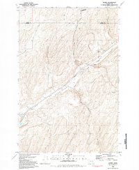
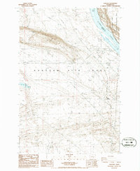
 1981 Washtucna South1981 Print · USGSFranklin and Adams County ranch lands are captured here in the early 1980s, centered on a critical rail corridor through the desert. Local researchers can trace family-named landmarks like H U Ranch and Davin Ranch alongside the busy Union Pacific rail lines.
 - 1981 Map of Starbuck West
 1981 Starbuck West1981 Print · USGSThe confluence of the Palouse and Snake Rivers is captured here in the early eighties, showcasing a landscape shaped by water and rail. Trace the Union Pacific line past Starbuck or locate the Marmes Rock Shelter and Old Bones Cem.
 - 1981 Map of Monumental Rock
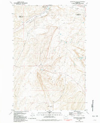
 1981 Monumental Rock1981 Print · USGSThe Snake River corridor in the early 1980s reveals a landscape of ranching and river-side industry. Genealogists and historians can trace family-named sites like Magallon Ranch and Tucker Farm or follow the Union Pacific line.
 - 1983 Map of Connell
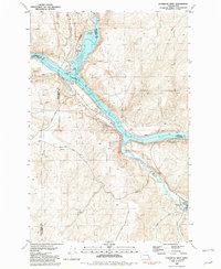
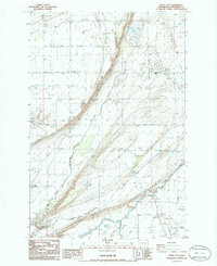
 1983 Connell1983 Print · USGSEastern Washington's coulee country is captured here in the early eighties as a landscape of remote rail junctions and massive river engineering. Trace family roots in Connell or Kahlotus, and follow old transport lines like the Old Lind Road Grade and Burlington Northern tracks.
 - 1986 Map of Scooteney Reservoir
 1986 Scooteney Reservoir1986 Print · USGSThe mid-1980s landscape of Franklin and Adams Counties is defined by the massive irrigation and energy works of the Columbia Basin Project. Researchers can trace the water and power network from the Potholes Canal to the Russell D Smith Powerplant.
 - 1986 Map of Hanford
 1986 Hanford1986 Print · USGSBenton and Franklin Counties were deeply transformed by federal utility during the 1980s. Local researchers can trace the restricted infrastructure of the Hanford Site (DOE), the townsite of Hanford, and the industrial grid around May Junction.
 - 1986 Map of Savage Island
 1986 Savage Island1986 Print · USGSThe Columbia River basin in the mid-1980s reveals a unique intersection of conservation and nuclear history. Researchers can trace the boundaries of the Hanford Site (DOE) and explore landmarks like Savage Island and Ringold Flat.
 - 1986 Map of Hanford NE
 1986 Hanford NE1986 Print · USGSFranklin County's landscape in the mid-1980s reveals the intersection of irrigation engineering and the secure perimeter of the Hanford Site Habitat Management Area. Researchers can trace the path of the Old RR Grade or locate infrastructure like the Wahluke Branch Canal and a local substation.
 - 1986 Map of Mesa West
 1986 Mesa West1986 Print · USGSFranklin County's agricultural heartland is captured in the mid-1980s, centered on the settlement of Mesa. Genealogists and historians can trace the paths of the Burlington Northern railroad, find the Old RR Grade, and locate landmarks like Old Maid Coulee and Worth Lake.
 - 1986 Map of Locke Island
 1986 Locke Island1986 Print · USGSThe mid-Columbia River region appears here in the mid-1980s, showcasing a landscape of significant habitat management and earlier industrial remains. Genealogists and historians can trace the Old RR Grade near Ruth or explore the geography of Locke Island and the White Bluffs.
 - 1986 Map of Eagle Lakes
 1986 Eagle Lakes1986 Print · USGSFranklin County and the high desert of the mid-eighties are captured here, showing the intersection of Cold War military sites and massive irrigation projects. Genealogists and historians can trace the Othello Air Force Sta, the Baillie Memorial Boys Ranch, and the complex network of the Wasteway.
 - 1986 Map of Basin City
 1986 Basin City1986 Print · USGSBasin City in the mid-eighties was a center for high-desert agriculture and irrigation engineering. Researchers can trace the water infrastructure of the Aqueduct and Siphon alongside local landmarks like the Rodeo Grounds and the Grain Elevator.
End of results
Showing maps 1-16 of 16
Top cities of Franklin County
- Pasco historical maps
- Connell historical maps
- Basin City historical maps
- Mesa historical maps
- Kahlotus historical maps
Frequently asked questions
- What are the different types of historical maps available for Franklin County?
- What is the oldest map of Franklin County?
- Where can I purchase historical maps of Franklin County for my home or office?
- Where can I download high-res historical maps of Franklin County?
- Are there historical topographic maps available for Franklin County?
- Is there historical aerial imagery available for Franklin County?
- Where are historical maps of Franklin County sourced from?