1960s Maps of Quincy, Washington
Explore 4 historic maps of Quincy from the 1960s. These maps offer a rare glimpse into what life looked like during the 1960s — showing old roads, neighborhoods, homes, and landmarks that have changed or disappeared over time.
Whether you're researching your family's past, planning a metal detecting trip, or studying how Quincy's landscape evolved across the 1960s, these high-resolution maps are a powerful tool for exploring the history of this region.
- Focus on a specific era: All maps on this page are from the 1960s, giving you a focused view of this time period.
- See what’s changed: Compare century-old streets, trails, and buildings to today's modern landscape using overlays and satellite layers.
- Research with precision: Use these maps for genealogy, historical research, land use analysis, or educational projects.
- View, download, or print: Maps are fully viewable online in high resolution, and can be downloaded or printed for your own records.
Start exploring Quincy's history through authentic maps from the 1960s. This is your window into the past.
Quincy, WA maps
(4)- 1965 Map of Ritzville
 1965 Ritzville1965 Print · USGSCentral Washington during the mid-sixties shows a landscape shaped by massive irrigation projects and the Cold War. Genealogists and historians can trace rail-town life and military presence through Ephrata Air Base, the Telford Station, and local schools.
 - 1966 Map of Monument Hill, 1967 Print
 1966 Monument Hill1967 Print · USGSGrant County is captured in the mid-1960s as a landscape of sharp ridges and developing infrastructure. Researchers can trace the agricultural footprint through labels like Storage Bin and Gravel Pit, or locate landmarks such as Baird Springs and the Radio Tower (KPOR).
 - 1966 Map of Quincy, 1968 Print
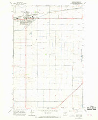 1966 Quincy1968 Print · USGSThe Columbia Basin's irrigation-driven growth is on full display in the 1960s as Quincy expands around the Great Northern rail line. Genealogists and local historians can map the town's social heart via the Grange Hall, Mountain View Sch, and the local Cem.
 - 1966 Map of Babcock Ridge, 1968 Print
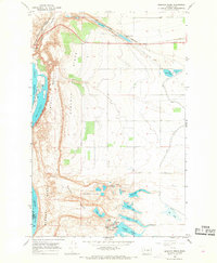 1966 Babcock Ridge1968 Print · USGSGrant County’s coulee landscape is captured here in the mid-sixties, showing the intersection of the Great Northern rail line and massive Columbia River water projects. Researchers can trace irrigation infrastructure like the Babcock Pumping Sta alongside local landmarks like Ancient Lake and Trinidad.2 unique versions available
End of results
Showing maps 1-4 of 4
Top cities near Quincy
Frequently asked questions
- What are the different types of historical maps available for Quincy?
- What is the oldest map of Quincy?
- Where can I purchase historical maps of Quincy for my home or office?
- Where can I download high-res historical maps of Quincy?
- Are there historical topographic maps available for Quincy?
- Is there historical aerial imagery available for Quincy?
- Where are historical maps of Quincy sourced from?