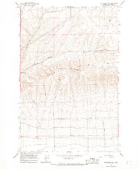
1966 Map of Monument Hill
USGS Topo · Published 1967About this map
Beezley Hills dominate the topography of this Grant County landscape, providing a dramatic vertical backdrop to the agricultural and infrastructure developments of the mid-1960s. The region is defined by deep incisions like Lynch Coulee, which shaped the placement of local transport routes including Baird Springs Road. The map reveals a working landscape where utility and communication take precedence, evidenced by the Radio Tower (KPOR) and a Landing Strip positioned on the flatter plains below the hills. Named settlements and landmarks like Baird Springs and Lynch provide specific points of interest for local historians, while scattered infrastructure such as a Storage Bin and various Gravel Pits illustrate the local economy. The network of unimproved roads like Overen Road and Monument Road trace the paths used by residents and workers during this era of Washington's development.
Find a feature on this map
18 named features on this map. Tap any name to fly to it.
Don’t see what you’re looking for? This feature index may not catch every label — zoom into the map to look around manually.
Map Details
Editions of this 1966 Monument Hill Map
This is the sole edition of this map. No revisions or reprints were ever made.
Other maps of this area

1909 · Quincy
USGS Topo · 1:62,500

1910 · Quincy
USGS Topo · 1:62,500

1910 · Winchester
USGS Topo · 1:62,500

1953 · Ritzville
USGS Topo · 1:250,000

1956 · Ephrata
USGS Topo · 1:62,500

1956 · Ephrata SW
USGS Topo · 1:24,000

1959 · Ritzville
USGS Topo · 1:250,000

1965 · Ritzville
USGS Topo · 1:250,000
1966 · Winchester
USGS Topo · 1:24,000
1966 · Palisades
USGS Topo · 1:24,000