Old Maps of Carnation, Washington for Academic Research
Study the evolution of Carnation with 12 high-resolution historic maps. Whether you're teaching, researching, or modeling changes in land use, these maps provide essential visual documentation of urban, environmental, and geographic change.
- Analyze long-term change: Track patterns in development, transportation, and natural features.
- Ideal for environmental or urban studies: Support academic projects with primary historical map data.
- Use in the classroom or lab: Educators and researchers rely on these maps to bring historical context to life.
These maps are a powerful tool for teaching, research, and visualizing how Carnation has changed over the decades.
Carnation, WA maps
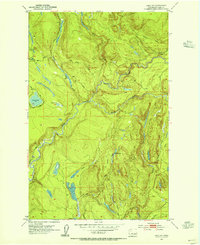
(12)- 1921 Map of Sultan
 1921 Sultan1921 Print · USGSThe Snoqualmie and Skykomish river valleys are defined by timber and rail in the 1920s. Researchers can trace early industry through the Apex Mines, Coke Ovens, and rural schools like Mountain View School.4 unique versions available
 - 1923 Map of Sultan
 1923 Sultan1923 Print · USGSThe Skykomish and Snoqualmie river valleys thrive in the early twenties as centers of timber and rail. Genealogists can trace family roots through rural sites like Forest Glade School or follow the Lumber RR lines to the Apex Mines.4 unique versions available
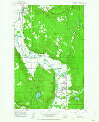
 - 1953 Map of Lake Joy, 1955 Print
 1953 Lake Joy1955 Print · USGSKing County timberlands and watersheds are captured here in the early fifties, showing the evolution of local logging infrastructure. Researchers can trace the Old Railroad Grade and Tolt Truck Trail past Lake Joy and the local Mill.4 unique versions available
 - 1953 Map of Carnation, 1963 Print
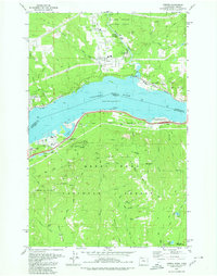
 1953 Carnation1963 Print · USGSThe Snoqualmie River valley in the early fifties shows a landscape of river-bottom farms and timbered hills. You can trace the rail lines of the Chicago Milwaukee St Paul and Pacific and locate sites like Carnation Farm and Stillwater.4 unique versions available
 - 1957 Map of Wenatchee, 1973 Print
 1957 Wenatchee1973 Print · USGSThe northern Cascades and Columbia River valley appear here in the mid-fifties, showing the region's critical rail and transit corridors. Researchers can trace the routes of the Great Northern RR and Milwaukee Road through settlements like Skykomish, Baring, and Dryden.2 unique versions available
 - 1975 Map of Skykomish River, 1977 Print
 1975 Skykomish River1977 Print · USGSThe Cascades meet the river valleys in the mid-seventies, showing the vital rail corridors and mountain towns along the Skykomish River. Researchers can trace the path of the Pacific Crest National Scenic Trail and locate historic sites like State Reformatory Farm No 2 and the Old Cascade Tunnel.2 unique versions available
 - 1979 Map of Carnation, 1980 Print
 1979 Carnation1980 Print · USGSThe Columbia River Gorge in the late seventies reveals a bustling corridor of timber, rail, and recreation. Researchers can trace the Burlington Northern tracks, locate the Oxbow Salmon Hatchery, or find the historic St Martins Hot Springs.
 - 1986 Map of Lake Joy, 2003 Print
 1986 Lake Joy2003 Print · USGSKing County's rugged eastern foothills are documented here in the mid-1980s, highlighting the critical water infrastructure of the Tolt River system. Researchers can trace rural settlements at Harris and Langlois or locate landmarks like Lake Joy and the Tolt Regulating Basin.
 - 1993 Map of Lake Joy
 1993 Lake Joy1993 Print · USGSKing County's water systems are meticulously charted here in the early nineties, showing a landscape defined by industrial forestry and utility. Trace the vital confluence of the North Fork Tolt River and the engineered Tolt Regulating Basin.
 - 1993 Map of Carnation
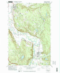 1993 Carnation1993 Print · USGSThe Snoqualmie River valley in the early 1990s showcases a landscape of riverside towns and agricultural heritage. Researchers can trace the Old Grade Railroad and find local landmarks such as Carnation Farm, Stillwater Sch, and the community at Lake Marcel.
 - 2023 Map of Carnation, 2023 Print
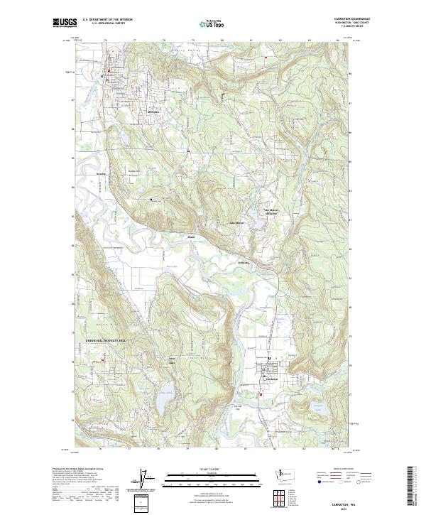 2023 Carnation2023 Print · USGSThe Snoqualmie River valley is captured here in the early 2020s, showing the settled landscape between Duvall and Carnation. Genealogists and local historians can trace family sites near Novelty Cem or locate landforms like Tolt Hill and Ames Lake.
 - 2023 Map of Lake Joy, 2023 Print
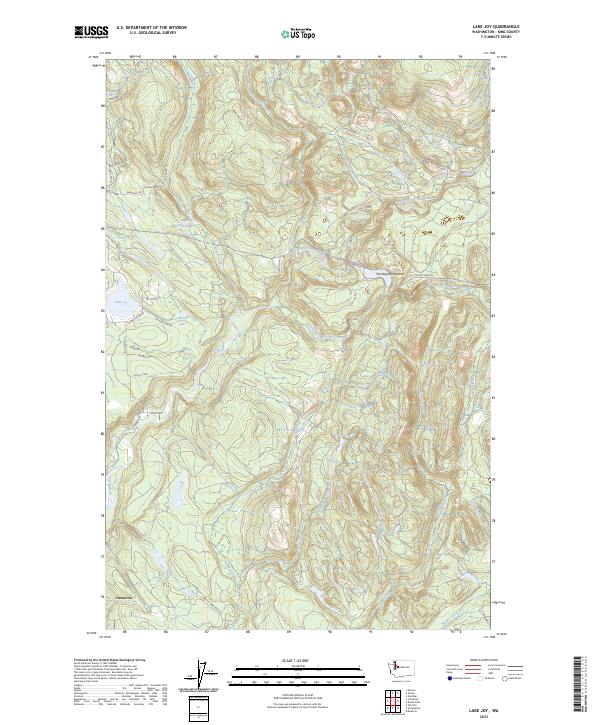 2023 Lake Joy2023 Print · USGSThe river valleys and timberlands of King County are shown here in the 2020s, centering on the growth around Carnation. Genealogists and locals can trace family-named routes and water features like Lake Joy, Moss Lake, and the Tolt Regulating Basin.
End of results
Showing maps 1-12 of 12
Top cities near Carnation
- Bellevue historical maps
- Kent historical maps
- Redmond historical maps
- Sammamish historical maps
- Issaquah historical maps
- Cottage Lake historical maps
See more
Frequently asked questions
- What are the different types of historical maps available for Carnation?
- What is the oldest map of Carnation?
- Where can I purchase historical maps of Carnation for my home or office?
- Where can I download high-res historical maps of Carnation?
- Are there historical topographic maps available for Carnation?
- Is there historical aerial imagery available for Carnation?
- Where are historical maps of Carnation sourced from?