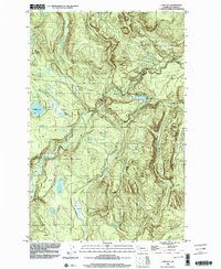
1986 Map of Lake Joy
USGS Topo · Published 2003About this map
Lake Joy and Moss Lake sit at the western edge of this terrain, where the foothills of the Cascades meet the developing suburban fringe of King County. The landscape is defined by the convergence of the North Fork Tolt River and South Fork Tolt River, featuring the Tolt Regulating Basin and several Gaging Stations that reflect the area's importance to regional water management. Small rural settlements like Harris and Langlois are noted, alongside numerous 4wd tracks and Borrow Pits that suggest a working landscape of timber and resource extraction. Significant watercourses including Griffin Creek, Stossel Creek, and Canyon Creek carve through the topography, which is bounded to the south by the Carnation Corp Bdy. The map provides a look at the intersection of natural watersheds and early infrastructure in the late 20th century.
Find a feature on this map
22 named features on this map. Tap any name to fly to it.
Don’t see what you’re looking for? This feature index may not catch every label — zoom into the map to look around manually.
Map Details
Editions of this 1986 Lake Joy Map
This is the sole edition of this map. No revisions or reprints were ever made.
Other maps of this area

1921 · Sultan
USGS Topo · 1:125,000

1923 · Sultan
USGS Topo · 1:125,000

1953 · Snoqualmie
USGS Topo · 1:24,000

1953 · Sultan
USGS Topo · 1:24,000

1953 · Lake Joy
USGS Topo · 1:24,000

1953 · Monroe
USGS Topo · 1:24,000

1953 · Fall City
USGS Topo · 1:24,000

1953 · Carnation
USGS Topo · 1:24,000

1956 · Monroe
USGS Topo · 1:62,500

1957 · Index
USGS Topo · 1:62,500