1970s Maps of Pierce County, Washington
Explore 11 historic maps of Pierce County from the 1970s. These maps offer a rare glimpse into what life looked like during the 1970s — showing old roads, neighborhoods, homes, and landmarks that have changed or disappeared over time.
Whether you're researching your family's past, planning a metal detecting trip, or studying how Pierce County's landscape evolved across the 1970s, these high-resolution maps are a powerful tool for exploring the history of this region.
- Focus on a specific era: All maps on this page are from the 1970s, giving you a focused view of this time period.
- See what’s changed: Compare century-old streets, trails, and buildings to today's modern landscape using overlays and satellite layers.
- Research with precision: Use these maps for genealogy, historical research, land use analysis, or educational projects.
- View, download, or print: Maps are fully viewable online in high resolution, and can be downloaded or printed for your own records.
Start exploring Pierce County's history through authentic maps from the 1970s. This is your window into the past.
Pierce County, WA maps
(11)- 1971 Map of Sunrise, 1974 Print
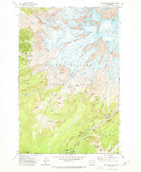
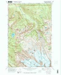
 1971 Sunrise1974 Print · USGSMount Rainier's northeast slopes in the early seventies show a landscape defined by retreating ice and rising alpine tourism. Traces of historical activity can be found at the Glacier Basin Mine, while hikers and historians can follow the Wonderland Trail past the Mt Fremont Lookout and the Sunrise Ranger Station.2 unique versions available
 - 1971 Map of White River Park, 1974 Print
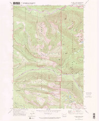
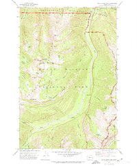 1971 White River Park1974 Print · USGSMount Rainier's northeast wilderness comes into focus in the 1970s, showing the high-elevation trails and ranger outposts of the Cascades. Researchers can trace the Pacific Crest National Scenic Trail past Sheep Lake or locate the Patrol Cabin and White River Ranger Station.3 unique versions available
 - 1971 Map of Mt Rainier West, 1974 Print
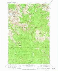
 1971 Mt Rainier West1974 Print · USGSMount Rainier's western glaciers and alpine meadows are captured in great detail during the early seventies. Hikers and historians can trace the Wonderland Trail past Mirror Lakes, the historic buildings at Longmire, and the Nisqually Mines.4 unique versions available
 - 1971 Map of Chinook Pass, 1974 Print
 1971 Chinook Pass1974 Print · USGSMount Rainier's eastern wilderness is documented here in the early seventies, capturing the intersection of high mountain passes and deep forest drainages. Hikers and historians can trace the Wonderland Trail, the Shriner Peak Lookout Tower, and the Grove of the Patriarchs.2 unique versions available
 - 1971 Map of Mount Wow, 1974 Print
 1971 Mount Wow1974 Print · USGSMount Rainier's western wilderness is captured here in the early seventies, detailing the transition from national forest to national park. Hikers and historians can trace the Wonderland Trail past the Marine Memorial Airplane Crash Monument and remote sites like Lake George.2 unique versions available
 - 1971 Map of Mt Rainier East, 1974 Print
 1971 Mt Rainier East1974 Print · USGSThe eastern slopes of the mountain in the early 1970s reveal a landscape of massive ice flows and established alpine trails. Trace the routes of climbers and hikers through Camp Muir, the Paradise Glacier Caves, and Reflection Lakes.2 unique versions available
 - 1971 Map of Mowich Lake, 1974 Print
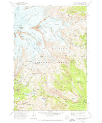
 1971 Mowich Lake1974 Print · USGSMount Rainier's northwest wilderness is charted in the early seventies, detailing the high glaciers and backcountry camps of the era. Hikers and researchers can trace the Wonderland Trail past Mowich Lake to remote landmarks like Mist Park and Spray Falls.2 unique versions available
 - 1971 Map of Golden Lakes, 1974 Print
 1971 Golden Lakes1974 Print · USGSMount Rainier's northern wilderness is captured here in the early 1970s, showcasing the high-country trails and ranger infrastructure of the day. Map collectors and hikers can trace the Wonderland Trail past the Tolmie Peak Lookout and the remote Golden Lakes.2 unique versions available
 - 1975 Map of Snoqualmie Pass, 1977 Print
 1975 Snoqualmie Pass1977 Print · USGSThe central Cascades are shown here in the mid-seventies, just as the regional balance between industrial timber, rail transport, and recreation was shifting. Genealogists and hikers can trace old rail stops like Lester and Nagrom, or follow the Pacific Crest National Scenic Trail past Keechelus Lake.
 - 1975 Map of Tacoma, 1977 Print
 1975 Tacoma1977 Print · USGSThe Puget Sound region in the mid-seventies reveals a landscape of growing urban centers and massive federal installations. Genealogists and historians can trace the development of Tacoma and Olympia, or locate landmarks like the McNeil Island Penitentiary and Fort Lewis Military Reservation.
 - 1978 Map of Mount Rainier
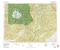 1978 Mount Rainier1978 Print · USGSThe high Cascades and the Yakima backcountry are shown in detail during the late seventies, centered on the glacial peaks and river valleys. Researchers can trace the development of Packwood and Goose Prairie or locate landmarks like the Packwood Landing Strip and Rimrock Lake.2 unique versions available
End of results
Showing maps 1-11 of 11
Top cities of Pierce County
- Tacoma historical maps
- South Hill historical maps
- Lakewood historical maps
- Puyallup historical maps
- Parkland historical maps
- Spanaway historical maps
See more
Frequently asked questions
- What are the different types of historical maps available for Pierce County?
- What is the oldest map of Pierce County?
- Where can I purchase historical maps of Pierce County for my home or office?
- Where can I download high-res historical maps of Pierce County?
- Are there historical topographic maps available for Pierce County?
- Is there historical aerial imagery available for Pierce County?
- Where are historical maps of Pierce County sourced from?