1980s Maps of Pierce County, Washington
Explore 20 historic maps of Pierce County from the 1980s. These maps offer a rare glimpse into what life looked like during the 1980s — showing old roads, neighborhoods, homes, and landmarks that have changed or disappeared over time.
Whether you're researching your family's past, planning a metal detecting trip, or studying how Pierce County's landscape evolved across the 1980s, these high-resolution maps are a powerful tool for exploring the history of this region.
- Focus on a specific era: All maps on this page are from the 1980s, giving you a focused view of this time period.
- See what’s changed: Compare century-old streets, trails, and buildings to today's modern landscape using overlays and satellite layers.
- Research with precision: Use these maps for genealogy, historical research, land use analysis, or educational projects.
- View, download, or print: Maps are fully viewable online in high resolution, and can be downloaded or printed for your own records.
Start exploring Pierce County's history through authentic maps from the 1980s. This is your window into the past.
Pierce County, WA maps
(20)- 1980 Map of Centralia
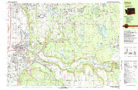
 1980 Centralia1980 Print · USGSThe rail and river corridors of southwestern Washington are captured here in the late twentieth century, showing the region's transition from resource extraction to managed forest land. Researchers can trace the industrial footprint of the Stoker Mine, the rails of the Union Pacific, and the early development of Centralia and Chehalis.
 - 1983 Map of Auburn
 1983 Auburn1983 Print · USGSThe Green River valley and its surrounding plateaus come into focus in the early eighties as residential growth meets deep-rooted industrial corridors. Genealogists and historians can locate family landmarks like the Muckleshoot Indian Reservation, Black Diamond, and Auburn Adventist Academy.
 - 1986 Map of Bearhead Mtn
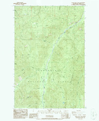
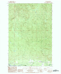
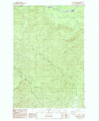
 1986 Bearhead Mtn1986 Print · USGSThe Cascades of Pierce County are captured here in the mid-1980s, detailing a landscape shaped by forest service management and mining history. Trace backcountry routes through Hurricane Gap or locate the site of the Clipper Mine Tunnel near Summit Lake.2 unique versions available
 - 1986 Map of Nagrom
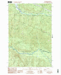
 1986 Nagrom1986 Print · USGSThe Central Cascades are captured in the mid-eighties just as modern conservation and infrastructure intersected with old mountain sites. Researchers can trace the Nagrom location, explore the Green River Watershed (City of Tacoma), and locate Bone Lake.
 - 1986 Map of Clear West Peak
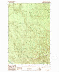
 1986 Clear West Peak1986 Print · USGSThe Snoqualmie National Forest in the 1980s reveals a landscape of high Cascade peaks and deep river valleys. Researchers can trace the network of 4WD tracks leading to remote sites like Mule Lake, The Palisades, and the summit of Clear West Peak.
 - 1986 Map of Sun Top
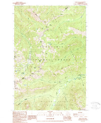
 1986 Sun Top1986 Print · USGSPierce County high country in the mid-1980s is defined by its dramatic ridges and national forest infrastructure. Researchers can locate the Sun Top LO lookout, the Ranger Creek Landing Strip, and old riverside sites like The Dalles Campground.
 - 1986 Map of Cyclone Creek
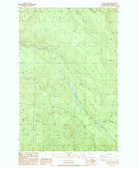
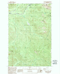
 1986 Cyclone Creek1986 Print · USGSThe King and Pierce county line follows the high Cascades in the mid-1980s, where the White River and Clearwater River meet. Researchers can trace the protected Green River Watershed and find remote landmarks like Beaverdam Lake and Grass Mountain.
 - 1986 Map of Greenwater
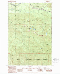
 1986 Greenwater1986 Print · USGSGreenwater and the high ridges of the Snoqualmie National Forest appear here in the mid-1980s, before modern development shifted the mountain landscape. Trace the former location of Humphrey (Site), explore Federation Forest State Park, and find the remote Mule Spring.2 unique versions available
 - 1986 Map of Old Baldy Mtn., 1987 Print
 1986 Old Baldy Mtn.1987 Print · USGSPierce County’s forested highlands are captured in the mid-1980s, showcasing a landscape of active resource extraction and conservation. Genealogists and historians can trace the area around Upper Fairfax or locate industrial markers like the Mine Tunnel and Quarry.
 - 1987 Map of Ashford
 1987 Ashford1987 Print · USGSThe community of Ashford is captured in the late eighties at the junction of Pierce and Lewis counties. Researchers can trace the Old Railroad Grade along the Nisqually River or locate local landmarks like the Landing Strip and Gaging Station.2 unique versions available
 - 1987 Map of Le Dout Creek
 1987 Le Dout Creek1987 Print · USGSPierce County’s river valleys and ridgelines are captured here in the late 1980s, documenting a landscape of steep timberlands and glacial drainages. Local historians and researchers can trace the course of the Puyallup River past the Dam and Gaging Station or explore the rugged network of 4WD trails crossing The Divide.2 unique versions available
 - 1987 Map of Elbe
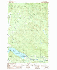 1987 Elbe1987 Print · USGSThe community of Elbe and the eastern end of Alder Lake are captured here during the late 1980s. Local researchers can trace the confluence of the Nisqually River and East Creek, or locate industrial sites like the many Borrow Pits and Park Junction.2 unique versions available
 - 1987 Map of Lake Kapowsin
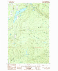 1987 Lake Kapowsin1987 Print · USGSPierce County’s timber and power landscape is captured here in the late eighties, centered on the waters of Lake Kapowsin. Researchers can trace industrial sites like the Powerhouse at Electron and identify geographic landmarks such as Wildcat Falls and Surprise Valley.2 unique versions available
 - 1987 Map of Anderson Lake
 1987 Anderson Lake1987 Print · USGSLewis County in the late 1980s is shown here as a landscape of deep timber and mountain drainages. Genealogists and outdoorsmen can trace old roads through Reese or locate remote water features like Anderson Lake and the Nisqually River.2 unique versions available
 - 1988 Map of Norse Peak
 1988 Norse Peak1988 Print · USGSThe central Washington Cascades are mapped here in the late eighties, documenting the high-altitude terrain along the Pierce and Yakima county line. Researchers can trace the path of the Pacific Crest National Scenic Trail through Bullion Basin and locate historical Mines along Morse Creek.2 unique versions available
 - 1988 Map of Cougar Lake, 1998 Print
 1988 Cougar Lake1998 Print · USGSThe high Cascades of Yakima County come into focus during the late eighties, where three national forests and a national park converge. Hikers and historians can trace the Pacific Crest National Scenic Trail past Cougar Lake and the Patrol Cabin.
 - 1989 Map of Raven Roost
 1989 Raven Roost1989 Print · USGSThe high ridges of the Cascades meet the Yakima valley headwaters in the late 1980s. Hikers and historians can trace the Pacific Crest Nat Scenic Trail past Raven Roost Radio Facility and the Huckleberry Forest Camp.
 - 1989 Map of Sawtooth Ridge
 1989 Sawtooth Ridge1989 Print · USGSMt Rainier National Park and the neighboring National Forests dominate this mountain landscape during the late eighties. Trace recreational and administrative sites like the Nisqually Entrance Ranger Station, the Lookout at High Rock, and the secluded Bertha May Lake.
 - 1989 Map of Noble Knob
 1989 Noble Knob1989 Print · USGSThe high Cascades of Washington's Pierce County are documented here in the late eighties, showing the path of the Pacific Crest National Scenic Trail through the timber. Trace the locations of Camp Urich, the high-altitude Corral Pass Campground, and remote landmarks like Noble Knob.2 unique versions available
 - 1989 Map of Wahpenayo Peak
 1989 Wahpenayo Peak1989 Print · USGSThe wilderness south of Mount Rainier comes into focus in the late eighties, documenting the intersection of national forest and park lands. Researchers can locate remote landmarks like Longmire, Bear Prairie, and the high ridges of the Tatoosh Range.
End of results
Showing maps 1-20 of 20
Top cities of Pierce County
- Tacoma historical maps
- South Hill historical maps
- Lakewood historical maps
- Puyallup historical maps
- Parkland historical maps
- Spanaway historical maps
See more
Frequently asked questions
- What are the different types of historical maps available for Pierce County?
- What is the oldest map of Pierce County?
- Where can I purchase historical maps of Pierce County for my home or office?
- Where can I download high-res historical maps of Pierce County?
- Are there historical topographic maps available for Pierce County?
- Is there historical aerial imagery available for Pierce County?
- Where are historical maps of Pierce County sourced from?