1910s Maps of Whatcom County, Washington
Explore 3 historic maps of Whatcom County from the 1910s. These maps offer a rare glimpse into what life looked like during the 1910s — showing old roads, neighborhoods, homes, and landmarks that have changed or disappeared over time.
Whether you're researching your family's past, planning a metal detecting trip, or studying how Whatcom County's landscape evolved across the 1910s, these high-resolution maps are a powerful tool for exploring the history of this region.
- Focus on a specific era: All maps on this page are from the 1910s, giving you a focused view of this time period.
- See what’s changed: Compare century-old streets, trails, and buildings to today's modern landscape using overlays and satellite layers.
- Research with precision: Use these maps for genealogy, historical research, land use analysis, or educational projects.
- View, download, or print: Maps are fully viewable online in high resolution, and can be downloaded or printed for your own records.
Start exploring Whatcom County's history through authentic maps from the 1910s. This is your window into the past.
Whatcom County, WA maps
(3)- 1915 Map of Mt. Baker, 1925 Print
 1915 Mt. Baker1925 Print · USGSUpper Whatcom and Skagit counties are seen here in the early twentieth century as railroads and mines began to pierce the wilderness. Genealogists and historians can locate early homesteads like Morovits Ranch, the Lone Jack Mine, and the route of the Great Northern railroad.3 unique versions available
 - 1918 Map of Samish Lake
 1918 Samish Lake1918 Print · USGSCoastal Skagit and Whatcom counties appear here during the height of the early twentieth-century timber and rail era. Researchers can pinpoint long-standing landmarks like the Alger Shingle Mill, Blue Canyon, and the State Fish Hatchery.3 unique versions available
 - 1919 Map of Van Zandt
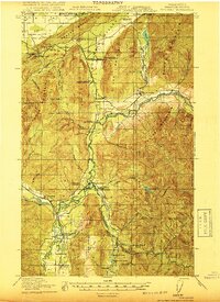 1919 Van Zandt1919 Print · USGSWhatcom County's timber and mining frontier is captured here at the end of the Great War, as railroads pushed deep into the river valleys. Genealogists can locate family landmarks like Heislers Ranch, the Peoples Store, and the Old Nooksack Mine along the Nooksack River.2 unique versions available
End of results
Showing maps 1-3 of 3
Top cities of Whatcom County
- Bellingham historical maps
- Lynden historical maps
- Ferndale historical maps
- Point Roberts historical maps
- Maple Falls historical maps
- Glacier historical maps
Frequently asked questions
- What are the different types of historical maps available for Whatcom County?
- What is the oldest map of Whatcom County?
- Where can I purchase historical maps of Whatcom County for my home or office?
- Where can I download high-res historical maps of Whatcom County?
- Are there historical topographic maps available for Whatcom County?
- Is there historical aerial imagery available for Whatcom County?
- Where are historical maps of Whatcom County sourced from?