2020s Maps of Whatcom County, Washington
Explore 71 historic maps of Whatcom County from the 2020s. These maps offer a rare glimpse into what life looked like during the 2020s — showing old roads, neighborhoods, homes, and landmarks that have changed or disappeared over time.
Whether you're researching your family's past, planning a metal detecting trip, or studying how Whatcom County's landscape evolved across the 2020s, these high-resolution maps are a powerful tool for exploring the history of this region.
- Focus on a specific era: All maps on this page are from the 2020s, giving you a focused view of this time period.
- See what’s changed: Compare century-old streets, trails, and buildings to today's modern landscape using overlays and satellite layers.
- Research with precision: Use these maps for genealogy, historical research, land use analysis, or educational projects.
- View, download, or print: Maps are fully viewable online in high resolution, and can be downloaded or printed for your own records.
Start exploring Whatcom County's history through authentic maps from the 2020s. This is your window into the past.
Whatcom County, WA maps
(71)- 2023 Map of Bertrand Creek, 2023 Print
 2023 Bertrand Creek2023 Print · USGSWhatcom County's rural landscape comes alive in this contemporary survey of the borderlands near the Canadian line. Genealogists and local historians can locate family plots at Enterprise Cem or trace property near Custer and the Nooksack River.
 - 2023 Map of Mount Sefrit, 2023 Print
 2023 Mount Sefrit2023 Print · USGSThe high peaks of the Skagit Range are captured here during the 2020s, showing the complex wilderness boundaries of Whatcom County. Hikers and researchers can trace vital backcountry routes through Hannegan Pass, Mamie Pass, and along the Silesia Creek Trail.
 - 2023 Map of Shull Mountain, 2023 Print
 2023 Shull Mountain2023 Print · USGSThe high North Cascades backcountry of Whatcom County is shown here in modern detail, dominated by the Pasayten Wilderness. Hikers and researchers can trace the Pacific Northwest National Scenic Trl across Devils Pass and locate the remote Shull Lake.
 - 2023 Map of Mount Triumph, 2023 Print
 2023 Mount Triumph2023 Print · USGSThe Skagit River valley and its high-altitude peaks are meticulously detailed in this recent survey of the North Cascades. Researchers can trace access routes like Thornton Lakes Road and locate landmarks such as Newhalem and Ladder Creek Falls.
 - 2023 Map of Twin Sisters Mountain, 2023 Print
 2023 Twin Sisters Mountain2023 Print · USGSThe peaks of Whatcom County are captured in this contemporary survey, documenting the alpine environment of the northern Cascades. Hikers and researchers can trace routes through Bell Pass and past secluded waters like Heart Lake and Bear Lake.
 - 2023 Map of Mount Larrabee, 2023 Print
 2023 Mount Larrabee2023 Print · USGSThe Cascades meet the international border in the early twenty-first century, revealing a high-altitude wilderness of summits and glacial lakes. Hikers and historians can trace the Pacific Northwest National Scenic Trail past landmarks like Mt Larrabee, Tomyhoi Lake, and American Border Peak.
 - 2023 Map of Mount Shuksan, 2023 Print
 2023 Mount Shuksan2023 Print · USGSThe high Cascades of Whatcom County appear in extensive detail through this recent topographical study. Mountaineers and researchers can trace the glaciated terrain of Mt Shuksan and locate remote routes like the Baker River Trl or the Shuksan Lake Trl.
 - 2023 Map of Mount Redoubt, 2023 Print
 2023 Mount Redoubt2023 Print · USGSThe North Cascades high country is captured here in the 2020s, showcasing a landscape of glaciers and alpine basins. Researchers can trace remote routes like the Little Beaver Trl or locate landmarks such as Mt Redoubt and Lake Reveille.
 - 2023 Map of Lummi Bay, 2023 Print
 2023 Lummi Bay2023 Print · USGSThe Whatcom County coastline meets the Salish Sea in this recent study of the Lummi Peninsula and its surrounding waters. Researchers can trace local landmarks like Mountain View Cem, the settlement at Cha-Choo-Sen, and the wetlands of the Lummi Flats.
 - 2023 Map of Pasayten Peak, 2023 Print
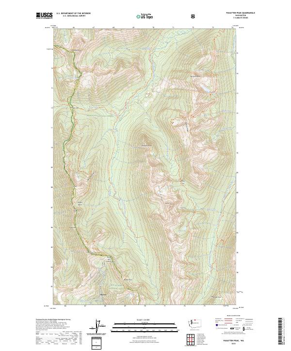 2023 Pasayten Peak2023 Print · USGSThe high Cascades of the Pasayten Wilderness are shown here in 2023, where remote trails and glacial peaks define the landscape. Hikers and historians can trace the Pacific Crest National Scenic Trl through Foggy Pass or locate the site of Barron.
 - 2023 Map of Blaine, 2023 Print
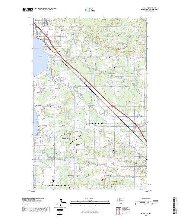 2023 Blaine2023 Print · USGSNear the Canadian border in the early 2020s, this area of Whatcom County shows a coastal landscape of harbors and rural hamlets. Genealogists can locate several local burial sites such as Zion Lutheran Cem and Enterprise Cem or trace the early paths of Portal Way.
 - 2023 Map of Canyon Lake, 2023 Print
 2023 Canyon Lake2023 Print · USGSWhatcom County's high timber country is captured here in the 2020s, showing the deep drainages between Slide Mtn and the Middle Fork Nooksack River. You can trace the legacy of local industry along the Anacortes Veneer Logging Rd and near Mosquito Lake.
 - 2023 Map of Sumas, 2023 Print
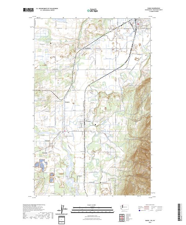 2023 Sumas2023 Print · USGSThe border country of Whatcom County comes into focus in this recent survey of the river valleys and mountain foothills. Researchers can trace family history through sites like Lake Side Cem and Nooksack Cem or locate old crossings at Clearbrook and Strandell.
 - 2023 Map of Strait of Georgia (All Water), 2023 Print
 2023 Strait of Georgia (All Water)2023 Print · USGSThe maritime crossroads of Whatcom County appear in this 2023 survey of the international waters near the Canadian border. Researchers can trace the modern boundaries of the Salish Sea and the significant expanses of Boundary Bay and Semiahmoo Bay.
 - 2023 Map of Mount Spickard, 2023 Print
 2023 Mount Spickard2023 Print · USGSThe high peaks of Whatcom County stand preserved in this recent survey of the North Cascades wilderness. Researchers can trace historic backcountry routes like the Little Beaver Trl as it winds past Mt Spickard and the remote waters of Silver Lake.
 - 2023 Map of Deming, 2023 Print
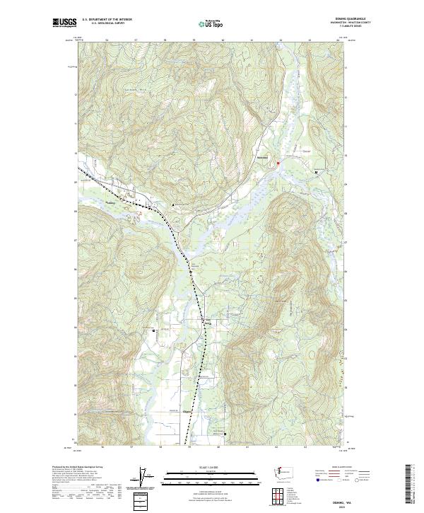 2023 Deming2023 Print · USGSSmall settlements and family burial grounds dot the Nooksack River valley in the early twenty-first century. Genealogists can trace roots at Saint Joseph Mission Cem or Mount Hope Cem, while exploring the river forks and landmarks like Van Zandt Dike.
 - 2023 Map of Mount Baker, 2023 Print
 2023 Mount Baker2023 Print · USGSThe glacial heights of the North Cascades are captured in this recent survey of the area around Mt Baker. Modern researchers can trace the movement of the Coleman Glacier and Easton Glacier or locate high-altitude landmarks like Sherman Crater and the Roman Wall.
 - 2023 Map of Mount Prophet, 2023 Print
 2023 Mount Prophet2023 Print · USGSThe Cascades of Whatcom County are shown here in the early twenty-first century as a strictly protected wilderness landscape. Trace the paths of the Pacific Northwest National Scenic Trl past Mt Prophet and the waters of Big Beaver Creek.
 - 2023 Map of Groat Mountain, 2023 Print
 2023 Groat Mountain2023 Print · USGSMount Baker National Forest and its high Cascades wilderness are documented in this contemporary survey of Whatcom County. Hikers and researchers can trace the extent of the Coleman Glacier and remote pathways like the Heliotrope Ridge Trl and Coal Pass.
 - 2023 Map of Ferndale, 2023 Print
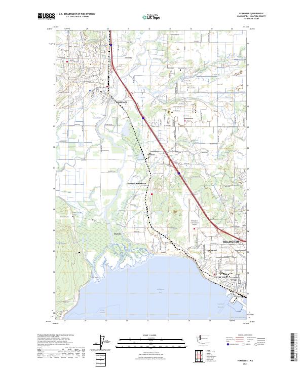 2023 Ferndale2023 Print · USGSCoastal Washington at the start of the 2020s shows a dynamic landscape where the Nooksack River meets the industrial and residential growth of Bellingham. Researchers can trace the modern development of Ferndale and locate significant local landmarks like Northwest Indian College and the BNSF Railway corridor.
 - 2023 Map of Bearpaw Mountain, 2023 Print
 2023 Bearpaw Mountain2023 Print · USGSThe high Cascades of Whatcom County appear in detail during the early 2020s, showing the borderlands where the national forest meets the Canadian frontier. Researchers can trace historic alpine routes like the High Divide Trl and locate remote water bodies including Whistler Lake and Nooksack Falls.
 - 2023 Map of Copper Mountain, 2023 Print
 2023 Copper Mountain2023 Print · USGSThe North Cascades backcountry is shown here in the contemporary era, illustrating the vital trail systems of the Stephen Mather Wilderness. Hikers and researchers can trace the Pacific Northwest National Scenic Trail past Egg Lake Camp and Copper Lake.
 - 2023 Map of Glacier, 2023 Print
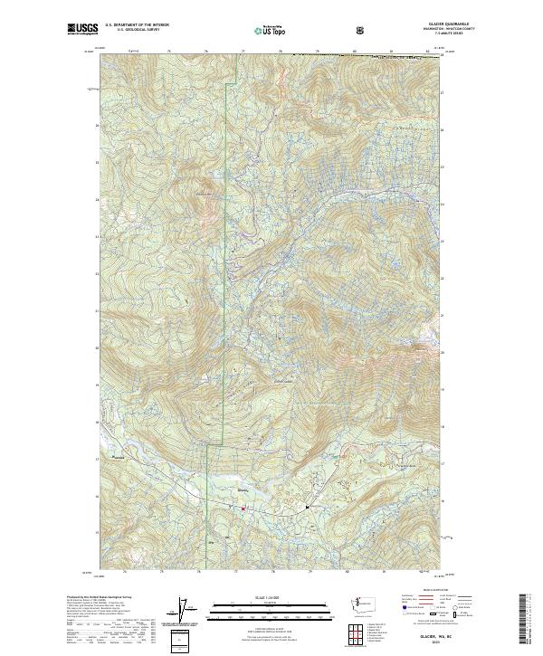 2023 Glacier2023 Print · USGSThe settlement of Glacier sits along the North Fork Nooksack River in the 2020s, a gateway to the high peaks of the North Cascades. Researchers can trace the town layout and local landmarks like Glacier Cem, Warnick, and the winding Canyon Ridge Trl.
 - 2023 Map of Kendall OE N, 2023 Print
 2023 Kendall OE N2023 Print · USGSThe international border and Pacific Northwest wilderness are documented here in the early 2020s. Researchers can trace the line between the Canada and the United States along with the survey boundaries of T41N R4E.
 - 2023 Map of Birch Point OE N, 2023 Print
 2023 Birch Point OE N2023 Print · USGSCoastal waters and the international boundary meet in this modern survey of the northern border. You can trace the shoreline of Semiahmoo Bay and see how the line for Canada United States of America divides the marine landscape.
Showing maps 1-25 of 71
Top cities of Whatcom County
- Bellingham historical maps
- Lynden historical maps
- Ferndale historical maps
- Point Roberts historical maps
- Maple Falls historical maps
- Glacier historical maps
Frequently asked questions
- What are the different types of historical maps available for Whatcom County?
- What is the oldest map of Whatcom County?
- Where can I purchase historical maps of Whatcom County for my home or office?
- Where can I download high-res historical maps of Whatcom County?
- Are there historical topographic maps available for Whatcom County?
- Is there historical aerial imagery available for Whatcom County?
- Where are historical maps of Whatcom County sourced from?