1990s Maps of Whatcom County, Washington
Explore 8 historic maps of Whatcom County from the 1990s. These maps offer a rare glimpse into what life looked like during the 1990s — showing old roads, neighborhoods, homes, and landmarks that have changed or disappeared over time.
Whether you're researching your family's past, planning a metal detecting trip, or studying how Whatcom County's landscape evolved across the 1990s, these high-resolution maps are a powerful tool for exploring the history of this region.
- Focus on a specific era: All maps on this page are from the 1990s, giving you a focused view of this time period.
- See what’s changed: Compare century-old streets, trails, and buildings to today's modern landscape using overlays and satellite layers.
- Research with precision: Use these maps for genealogy, historical research, land use analysis, or educational projects.
- View, download, or print: Maps are fully viewable online in high resolution, and can be downloaded or printed for your own records.
Start exploring Whatcom County's history through authentic maps from the 1990s. This is your window into the past.
Whatcom County, WA maps
(8)- 1997 Map of Lummi Bay, 2003 Print
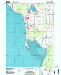 1997 Lummi Bay2003 Print · USGSCoastal Whatcom County shows a striking mix of heavy industry and reservation life during the late nineties. Researchers can trace the development of Sandy Point and the Refinery complex, or locate family sites near Mountain View Cem and the Lummi River.
 - 1997 Map of Point Roberts, 2003 Print
 1997 Point Roberts2003 Print · USGSPoint Roberts is shown here as a distinct American exclave in the late nineties, separated from the mainland by the international boundary. Researchers can trace the layout of Maple Beach, the U S Customs station, and waterfront landmarks like Lighthouse Park.
 - 1998 Map of Eliza Island, 2003 Print
 1998 Eliza Island2003 Print · USGSBellingham's southern waterfront and the surrounding San Juan islands are captured here in the late 1990s as coastal development met environmental conservation. Trace the streets of Fairhaven and Edgemoor or locate landmarks like Fairhaven Middle Sch and Eliza Island.
 - 1998 Map of Bellingham South, 2003 Print
 1998 Bellingham South2003 Print · USGSCoastal Bellingham and the high ridgelines of the Chuckanut Mountains meet here during the late nineties. Researchers can trace local development from the Larrabee School and Bayview Cemetery to the shores of Lake Samish and Chuckanut Village.
 - 1998 Map of Lummi Island, 2003 Print
 1998 Lummi Island2003 Print · USGSNorthern Puget Sound waters meet at Lummi Island in the late nineties, documenting a landscape of tribal lands and coastal retreats. Researchers can trace land use through the Lummi Indian Reservation, find Loganita Lodge, and locate the old Cem near Legoe Bay.
 - 1999 Map of Damnation Peak, 2002 Print
 1999 Damnation Peak2002 Print · USGSThe Skagit and Whatcom county highlands are shown at the close of the twentieth century, dominated by federally protected wilderness. Hikers and cartographic researchers can trace the high-elevation drainages of Bacon Creek and locate remote summits like Mount Despair and Damnation Peak.
 - 1999 Map of Bacon Peak, 2002 Print
 1999 Bacon Peak2002 Print · USGSThe high Cascades of Whatcom and Skagit counties are captured here at the close of the twentieth century. Researchers can trace the protected boundaries of the Noisy Diobsud Wilderness and locate remote features like Edgar Lake and Bacon Peak.
 - 1999 Map of Mount Triumph, 2002 Print
 1999 Mount Triumph2002 Print · USGSNewhalem and the Skagit River corridor are captured here just before the millennium, showcasing the intersection of three major federal land preserves. Researchers can trace the Thornton Lakes Trail up to Trappers Peak or locate riverside landmarks like the North Cascades Visitor Center.
End of results
Showing maps 1-8 of 8
Top cities of Whatcom County
- Bellingham historical maps
- Lynden historical maps
- Ferndale historical maps
- Point Roberts historical maps
- Maple Falls historical maps
- Glacier historical maps
Frequently asked questions
- What are the different types of historical maps available for Whatcom County?
- What is the oldest map of Whatcom County?
- Where can I purchase historical maps of Whatcom County for my home or office?
- Where can I download high-res historical maps of Whatcom County?
- Are there historical topographic maps available for Whatcom County?
- Is there historical aerial imagery available for Whatcom County?
- Where are historical maps of Whatcom County sourced from?