1980s Maps of Whatcom County, Washington
Explore 21 historic maps of Whatcom County from the 1980s. These maps offer a rare glimpse into what life looked like during the 1980s — showing old roads, neighborhoods, homes, and landmarks that have changed or disappeared over time.
Whether you're researching your family's past, planning a metal detecting trip, or studying how Whatcom County's landscape evolved across the 1980s, these high-resolution maps are a powerful tool for exploring the history of this region.
- Focus on a specific era: All maps on this page are from the 1980s, giving you a focused view of this time period.
- See what’s changed: Compare century-old streets, trails, and buildings to today's modern landscape using overlays and satellite layers.
- Research with precision: Use these maps for genealogy, historical research, land use analysis, or educational projects.
- View, download, or print: Maps are fully viewable online in high resolution, and can be downloaded or printed for your own records.
Start exploring Whatcom County's history through authentic maps from the 1980s. This is your window into the past.
Whatcom County, WA maps
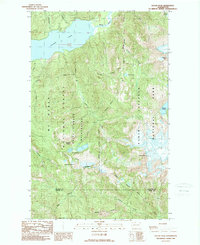
(21)- 1980 Map of Cavanaugh Creek
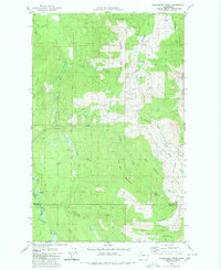 1980 Cavanaugh Creek1980 Print · USGSThe wilderness of the Whatcom and Skagit county line is captured in the late 1970s, showing a landscape defined by timber and forest service access. Trace the remote reaches of Skookum Creek, find high-country landmarks like Dailey Prairie, and follow old pack trails through the Mt Baker National Forest.2 unique versions available
 - 1980 Map of Acme, 1992 Print
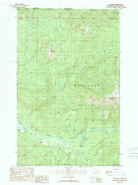
 1980 Acme1992 Print · USGSThe South Fork Nooksack River valley is shown during the early 1980s, documenting the corridor between Whatcom and Skagit counties. Researchers can trace the legacy of logging and rail at Wickersham, Mirror Lake Siding, and the Saxon Cem.2 unique versions available
 - 1981 Map of Roche Harbor
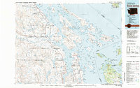 1981 Roche Harbor1981 Print · USGSThe maritime boundary between the Gulf Islands and San Juans was well-established by the early eighties. Researchers can trace transportation routes like the Canadian Pacific Railway and find coastal settlements from Sidney to Ganges.2 unique versions available
 - 1989 Map of Shuksan Arm
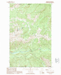
 1989 Shuksan Arm1989 Print · USGSThe high alpine country of the North Cascades is detailed here in the late twentieth century, showing a landscape defined by glaciers and remote mountain camps. Hikers and historians can trace routes to Baker Hot Spring, the Mount Baker Lodge, and the mineral Prospects near Austin Pass.2 unique versions available
 - 1989 Map of Groat Mountain
 1989 Groat Mountain1989 Print · USGSThe high peaks and forest lands of Whatcom County are documented here in the late 1980s, showcasing the transition from industrial utility to wilderness preservation. Researchers can trace the location of a historic Coal Mine near Coal Pass or explore the drainage of the Middle Fork Nooksack River.
 - 1989 Map of Copper Mountain
 1989 Copper Mountain1989 Print · USGSThe high wilderness of the North Cascades is documented here in the late eighties, just south of the Canadian border. Explorers and researchers can trace remote routes past a Cable Car Crossing and Foot Bridge along the Chilliwack River.
 - 1989 Map of Mount Blum
 1989 Mount Blum1989 Print · USGSIn the heart of the North Cascades during the late eighties, this wilderness remains an untouched alpine frontier. Hikers and historians can trace high-altitude routes through Chilliwack Pass, the waters of Blum Lakes, and the peaks of Mineral Mountain.
 - 1989 Map of Mt Challenger
 1989 Mt Challenger1989 Print · USGSThe North Cascades reached a point of high-detail documentation in the late eighties, focusing on the high-alpine interior of Whatcom County. Mountaineers and researchers can trace the extent of Challenger Glacier and locate remote landmarks like Perfect Pass and Mt Terror.2 unique versions available
 - 1989 Map of Mount Triumph
 1989 Mount Triumph1989 Print · USGSThe North Cascades in the late eighties show the intersection of industrial utility and wilderness preservation. You can trace the Skagit River through Newhalem and find high-country landmarks like Thornton Lakes and Mount Triumph.
 - 1989 Map of Mt Redoubt
 1989 Mt Redoubt1989 Print · USGSThe high peaks of Whatcom County meet the Canadian border in the 1980s, revealing a landscape shaped by ice and elevation. Hikers and researchers can trace the Pass Creek Trail between Whatcom Pass and the massive Redoubt Glacier.
 - 1989 Map of Damnation Peak
 1989 Damnation Peak1989 Print · USGSHigh in the North Cascades during the late eighties, this provisional survey captures a remote wilderness at the boundary of Whatcom and Skagit counties. Backcountry researchers can trace the alpine drainages of Blum Lakes and summits like Mt Despair or Oakes Peak.
 - 1989 Map of Bacon Peak
 1989 Bacon Peak1989 Print · USGSThe northern reaches of the Cascades are captured in the late 1980s, documenting the meeting of Whatcom and Skagit counties. Trace the remote drainages of Noisy Creek and Diobsud Creek or locate alpine landmarks like Watson Lakes and Bacon Peak.2 unique versions available
 - 1989 Map of Glacier
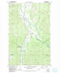
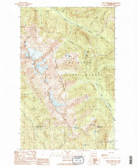
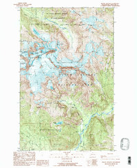
 1989 Glacier1989 Print · USGSThe mountain community of Glacier and the settlement of Warnick are shown at the end of the 1980s as they interface with the Mt Baker National Forest. Trace the winding North Fork Nooksack River or locate remote landmarks like Church Mountain and Bald Lake.2 unique versions available
 - 1989 Map of Mt Larrabee
 1989 Mt Larrabee1989 Print · USGSHigh in the Cascades during the late eighties, this survey captures the intersection of wilderness and industry along the international border. Researchers can trace the locations of high-altitude mining sites like Red Mountain Mine and Silvertip Mine or locate the CAMPGROUND near Twin Lakes.2 unique versions available
 - 1989 Map of Twin Sisters Mtn.
 1989 Twin Sisters Mtn.1989 Print · USGSThe high Cascades of Whatcom and Skagit counties are documented here during the late eighties, showing a landscape shaped by glacial water and alpine peaks. Researchers can trace the Bell Pass Trail and locate remote landmarks like George Peterson Butte or Lake Wiseman.2 unique versions available
 - 1989 Map of Mount Sefrit
 1989 Mount Sefrit1989 Print · USGSMount Sefrit and the surrounding Cascade high country are shown in the late 1980s, marking the remote intersection of British Columbia and Washington. Hikers and historians can trace the Hannegan Pass Trail or locate old mining Prospects and a Tunnel near Ruth Creek.
 - 1989 Map of Mount Baker
 1989 Mount Baker1989 Print · USGSMount Baker and its surrounding glaciers define the high-alpine landscape of Whatcom County in the late eighties. Researchers can trace the massive ice flows of Coleman Glacier and Mazama Glacier or locate landmarks like Grant Peak and Summit Crater.2 unique versions available
 - 1989 Map of Welker Peak
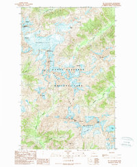
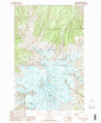
 1989 Welker Peak1989 Print · USGSThe North Cascades in the late 1980s are defined here by the waters of Baker Lake and the hydroelectric engineering of the Upper Baker Dam. Researchers can trace forest management sites like Koma Kulshan Guard Sta and several industrial Quarries.
 - 1989 Map of Baker Pass
 1989 Baker Pass1989 Print · USGSThe high alpine country of the North Cascades is documented here in the late eighties, just years after the wilderness area was formally established. Researchers can trace the path of the Railroad Grade, locate the Lookout Tower on Park Butte, and map the shifting margins of Squak Glacier.2 unique versions available
 - 1989 Map of Bearpaw Mountain
 1989 Bearpaw Mountain1989 Print · USGSThe high Cascades of Whatcom County appear in the late eighties as a landscape of wilderness management and early industry. Trace the mountain economy through the Excelsior Mine, the Nooksack Power Plant, and backcountry routes along Canyon Ridge.2 unique versions available
 - 1989 Map of Mount Shuksan
 1989 Mount Shuksan1989 Print · USGSThe high Cascades of Whatcom County appear in the late eighties as a preserved wilderness of ice and rock. Geologists and alpine historians can trace the extents of the Sulphide Glacier, Crystal Glacier, and the distinct Nooksack Cirque.2 unique versions available
End of results
Showing maps 1-21 of 21
Top cities of Whatcom County
- Bellingham historical maps
- Lynden historical maps
- Ferndale historical maps
- Point Roberts historical maps
- Maple Falls historical maps
- Glacier historical maps
Frequently asked questions
- What are the different types of historical maps available for Whatcom County?
- What is the oldest map of Whatcom County?
- Where can I purchase historical maps of Whatcom County for my home or office?
- Where can I download high-res historical maps of Whatcom County?
- Are there historical topographic maps available for Whatcom County?
- Is there historical aerial imagery available for Whatcom County?
- Where are historical maps of Whatcom County sourced from?